METAR & TAF KCON
Current METAR
Observed 16:51Z
KCON 271651Z AUTO VRB03KT 10SM CLR 28/14 A2982 RMK AO2 SLP096 T02830139
- Wind
- VAR @ 3 kt
- Visibility
- 10 SM
- Temp / Dew
- 28°C / 14°C
- Altimeter
- 29.82 inHg
- Clouds
- CLR
- Density alt
- 2,108 ft
- Ceiling
- Unlimited
- Rules
- VFR
Airport info & contacts
Manager on record, flight service, ARTCC, attendance schedule and pattern altitude — published by the FAA and refreshed every 28 days.
Location
- From city
- 2 NM E
- VFR sectional
- NEW YORK
- ARTCC
- ZBW · BOSTON
- NOTAM facility
- CON (NOTAM-D)
Airport manager
- Name
- DAVID ROLLA
- Phone
- 603-228-2267
- Address
- 71 AIRPORT RD, CONCORD NH 03301
Flight service · Hours
- FSS BGR
- BANGOR1-800-WX-BRIEF
- Attendance
- 0700-1700
Frequencies
Tap any row to copy the frequency to your clipboard.
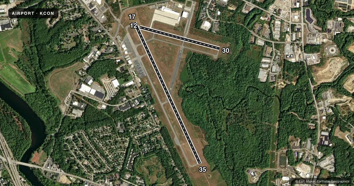
Runways & pattern
Full pagePattern entry · RWY 35
LEFT TRAFFIC| Runway | Heading (°M) | Length | Surface | Traffic |
|---|---|---|---|---|
| 17/35Favored | 139° / 319° | 6,005 ft | ASPH | Standard L |
| 12/30 | 89° / 269° | 3,200 ft | ASPH | Standard L |
Runway end performance
| End | TORA | TODA | ASDA | LDA | VGSI | Approach lights | Obstruction |
|---|---|---|---|---|---|---|---|
| 17 | — | — | — | — | PAPI 4-box left(3°) | — | 68', tree, 858' from thr, 105' R of cntrln, slope 9 |
| 35 | — | — | — | — | VASI 4-box left(3°) | MALSR | 64', trees, 662' from thr, 789' R of cntrln, slope 7 |
| 12 | — | — | — | — | — | — | 19', ant, 220' from thr, 133' R of cntrln, slope 1 |
| 30 | — | — | — | — | — | — | 13', gnd, 293' from thr, 143' R of cntrln, slope 7 |
Declared distances in feet. TORA = takeoff run available, TODA = takeoff distance, ASDA = accelerate-stop, LDA = landing distance.
Airport sketch
Runways drawn to scale from FAA survey coordinates, rendered over satellite imagery. Not for navigation.
Approaches & charts
ILS · 1
Services on the field
Fuel grades, oxygen, maintenance, ramp storage and lighting — as declared to the FAA by the airport operator.
Fuel & services
- Fuel
- 100LLA
- Oxygen (bottled)
- Not available
- Oxygen (bulk)
- Not available
- Airframe repair
- Major
- Power plant repair
- Major
- Other services
- AVNCS,INSTR,RNTL,SALES
Ramp & ground
- Transient storage
- Tie-down
- Hangar
- Landing fee
- No fee published
- Customs
- Not available
- Lighting schedule
- SEE RMK
- Beacon schedule
- SS-SR
- Beacon
- White / Green (civil land)(WG)
- Wind indicator
- Lighted
- Segmented circle
- No
Fuel & FBOs
Cheapest 100LL and Jet A on the field and nearby. Always confirm with the FBO before taxi.
Airport notes
Surface conditions, obstructions, local procedures, lighting outages and other notes published with each FAA cycle.
General notes
- WILDLIFE ON & INVOF ARPT.
- OPS ON NG TWY & RAMP PROHIBITED WO PRIOR CDN DUE TO SCTY.
- DAY & NGT VFR HEL OPS TO & FM NEW HAMPSHIRE STATE POLICE HNGR.
- OPS OFF PAVED SFCS PROHIBITED DUE TO CONSERVATION MGMT ACTS.
- RWY 35 DSGND CALM WIND RWY.
- MIL TWY & RAMP PCN R/A/W/T.
- HVY HEL ACT 1 NM ESE OF ARPT 800 FT & BLW.
- COMPASS ROSE CALIBRATED 2014.
- FOR CD CTC BOSTON APCH AT 603-594-5552.
Lighting notes
- ACTVT MALSR RWY 35; HIRL RWY 17/35; MIRL RWY 12/30 - CTAF.
Fuel notes
- 100LLSELF SVC 100LL AVBL 24 HRS WITH CREDIT CARD. FOR JET A AFT HRS CALL 603-228-2267 & FLW PROMPTS.
Approach & departure obstructions
- 3015 FT TREES 57 FT FM THR, 248 FT R.
- 17APCH SLP 26:1 TO DTHR.
Other notes
- THIS AIRPORT HAS BEEN SURVEYED BY THE NATIONAL GEODETIC SURVEY.
- EXISTED PRIOR TO 1959.
- 1EXC THANKSGIVING, CHRISTMAS, & NEW YEARS DAY.
- OWNERCITY MGR OFC.
VFR map & nearby airports
VFR sectional. Tap any ICAO chip to open that airport.
Key facts · KCON
Answer card- ICAO
- KCON
- Name
- CONCORD MUNI
- Location
- CONCORD, NEW HAMPSHIRE
- Elevation
- 341.7 ft MSL
- Traffic pattern altitude
- 1,341.7 ft MSL (1,000 AGL)
- Control tower
- Non-towered (use CTAF)
- Total runways
- 2
- Longest runway
- 17/35 · 6,005 ft
- Published ILS approaches
- 1
- Published frequencies
- 5
- Magnetic variation
- 16°
- Current flight rules
- VFR
- Current wind
- 000° at 3 kt
- Favored runway now
- RWY 35
Concord Muni sits in Concord, New Hampshire. Field elevation is 341.7 ft MSL. The airport has two asphalt runways. The longest is runway 17/35 at 6,005 ft. Runway 12/30 is 3,200 ft. There is no control tower. Expect non-towered operations on CTAF 122.7. The published pattern altitude is not listed. Use the standard 1,000 ft AGL for light piston traffic unless the current Chart Supplement says otherwise.
Runway 35 has the published ILS. The field is set up for both day and night VFR use. You should pay attention to the lighting setup before arrival. Runway 35 uses medium intensity approach lights with runway alignment indicator lights. Runways 17 and 35 have high intensity runway lights. Runways 12 and 30 have medium intensity runway lights. Runway 35 is also the calm wind runway.
Concord Aviation Services is on the field. It carries 100LL, Jet A and Jet A Prist. Self-serve 100LL is available 24 hours with a credit card. Wildlife is present on and near the airport. The north general taxiway and ramp need prior coordination because of security. There is also a tree obstruction near runway 30. The airport sits in a metro area. Check the current Chart Supplement for any noise or curfew restrictions before flying in.