METAR & TAF KROC
Current METAR
Observed 09:54Z
KROC 280954Z 21007KT 5SM TSRA BR FEW035CB BKN080 OVC120 19/18 A2965 RMK AO2 SLP039 FRQ LTGCCICCG VC SE-SW TS VC SE-SW MOV E P0016 T01940178
- Wind
- 210° @ 7 kt
- Visibility
- 5 SM
- Temp / Dew
- 19°C / 18°C
- Altimeter
- 29.65 inHg
- Clouds
- OVC
- Density alt
- 1,508 ft
- Ceiling
- 8,000 ft AGL
- Rules
- MVFR
Airport info & contacts
Manager on record, flight service, ARTCC, attendance schedule and pattern altitude — published by the FAA and refreshed every 28 days.
Location
- From city
- 3 NM SW
- VFR sectional
- DETROIT
- Pattern altitude
- 841 ft AGL · 1,400 ft MSL
- ARTCC
- ZOB · CLEVELAND
- NOTAM facility
- ROC (NOTAM-D)
Airport manager
- Name
- ANDREW MOORE
- Phone
- 585-753-7056
- Address
- 1200 BROOKS AVE, ROCHESTER NY 14624
Flight service · Hours
- FSS BUF
- BUFFALO1-800-WX-BRIEF
- Attendance
- ALL
Frequencies
Tap any row to copy the frequency to your clipboard.
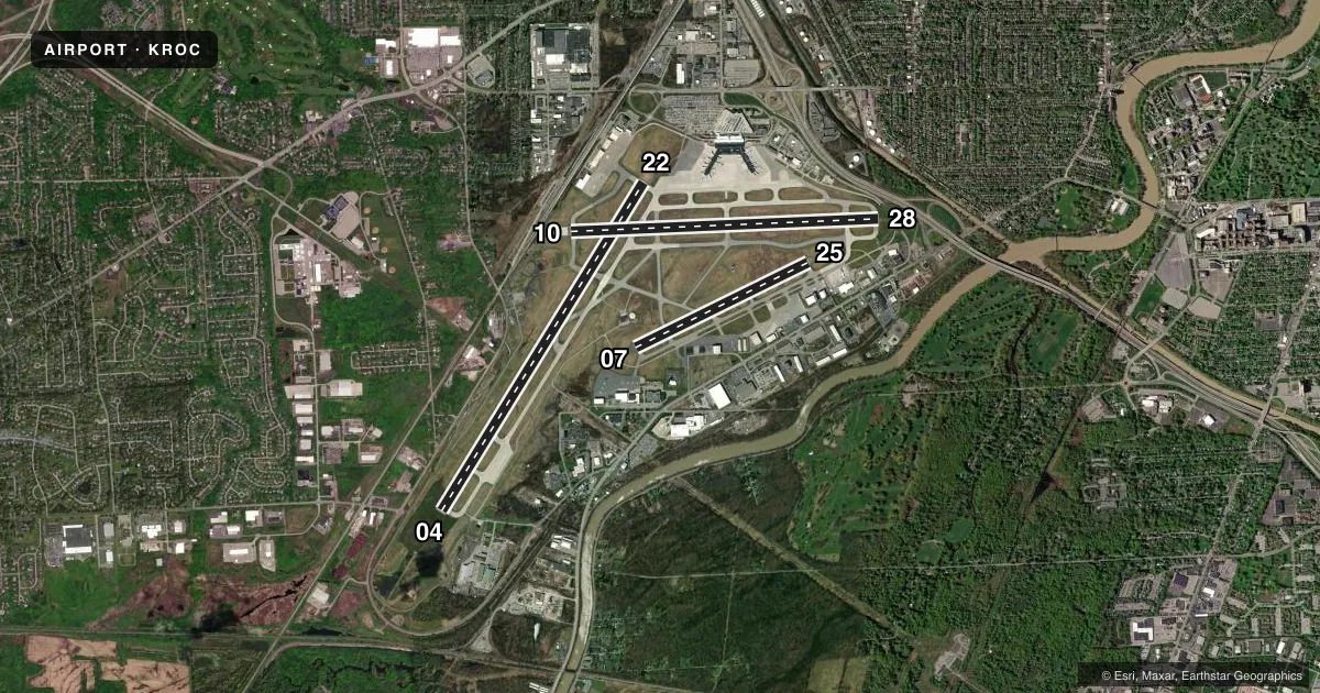
Runways & pattern
Full pagePattern entry · RWY 22
RIGHT TRAFFIC| Runway | Heading (°M) | Length | Surface | Traffic |
|---|---|---|---|---|
| 04/22Favored | 20° / 200° | 8,001 ft | ASPH | 22 R |
| 10/28 | 76° / 256° | 6,402 ft | ASPH | 10 R |
| 07/25 | 52° / 232° | 4,000 ft | ASPH | 07 R |
Runway end performance
| End | TORA | TODA | ASDA | LDA | VGSI | Approach lights | Obstruction |
|---|---|---|---|---|---|---|---|
| 04 | 8,001' | 8,001' | 8,001' | 8,001' | PAPI 4-box left(3°) | ALSF2 | 89', trees, 3080' from thr, 760' R of cntrln, slope 32 |
| 22 | 8,001' | 8,001' | 8,001' | 8,001' | PAPI 4-box left(3°) | MALSR | 54', tree, 2080' from thr, 520' R of cntrln, slope 34 |
| 10 | 6,402' | 6,402' | 5,802' | 5,502' | PAPI 4-box left(3°) | — | 62', trees, 1330' from thr, 460' R of cntrln, slope 18 |
| 28 | 6,402' | 6,402' | 6,402' | 5,802' | PAPI 4-box left(3°) | MALSR | 68', trees, 1213' from thr, 663' R of cntrln, slope 14 |
| 07 | 4,000' | 4,000' | 4,000' | 4,000' | — | — | 58', pole, 1740' from thr, 320' R of cntrln, slope 26 |
| 25 | 4,000' | 4,000' | 4,000' | 4,000' | PAPI 4-box right(3°) | — | 82', tree, 2720' from thr, 430' R of cntrln, slope 30 |
Declared distances in feet. TORA = takeoff run available, TODA = takeoff distance, ASDA = accelerate-stop, LDA = landing distance.
Airport sketch
Runways drawn to scale from FAA survey coordinates, rendered over satellite imagery. Not for navigation.
Approaches & charts
ILS · 3
Services on the field
Fuel grades, oxygen, maintenance, ramp storage and lighting — as declared to the FAA by the airport operator.
Fuel & services
- Fuel
- 100LLAJ8
- Oxygen (bottled)
- HIGH/LOW
- Oxygen (bulk)
- HIGH/LOW
- Airframe repair
- Major
- Power plant repair
- Major
- Other services
- AVNCS,CARGO,CHTR,INSTR,RNTL,SALES,SURV
Ramp & ground
- Transient storage
- Tie-down
- Hangar
- Landing fee
- Yes
- Customs
- Available
- Beacon schedule
- SS-SR
- Beacon
- White / Green (civil land)(WG)
- Wind indicator
- Lighted
- Segmented circle
- No
Fuel & FBOs
Cheapest 100LL and Jet A on the field and nearby. Always confirm with the FBO before taxi.
Airport notes
Surface conditions, obstructions, local procedures, lighting outages and other notes published with each FAA cycle.
General notes
- NO PRACTICE APCHS OR MAINT ENG RUN-UPS BTN 2300-0600.
- BE ALERT DURG LNDG/TKOF RYS 25 & 28 - THLDS IN CLOSE PROXIMITY TO EACH OTHER.
- BIRDS; DEER & COYOTE ON & INVOF ARPT.
- 80 FT OBST LGTD TWR 1250 FT WEST OF RY 04/22 CNTRLN 1000 FT SOUTH OF EXTDD CNTRLN RY 10/28.
- MULTIPLE UNSHIELDED LGTS IN FINAL APCH AREA RY 28.
- TWY "A2" CLSD TO HEAVY ACFT.
- TWY "F" FROM TWY "F1" TO RY 07 CLSD TO ACFT W/WINGSPAN GREATER THAN 100 FT.
- PAPI RWY 22; PAPI RWY 10, RWY 25 AND RWY 28 OPERATE 24 HRS.
- TERMINAL RAMP IS UNCONTROLLED. DO NOT CALL FOR PUSH/POWER BACK. ADVISE GROUND CONTROL WHEN READY TO TAXI FOR DEPARTURE.
Fuel notes
- J8FOR DOD ACFT.
Runway surface & condition
- 04/22PCR VALUE: 740/R/B/W/T
- 10/28PCR VALUE: 1190/F/C/X/T
- 07/25RWY 07/25 NOT AVBL FOR PART 121/PART 380 OPS WITH SKED PAX CARRYING OPS MORE THAN 9 PAX SEATS AND NON-SKED PAX CARRYING OPS MORE THAN 30 PAX SEATS.
Approach & departure obstructions
- 07RY 07 REIL CONTROLLED BY ATCT BUT NOT MONITORED.
- 10RY 10 REIL CONTROLLED BY ATCT BUT NOT MONITORED.
- 25RY 25 REIL CONTROLLED BY ATCT BUT NOT MONITORED.
- 10RWY 10 APCH RATIO 26:1 TO DSPLCD THLD.
- 28RWY 28 APCH RATIO 26:1 TO DSPLCD THLD.
Arresting gear
- 28_EMASENGINEERED MATERIALS ARRESTING SYSTEM (EMAS) 368 FT IN LENGTH BY 160 FT IN WIDTH LCTD AT THE DER 28.
Other notes
- ARPT EXISTED PRIOR TO 1959
- FLIGHT NOTIFICATION SERVICE (ADCUS ) AVAILABLE.
- TPA: 841 FT AGL SINGL ENG, 1441 FT AGL MULT ENG/TURBOPROP/JET.
VFR map & nearby airports
VFR sectional. Tap any ICAO chip to open that airport.
Key facts · KROC
Answer card- ICAO
- KROC
- Name
- FREDERICK DOUGLASS/GREATER ROCHESTER INTL
- Location
- ROCHESTER, NEW YORK
- Elevation
- 558.9 ft MSL
- Traffic pattern altitude
- 1,399.9 ft MSL (841 AGL)
- Control tower
- Towered · 24
- Total runways
- 3
- Longest runway
- 04/22 · 8,001 ft
- Published ILS approaches
- 3
- Published frequencies
- 18
- Magnetic variation
- 12°
- Current flight rules
- MVFR
- Current wind
- 210° at 7 kt
- Favored runway now
- RWY 22
Frederick Douglass/Greater Rochester Intl is in Rochester, New York. Field elevation is 558.9 ft MSL. The airport has three asphalt runways. The longest is runway 04/22 at 8,001 ft. Tower service is available 24 hours. The field has 3 ILS approaches for runway ends 04, 22 and 28.
Pattern altitude is 841 ft AGL for single-engine aircraft. That is 1,399.9 ft MSL. Multi-engine, turboprop and jet traffic uses 1,441 ft AGL. The airport sits in Class C airspace. Expect busy radio work and normal Class C sequencing.
USAirports Flight Support is on the field. It carries 100LL, Jet A and Jet A Prist. Avflight Rochester is also on the field. It carries 100LL, Jet A and Jet A Prist. For a first arrival, pay attention to the published notes. Runway 28 has multiple unshielded lights in the final approach area. Runway 25 and 28 thresholds are close together. Runway 07 end identifier lights are tower-controlled but not monitored. Birds, deer and coyote have been reported on and near the airport. Check the current FAA Chart Supplement for any current noise or operational restrictions before flying in.