METAR & TAF KPWA
Current METAR
Observed 19:53Z
KPWA 271953Z 21012G21KT 10SM CLR 38/17 A2986 RMK AO2 SLP091 T03830167
- Wind
- 210° @ 12G21 kt
- Visibility
- 10 SM
- Temp / Dew
- 38°C / 17°C
- Altimeter
- 29.86 inHg
- Clouds
- CLR
- Density alt
- 4,446 ft
- Ceiling
- Unlimited
- Rules
- VFR
Airport info & contacts
Manager on record, flight service, ARTCC, attendance schedule and pattern altitude — published by the FAA and refreshed every 28 days.
Location
- From city
- 7 NM NW
- VFR sectional
- DALLAS-FT WORTH
- ARTCC
- ZFW · FORT WORTH
- NOTAM facility
- PWA (NOTAM-D)
Airport manager
- Name
- KRISTY SLATER
- Phone
- 405-316-4061
- Address
- 5915 PHILIP J RHOADS RM 104, BETHANY OK 73008
Flight service · Hours
- FSS MLC
- MC ALESTER1-800-WX-BRIEF
- Attendance
- ALL
Frequencies
Tap any row to copy the frequency to your clipboard.
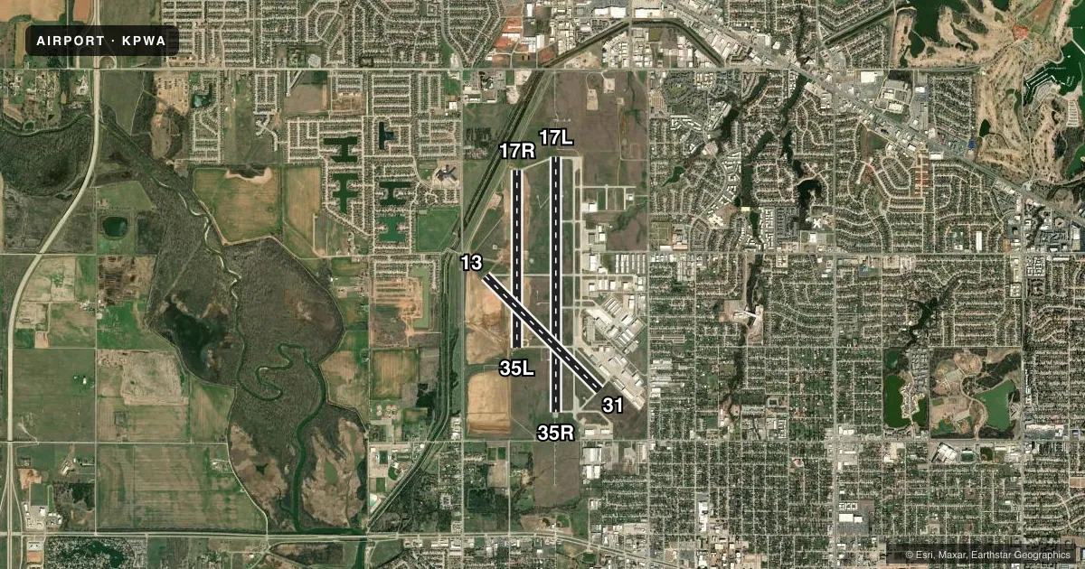
Runways & pattern
Full pagePattern entry · RWY 17L
RIGHT TRAFFIC| Runway | Heading (°M) | Length | Surface | Traffic |
|---|---|---|---|---|
| 17L/35RFavored | 175° / 355° | 7,199 ft | CONC | 17L R |
| 17R/35L | 175° / 355° | 5,002 ft | ASPH-CONC | 17R R |
| 13/31 | 130° / 310° | 4,562 ft | CONC | 13 R |
Runway end performance
| End | TORA | TODA | ASDA | LDA | VGSI | Approach lights | Obstruction |
|---|---|---|---|---|---|---|---|
| 17L | 7,199' | 7,199' | 6,844' | 6,844' | PAPI 4-box left(3°) | MALSR | — |
| 35R | 7,198' | 7,198' | 7,198' | 6,844' | PAPI 4-box left(3°) | MALSR | — |
| 17R | 5,002' | 5,002' | 5,002' | 5,002' | PAPI 4-box left(3°) | — | — |
| 35L | 5,001' | 5,001' | 5,001' | 5,001' | PAPI 4-box left(3°) | — | — |
| 13 | 4,562' | 4,562' | 4,562' | 4,562' | — | — | — |
| 31 | 4,562' | 4,562' | 4,562' | 4,562' | — | — | — |
Declared distances in feet. TORA = takeoff run available, TODA = takeoff distance, ASDA = accelerate-stop, LDA = landing distance.
Airport sketch
Runways drawn to scale from FAA survey coordinates, rendered over satellite imagery. Not for navigation.
Approaches & charts
ILS · 2
Services on the field
Fuel grades, oxygen, maintenance, ramp storage and lighting — as declared to the FAA by the airport operator.
Fuel & services
- Fuel
- 100LLA+
- Oxygen (bottled)
- HIGH/LOW
- Oxygen (bulk)
- HIGH/LOW
- Airframe repair
- Major
- Power plant repair
- Major
- Other services
- AMB,AVNCS,CHTR,INSTR,RNTL,SALES,SURV
Ramp & ground
- Transient storage
- Tie-down
- Hangar
- Landing fee
- No fee published
- Customs
- Not available
- Lighting schedule
- SEE RMK
- Beacon schedule
- SS-SR
- Beacon
- White / Green (civil land)(WG)
- Wind indicator
- Lighted
- Segmented circle
- Yes
Fuel & FBOs
Cheapest 100LL and Jet A on the field and nearby. Always confirm with the FBO before taxi.
Airport notes
Surface conditions, obstructions, local procedures, lighting outages and other notes published with each FAA cycle.
General notes
- BIRDS ON & INVOF ARPT.
- RWY 17L/35R NOISE ABATEMENT PROC IN EFCT; DEP ACFT 12500 LBS OR GTR CLIMB AT MAX RATE CONSISTENT WITH SAFETY TO 1500 FT AGL THEN REDUCE PWR & CLIMB RATE TO 3000 FT AGL OR 2 NM FM ARPT DEPENDING ON ATC & SAFETY CONDS.
- EXP PONDING DURG WET COND ON RWY 17L/35R AT INT OF RWY 13/31.
- SFC COND RPRTD MON-FRI 1300-0400Z.
- FOR CD IFUN TO CTC GND CON, CTC OKE CITY APCH AT 405-681-5683.
Lighting notes
- WHEN ATCT CLSD ACTVT MALSR RWY 17L & 35R; REIL RWY 17R & 35L; HIRL RWY 17L/35R; MIRL RWY 17R/35L, 13/31 - CTAF. PAPI RWY 17L & 35R, 17R & 35L ON CONSLY.
Fuel notes
- 100LL100LL AVBL H24 SELF SVC WITH CREDIT CARD.
Runway surface & condition
- 13/31CLSD 0400-1300Z; ACFT OVR 12500 LBS GWT NA.
- 17L/35RUNLGTD 0400-1300Z.
Other notes
- PRE DATES THE ACT.
- 0400-1300Z.
- TPA RWY 17R/35L 600 FT AGL, ALL OTHER RWYS 1000 FT AGL.
VFR map & nearby airports
VFR sectional. Tap any ICAO chip to open that airport.
Key facts · KPWA
Answer card- ICAO
- KPWA
- Name
- WILEY POST
- Location
- OKLAHOMA CITY, OKLAHOMA
- Elevation
- 1,299.6 ft MSL
- Traffic pattern altitude
- 2,299.6 ft MSL (1,000 AGL)
- Control tower
- Towered · 0700-2200
- Total runways
- 3
- Longest runway
- 17L/35R · 7,199 ft
- Published ILS approaches
- 2
- Published frequencies
- 15
- Magnetic variation
- 5°
- Current flight rules
- VFR
- Current wind
- 210° at 12 kt
- Favored runway now
- RWY 17L
Wiley Post Airport is in Oklahoma City, Oklahoma. The field elevation is 1,299.6 ft MSL. It has three runways. The longest is 7,199 ft on 17L/35R. The tower is open daily from 0700 to 2200. Two ILS approaches are published. They serve runway ends 17L and 35R.
For pattern work, the published traffic pattern altitude is 600 ft AGL for runway 17R/35L. All other runways use 1,000 ft AGL. That matters here because the field sits high enough that density altitude can be a factor in warm weather. Runway 17L/35R also has published noise abatement procedures for heavier departures. Check the current Chart Supplement before you go if you need the exact wording for your aircraft.
On the field, Atlantic Aviation carries 100LL and Jet A. JetSet FBO carries 100LL, Jet A and Jet A Prist. AvionAero carries 100LL, Jet A and Jet A Prist. 100LL is also available 24 hours a day self-serve with a credit card. One operational note for planning. Runway 17L/35R is unlighted from 0400 to 1300 Zulu. Runway 13/31 is closed from 0400 to 1300 Zulu. Birds are reported on and near the airport. If you are arriving at night or in marginal weather, confirm current field status with the tower or the airport operator before launch.