METAR & TAF KLEW
Current METAR
Observed 12:56Z
KLEW 271256Z AUTO 00000KT 10SM FEW001 19/12 A2986 RMK AO2 SLP119 T01890117 PNO $
- Wind
- 000° @ 0 kt
- Visibility
- 10 SM
- Temp / Dew
- 19°C / 12°C
- Altimeter
- 29.86 inHg
- Clouds
- FEW
- Density alt
- 911 ft
- Ceiling
- Unlimited
- Rules
- VFR
Airport info & contacts
Manager on record, flight service, ARTCC, attendance schedule and pattern altitude — published by the FAA and refreshed every 28 days.
Location
- From city
- 4 NM SW
- VFR sectional
- MONTREAL
- ARTCC
- ZBW · BOSTON
- NOTAM facility
- LEW (NOTAM-D)
Airport manager
- Name
- JONATHAN LABONTE
- Phone
- 207-786-0631
- Address
- 80 AIRPORT DR, AUBURN ME 04210
Flight service · Hours
- FSS BGR
- BANGOR1-800-WX-BRIEF
- Attendance
- 0800-1700
Frequencies
Tap any row to copy the frequency to your clipboard.
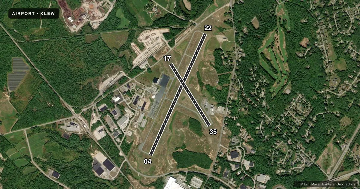
Runways & pattern
Full pagePattern entry · RWY 04
LEFT TRAFFIC| Runway | Heading (°M) | Length | Surface | Traffic |
|---|---|---|---|---|
| 04/22 | 7° / 187° | 5,001 ft | ASPH | Standard L |
| 17/35 | 131° / 311° | 2,750 ft | ASPH | Standard L |
Runway end performance
| End | TORA | TODA | ASDA | LDA | VGSI | Approach lights | Obstruction |
|---|---|---|---|---|---|---|---|
| 04 | — | — | — | — | PAPI 4-box left(3°) | MALSR | 100', trees, 4450' from thr, 450' R of cntrln, slope 42 |
| 22 | — | — | — | — | PAPI 4-box left(3.5°) | — | 62', trees, 849' from thr, 340' R of cntrln, slope 10 |
| 17 | — | — | — | — | — | — | 73', tree, 1508' from thr, 240' R of cntrln, slope 17 |
| 35 | — | — | — | — | — | — | 58', tree, 1077' from thr, 199' R of cntrln, slope 15 |
Declared distances in feet. TORA = takeoff run available, TODA = takeoff distance, ASDA = accelerate-stop, LDA = landing distance.
Airport sketch
Runways drawn to scale from FAA survey coordinates, rendered over satellite imagery. Not for navigation.
Approaches & charts
ILS · 1
Services on the field
Fuel grades, oxygen, maintenance, ramp storage and lighting — as declared to the FAA by the airport operator.
Fuel & services
- Fuel
- 100LLA1+
- Oxygen (bottled)
- Low pressure
- Oxygen (bulk)
- Not available
- Airframe repair
- Major
- Power plant repair
- Major
Ramp & ground
- Transient storage
- Tie-down
- Hangar
- Landing fee
- Yes
- Lighting schedule
- SEE RMK
- Beacon schedule
- SS-SR
- Beacon
- White / Green (civil land)(WG)
- Wind indicator
- Lighted
- Segmented circle
- Yes
Fuel & FBOs
Cheapest 100LL and Jet A on the field and nearby. Always confirm with the FBO before taxi.
Airport notes
Surface conditions, obstructions, local procedures, lighting outages and other notes published with each FAA cycle.
General notes
- BIRDS ON & INVOF ARPT.
- RWY 04 DSGND CALM WIND RWY.
- OCNL BLASTING IN PROG MON-SAT APRXLY 4800-5000 FT SW OF RWY 04 THR 1100-1500 DURG VFR CONDS ONLY.
- INTENSIVE HOP DLY FM 0500-2000. HEL TFC PAT 500 AGL, RIGHT TFC.
- ACFT DE-ICING AVBL.
- FOR CD WHEN APCH CLSD CTC BOSTON ARTCC AT 603-879-6859.
Lighting notes
- ACTVT MALSR RWY 04; REIL RWY 22; HIRL RWY 04/22 & MIRL RWY 17/35 - CTAF.
Fuel notes
- 100LLFOR FUEL OR SVCS AFT HRS CALL 207-784-6318.
Approach & departure obstructions
- 2213 FT POLE 100 FT FM RWY END, 375 FT R, +5 FT ROADWAY 0-200 FT FM RWY END 0-350 FT R.
Other notes
- THIS AIRPORT HAS BEEN SURVEYED BY THE NATIONAL GEODETIC SURVEY.
- EXISTED PRIOR TO 1959.
- CALL AHD FOR AVBLTY.
- MANAGERAUBURN CITY TRANSPORTATION DIR.
VFR map & nearby airports
VFR sectional. Tap any ICAO chip to open that airport.
Key facts · KLEW
Answer card- ICAO
- KLEW
- Name
- AUBURN/LEWISTON MUNI
- Location
- AUBURN/LEWISTON, MAINE
- Elevation
- 287.5 ft MSL
- Traffic pattern altitude
- 1,287.5 ft MSL (1,000 AGL)
- Control tower
- Non-towered (use CTAF)
- Total runways
- 2
- Longest runway
- 04/22 · 5,001 ft
- Published ILS approaches
- 1
- Published frequencies
- 5
- Magnetic variation
- 17°
- Current flight rules
- VFR
- Current wind
- 000° at 0 kt
- Favored runway now
- –
Auburn/Lewiston Muni sits in Auburn and serves the Lewiston area in Maine. Field elevation is 287.5 ft MSL. The airport has two asphalt runways. The longest is runway 04/22 at 5,001 ft. Runway 17/35 is 2,750 ft. There is no control tower. Use CTAF 122.8 for local traffic calls.
Runway 04 has the published ILS. The field also has MALSR on 04. Runway end identifier lights are on 22. High intensity lights are on 04 and 22. Medium intensity lights are on 17 and 35. Runway 04 is the calm wind runway. Published remarks also note a 13 ft pole near the departure end area for 04. A roadway is close to the runway end. That makes a close look at the departure path smart on the first visit.
Pattern altitude is not published. Use the standard 1,000 ft AGL for light piston traffic unless the current FAA Chart Supplement says otherwise. Auburn-Lewiston Airport is the on-field FBO. It carries 100LL, Jet A and Jet A Prist. The airport also notes de-icing availability. Birds are reported in and around the airport. Occasional blasting can happen southwest of runway 04 during VFR conditions from Monday through Saturday between 1100 and 1500. Call ahead for availability before you go.