METAR & TAF KCVG
Current METAR
Observed 12:52Z
KCVG 271252Z 00000KT 8SM FEW300 23/21 A2995 RMK AO2 SLP130 T02280211
- Wind
- 000° @ 0 kt
- Visibility
- 8 SM
- Temp / Dew
- 23°C / 21°C
- Altimeter
- 29.95 inHg
- Clouds
- FEW
- Density alt
- 2,034 ft
- Ceiling
- Unlimited
- Rules
- VFR
Airport info & contacts
Manager on record, flight service, ARTCC, attendance schedule and pattern altitude — published by the FAA and refreshed every 28 days.
Location
- From city
- 8 NM SW
- VFR sectional
- CINCINNATI
- ARTCC
- ZID · INDIANAPOLIS
- NOTAM facility
- CVG (NOTAM-D)
Airport manager
- Name
- LARRY KRAUTER
- Phone
- 859-767-3151
- Address
- PO BOX 752000, CINCINNATI OH 45275-2000
Flight service · Hours
- FSS LOU
- LOUISVILLE1-800-WX-BRIEF
- Attendance
- ALL
Frequencies
Tap any row to copy the frequency to your clipboard.
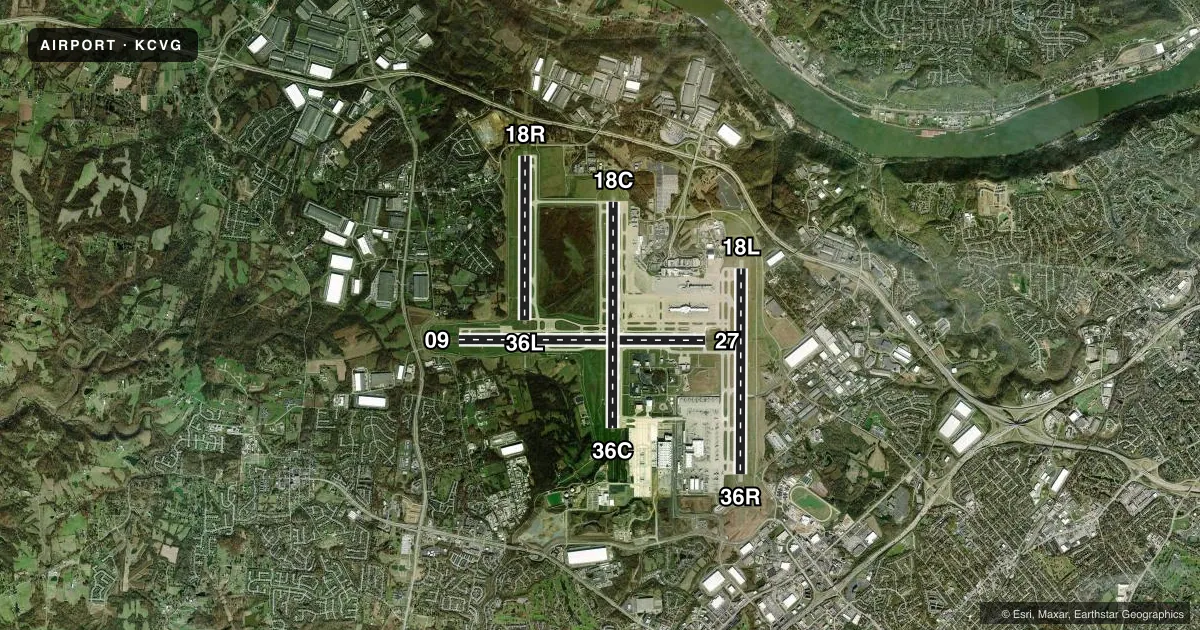
Runways & pattern
Full pagePattern entry · RWY 09
LEFT TRAFFIC| Runway | Heading (°M) | Length | Surface | Traffic |
|---|---|---|---|---|
| 09/27 | 84° / 264° | 12,001 ft | ASPH-CONC | Standard L |
| 18C/36C | 174° / 354° | 11,000 ft | ASPH-CONC | Standard L |
| 18L/36R | 174° / 354° | 10,000 ft | CONC | Standard L |
| 18R/36L | 174° / 354° | 8,000 ft | CONC | Standard L |
Runway end performance
| End | TORA | TODA | ASDA | LDA | VGSI | Approach lights | Obstruction |
|---|---|---|---|---|---|---|---|
| 09 | 12,000' | 12,000' | 11,640' | 11,640' | PAPI 4-box left(3°) | MALSR | — |
| 27 | 12,000' | 12,000' | 12,000' | 12,000' | PAPI 4-box left(3°) | MALSR | — |
| 18C | — | — | — | — | PAPI 4-box right(3°) | MALSR | — |
| 36C | — | — | — | — | PAPI 4-box left(3°) | ALSF2 | — |
| 18L | — | — | — | — | PAPI 4-box left(3°) | MALSR | — |
| 36R | — | — | — | — | PAPI 4-box right(3°) | ALSF2 | — |
| 18R | — | — | — | — | — | ALSF2 | — |
| 36L | — | — | — | — | — | ALSF2 | — |
Declared distances in feet. TORA = takeoff run available, TODA = takeoff distance, ASDA = accelerate-stop, LDA = landing distance.
Airport sketch
Runways drawn to scale from FAA survey coordinates, rendered over satellite imagery. Not for navigation.
Approaches & charts
ILS · 8
Services on the field
Fuel grades, oxygen, maintenance, ramp storage and lighting — as declared to the FAA by the airport operator.
Fuel & services
- Fuel
- 100LLA
- Airframe repair
- Major
- Power plant repair
- Major
- Other services
- AFRT,AVNCS,CARGO,CHTR
Ramp & ground
- Transient storage
- Tie-down
- Hangar
- Landing fee
- No fee published
- Customs
- Not available
- Beacon schedule
- SS-SR
- Beacon
- White / Green (civil land)(WG)
- Wind indicator
- Lighted
- Segmented circle
- No
Fuel & FBOs
Cheapest 100LL and Jet A on the field and nearby. Always confirm with the FBO before taxi.
Airport notes
Surface conditions, obstructions, local procedures, lighting outages and other notes published with each FAA cycle.
General notes
- NOISE SENS AREA N & S OF ARPT; RWY ASGN 2200-0700 BASED ON NOISE ABATEMENT.
- SUCCESSIVE OR SIMUL DEP FM RWY 18L, 18C, 36L, 36C & 36R APVD WITH COURSE DVRG BGN NO FURTHER THAN 2 MI FM EOR DUE TO NOISE ABATEMENT.
- TWYS RSTRD TO 15 MPH OR LESS WITH WINGSPAN 214 FT OR MORE.
- BIRDS ON & INVOF THE ARPT.
- RAMP CTL: RAMP 1N / 1S TXL & RAMP 2N / 2S TXL - 130.90, RAMP 3 TXL & N TXL - 130.375; DHL RAMP CTL: 129.475; AMZ RAMP CTL: 130.5.
Runway surface & condition
- 09/27PCR VALUE: 922/R/B/W/T
- 18C/36CPCR VALUE: 741/R/A/W/T
- 18L/36RPCR VALUE: 790/R/A/W/T
- 18R/36LPCR VALUE: 778/R/A/W/T
- 09/27W 4200 FT & E 750 FT CONC; REMAINDER ASPH OVERLAY.
- 18R/36LCLSD TO PAX ACFT WITH WINGSPAN GTR THAN 140 FT.
Other notes
- EXISTED PRIOR TO 1959.
- ARFF INDEX E AVBL UPON REQ.
VFR map & nearby airports
VFR sectional. Tap any ICAO chip to open that airport.
Key facts · KCVG
Answer card- ICAO
- KCVG
- Name
- CINCINNATI/NORTHERN KENTUCKY INTL
- Location
- COVINGTON, KENTUCKY
- Elevation
- 896.1 ft MSL
- Traffic pattern altitude
- 1,896.1 ft MSL (1,000 AGL)
- Control tower
- Towered · 24
- Total runways
- 4
- Longest runway
- 09/27 · 12,001 ft
- Published ILS approaches
- 8
- Published frequencies
- 20
- Magnetic variation
- 6°
- Current flight rules
- VFR
- Current wind
- 000° at 0 kt
- Favored runway now
- –
Cincinnati/Northern Kentucky Intl is in Covington, Kentucky. The field elevation is 896.1 ft MSL. It has four runways. The longest is 12,001 ft. The tower is open 24 hours. Eight ILS approaches are published for the field. Runway ends include 09, 18C, 18L, 18R, 27, 36C, 36L and 36R.
For pattern work, the published pattern altitude is not listed in the facts. Use the current Chart Supplement for the exact traffic pattern altitude before you go. PremierFBO is on the field. It carries 100LL, Jet A and Jet A Prist. Call (859) 534-4301 for current service details.
This is a busy Class B airport with ramp control areas in use. The remarks also show noise-sensitive areas north and south of the airport. Runway assignments from 2200 to 0700 follow noise abatement procedures. Successive or simultaneous departures are approved from several runway ends when course divergence starts within 2 miles of the runway end. Birds are present on and near the airport. Taxiways are restricted to 15 mph or less for aircraft with wingspan 214 feet or more. If you are planning a first visit, study the current Chart Supplement and be ready for a controlled, high-traffic environment.