METAR & TAF KCMH
Current METAR
Observed 19:51Z
KCMH 271951Z 21009KT 9SM SCT160 BKN250 28/20 A2985 RMK AO2 SLP100 T02830200
- Wind
- 210° @ 9 kt
- Visibility
- 9 SM
- Temp / Dew
- 28°C / 20°C
- Altimeter
- 29.85 inHg
- Clouds
- BKN
- Density alt
- 2,657 ft
- Ceiling
- 25,000 ft AGL
- Rules
- VFR
Airport info & contacts
Manager on record, flight service, ARTCC, attendance schedule and pattern altitude — published by the FAA and refreshed every 28 days.
Location
- From city
- 6 NM E
- VFR sectional
- CINCINNATI
- ARTCC
- ZID · INDIANAPOLIS
- NOTAM facility
- CMH (NOTAM-D)
Airport manager
- Name
- DAREN A GRIFFIN
- Phone
- 614-239-4004
- Address
- COLUMBUS REGIONAL AIRPORT AUTHORITY, 4600 INTERNATIONAL GATEWAY, COLUMBUS OH 43219
Flight service · Hours
- FSS DAY
- DAYTON1-800-WX-BRIEF
- Attendance
- ALL
Frequencies
Tap any row to copy the frequency to your clipboard.
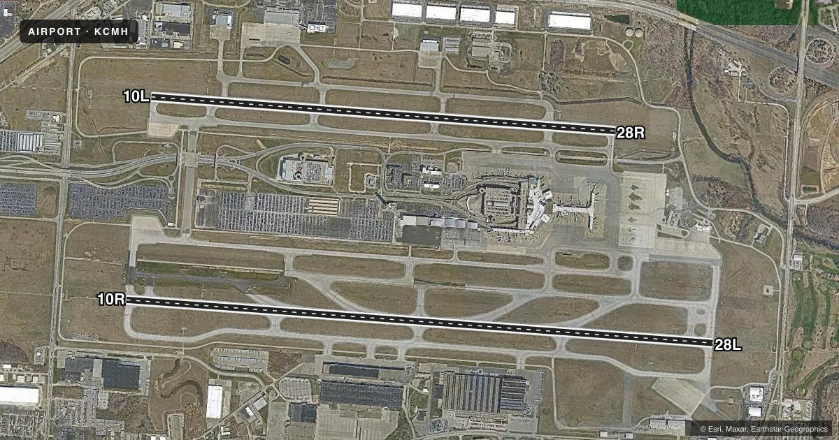
Runways & pattern
Full pagePattern entry · RWY 28L
LEFT TRAFFIC| Runway | Heading (°M) | Length | Surface | Traffic |
|---|---|---|---|---|
| 10R/28LFavored | 87° / 267° | 10,114 ft | ASPH | Standard L |
| 10L/28R | 87° / 267° | 8,000 ft | ASPH | Standard L |
Runway end performance
| End | TORA | TODA | ASDA | LDA | VGSI | Approach lights | Obstruction |
|---|---|---|---|---|---|---|---|
| 10R | 10,114' | 10,114' | 10,114' | 10,114' | PAPI 4-box left(3°) | MALSR | — |
| 28L | 10,114' | 10,114' | 10,114' | 10,114' | PAPI 4-box left(3°) | MALSR | — |
| 10L | 8,000' | 8,000' | 8,000' | 8,000' | PAPI 4-box left(3°) | MALSR | — |
| 28R | 8,000' | 8,000' | 8,000' | 8,000' | PAPI 4-box right(3°) | MALSR | — |
Declared distances in feet. TORA = takeoff run available, TODA = takeoff distance, ASDA = accelerate-stop, LDA = landing distance.
Airport sketch
Runways drawn to scale from FAA survey coordinates, rendered over satellite imagery. Not for navigation.
Approaches & charts
ILS · 4
Services on the field
Fuel grades, oxygen, maintenance, ramp storage and lighting — as declared to the FAA by the airport operator.
Fuel & services
- Fuel
- 100A1+
- Oxygen (bottled)
- HIGH/LOW
- Oxygen (bulk)
- Not available
- Airframe repair
- Major
- Power plant repair
- Major
- Other services
- AFRT,AMB,AVNCS,CARGO,CHTR,INSTR,RNTL,SALES
Ramp & ground
- Transient storage
- Tie-down
- Hangar
- Landing fee
- Yes
- Customs
- Not available
- Beacon schedule
- SS-SR
- Beacon
- White / Green (civil land)(WG)
- Wind indicator
- Yes
- Segmented circle
- No
Fuel & FBOs
Cheapest 100LL and Jet A on the field and nearby. Always confirm with the FBO before taxi.
Airport notes
Surface conditions, obstructions, local procedures, lighting outages and other notes published with each FAA cycle.
General notes
- MODEL ACFT TFC WITHIN A 1 NM RDS OF A POINT 8 NM ON A 010 DEG BRG FM THE ARPT; SFC - 5000 FT AGL; SR-SS DLY.
- BIRDS INVOF ARPT.
- TWY D-5 PAVEMENT (NORTH OF TWY D) IS RSTRD TO ACFT WITH WINGSPAN LESS THAN 79 FT.
- BE ALERT: RY 10L/28R RESTRICTIONS ON STAGE I & II TURBOJET ACFT 2200-0800 & ON STAGE III TURBOJET ACFT 2200-0700. PRACTICE APCHS FOR HIGH NOISE LEVEL TYPE ACFT INCLUDING NON-STAGE III MIL JET ACFT SHALL NOT BE APPROVED UNLESS RY 10R/28L IS IN USE & THE APCH TERMINATES IN A FULL STOP TAXI-BACK OPN.
- ALL SURFACES AROUND TERMINAL; NORTH OF TWY 'D' & SOUTH OF TWY 'E' ARE NON-MOVEMENT AREAS.
- NOISE BARRIER LOCATED AT SE SIDE OF AIRFIELD RESTRICTED TO ACFT WITH WINGSPAN LESS THAN 79 FT.
- TO REQ LDG RIGHTS CTC US CUSTOMS BETWEEN 1230-0300Z, MON-FRI AT 614-497-1865.
- FLIGHT NOTIFICATION SERVICE (ADCUS) AVBL.
- TWY F1 RSTRD TO AIRCRAFT WITH WINGSPAN LESS THAN 120 FT.
- TWYS R2, R3, R4, R5 AND R6 RSTRD TO WINGSPAN LESS THAN 118 FT.
- TWY R1 RSTRD TO ACFT WITH WINGSPAN LESS THAN 79 FT.
- TAXILANE CONCOURSE A BTN TWY D3 AND TWY D4 CLSD TO ACFT WINGSPAN MORE THAN 130 FT.
- TAXILANE CONCOURSE C BTN TWY J AND TWY K CLSD TO ACFT WINGSPAN MORE THAN 135 FT.
- HOLD PAD FOR RWY 28L RSTRD TO ACFT WITH WINGSPAN LESS THAN 118 FT.
- PILOTS CONDUCTING EFVS OPS; BE AWARE LED ALS IN USE RWY 28L.
Runway surface & condition
- 10L/28RPCR VALUE: 557/F/A/X/T
- 10R/28LPCR VALUE: 778/F/A/X/T
Approach & departure obstructions
- 10LRWY 10L BLAST PAD 200 FT X 200 FT.
- 28RRWY 28R BLAST PAD 200 FT X 200 FT.
Other notes
- HEL ASP: PRVDD INGRESS/EGRESS RTES USED ARE AS DIRECTED BY PORT COLUMBUS ATCT.
- TO REQUEST LANDING RIGHTS CTC US CUSTOMS BTN 0730-2200 MON-FRI AT 614-497-1865.
VFR map & nearby airports
VFR sectional. Tap any ICAO chip to open that airport.
Key facts · KCMH
Answer card- ICAO
- KCMH
- Name
- JOHN GLENN COLUMBUS INTL
- Location
- COLUMBUS, OHIO
- Elevation
- 815 ft MSL
- Traffic pattern altitude
- 1,815 ft MSL (1,000 AGL)
- Control tower
- Towered · 24
- Total runways
- 2
- Longest runway
- 10R/28L · 10,114 ft
- Published ILS approaches
- 4
- Published frequencies
- 19
- Magnetic variation
- 7°
- Current flight rules
- VFR
- Current wind
- 210° at 9 kt
- Favored runway now
- RWY 28L
John Glenn Columbus Intl is in Columbus, Ohio. Field elevation is 815 ft MSL. The airport has two asphalt runways. The longest is 10,114 ft on 10R/28L. The tower is open 24 hours. Four ILS approaches are published for the runway ends at 10L, 10R, 28L and 28R.
Pattern altitude is not published in the facts. Use the current FAA Chart Supplement before you go. The airport sits in Class C airspace. That means you should be ready for a busy arrival flow and standard ATC coordination. The published remarks also call out several wing-span limits on taxiways and hold areas. That matters for larger aircraft. The southeast noise barrier, Taxiway R1 and the 28L hold pad all have published wingspan restrictions. Helicopter routes are also directed by the tower.
On the field, Signature Aviation carries 100LL and Jet A. Lane Aviation carries 100LL, Jet A and Jet A Prist. Flight notification service is available. There is also an LED approach lighting system in use on runway 28L. Crews using enhanced vision equipment should brief that before arrival.