METAR & TAF KBGM
Current METAR
Observed 12:53Z
KBGM 271253Z AUTO 28004KT 10SM CLR 19/17 A2989 RMK AO2 SLP114 T01940172
- Wind
- 280° @ 4 kt
- Visibility
- 10 SM
- Temp / Dew
- 19°C / 17°C
- Altimeter
- 29.89 inHg
- Clouds
- CLR
- Density alt
- 2,545 ft
- Ceiling
- Unlimited
- Rules
- VFR
Airport info & contacts
Manager on record, flight service, ARTCC, attendance schedule and pattern altitude — published by the FAA and refreshed every 28 days.
Location
- From city
- 7 NM N
- VFR sectional
- NEW YORK
- Pattern altitude
- 800 ft AGL · 2,436 ft MSL
- ARTCC
- ZNY · NEW YORK
- NOTAM facility
- BGM (NOTAM-D)
Airport manager
- Name
- MARK HEEFNER
- Phone
- 607-763-4471
- Address
- 2534 AIRPORT ROAD, #16, JOHNSON CITY NY 13790
Flight service · Hours
- FSS BUF
- BUFFALO1-800-WX-BRIEF
- Attendance
- ALL
Frequencies
Tap any row to copy the frequency to your clipboard.
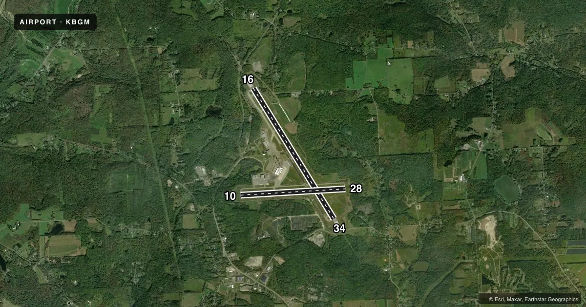
Runways & pattern
Full pagePattern entry · RWY 28
LEFT TRAFFIC| Runway | Heading (°M) | Length | Surface | Traffic |
|---|---|---|---|---|
| 16/34 | 136° / 316° | 7,305 ft | ASPH | Standard L |
| 10/28Favored | 74° / 254° | 5,001 ft | ASPH | Standard L |
Runway end performance
| End | TORA | TODA | ASDA | LDA | VGSI | Approach lights | Obstruction |
|---|---|---|---|---|---|---|---|
| 16 | 7,305' | 7,305' | 7,305' | 6,905' | PAPI 2-box left(3°) | MALSR | 7', ant, 225' from thr, 250' R of cntrln, slope 3 |
| 34 | 7,305' | 7,305' | 7,305' | 7,100' | PAPI 2-box left(3°) | MALSR | — |
| 10 | 5,001' | 5,001' | 5,001' | 5,001' | VASI 4-box left(3°) | — | — |
| 28 | 5,001' | 5,001' | 5,001' | 5,001' | VASI 4-box left(3°) | — | — |
Declared distances in feet. TORA = takeoff run available, TODA = takeoff distance, ASDA = accelerate-stop, LDA = landing distance.
Airport sketch
Runways drawn to scale from FAA survey coordinates, rendered over satellite imagery. Not for navigation.
Approaches & charts
ILS · 2
Services on the field
Fuel grades, oxygen, maintenance, ramp storage and lighting — as declared to the FAA by the airport operator.
Fuel & services
- Fuel
- 100LLA
- Oxygen (bottled)
- HIGH/LOW
- Oxygen (bulk)
- Not available
- Airframe repair
- Minor
- Power plant repair
- Minor
- Other services
- AMB,AVNCS,CARGO,CHTR,INSTR,RNTL,SALES
Ramp & ground
- Transient storage
- Tie-down
- Hangar
- Landing fee
- Yes
- Customs
- Not available
- Lighting schedule
- SEE RMK
- Beacon schedule
- SEE RMK
- Beacon
- White / Green (civil land)(WG)
- Wind indicator
- Lighted
- Segmented circle
- No
Fuel & FBOs
Cheapest 100LL and Jet A on the field and nearby. Always confirm with the FBO before taxi.
Airport notes
Surface conditions, obstructions, local procedures, lighting outages and other notes published with each FAA cycle.
General notes
- ATCT UNABLE TO SEE HARD SFC S OF FBO HANGAR.
- EXTSV GLDR ACT 10 NM SW OF ARPT.
- BIRD ACT ON & INVOF ARPT.
- LGTD STRUCTURE 118 FT AGL 2000 FT S OF AER 10.
- FOR CD IF UNA TO CTC ON FSS FREQ, CTC NEW YORK ARTCC AT 631-468-1425.
- PILOTS CONDUCTING EFVS OPS; BE AWARE LED ALS IN USE RWY 16 & RWY 34.
Lighting notes
- DUSK-DAWN.
- WHEN ATCT CLSD ACTVT MALSR RWY 16 & 34; HIRL RWY 16/34; MIRL RWY 10/28; TWY LGTS - CTAF.
Runway surface & condition
- 10/28PCR VALUE: 350/F/D/X/T
- 16/34PCR VALUE: 740/F/D/X/T
- 10/28RWY 10 TKOFS & LDGS NA WHEN ATCT CLSD.
- 16/34HLDG PSN SIGNS FOR RWY 16/34 RESIDE AFT THE HOLD LINE. WHEN HLDG ENSURE ALL PARTS OF THE ACFT RMN BHND THE HOLD LN.
- H1HELIPAD LCTD AT INT OF TWY L & THE W APRON.
Arresting gear
- 16_EMASENGINEERED MATERIALS ARRESTING SYSTEM (EMAS) 315 FT IN LENGTH BY 161 FT WIDTH LCTD AT DER 16.
- 34_EMASENGINEERED MATERIALS ARRESTING SYSTEM (EMAS) 311 FT IN LENGTH BY 161 FT WIDTH LCTD AT DER 34.
Other notes
- PPR 12 HRS FOR UNSKED ACR OPS WITH MORE THAN 9 PAX SEATS 2300-0600 CALL AMGR 607-763-4474. ARFF AVBL 0530-0000 AND/OR TIL 15 MIN AFT THE LAST SKED ACR OPN.
- LNDG FEE FOR MULTI-ENGINE & TURBINE ACFT OVER 4000 LBS. US CUSTOMS USER FEE ARPT.
- 1FBO SVCS AVBL 0500-2000 SUN-SAT. AFT HRS FBO SVCS CTC 607-763-4474.
VFR map & nearby airports
VFR sectional. Tap any ICAO chip to open that airport.
Key facts · KBGM
Answer card- ICAO
- KBGM
- Name
- GREATER BINGHAMTON/EDWIN A LINK FLD
- Location
- BINGHAMTON, NEW YORK
- Elevation
- 1,635.6 ft MSL
- Traffic pattern altitude
- 2,435.6 ft MSL (800 AGL)
- Control tower
- Towered · 0600-0000
- Total runways
- 2
- Longest runway
- 16/34 · 7,305 ft
- Published ILS approaches
- 2
- Published frequencies
- 15
- Magnetic variation
- 12°
- Current flight rules
- VFR
- Current wind
- 280° at 4 kt
- Favored runway now
- RWY 28
KBGM is in Binghamton, New York. The field elevation is 1,635.6 ft MSL. There are two asphalt runways. The longest is 7,305 ft on runway 16/34. Runway 10/28 is 5,001 ft. The tower is open 0600-0000. Two ILS approaches are published. Pattern altitude is 800 ft AGL, which is 2,435.6 ft MSL.
BGM Aviation Services is the on-field FBO. It carries 100LL, Jet A and Jet A Prist. Call 607-763-4474 for service or after-hours arrangements. The published remarks matter here. Bird activity is reported on and near the airport. Glider activity is also noted 10 NM southwest of the field. LED approach lighting is in use on runways 16 and 34, which matters for EFVS work. The airport beacon runs from dusk to dawn.
A first-time pilot should pay attention to the runway and tower notes. Takeoffs and landings on runway 10 are not authorized when the tower is closed. The tower cannot see the hard surface south of the FBO hangar. Holding position signs for runway 16/34 are placed after the hold line, so keep the aircraft fully behind the line when holding. This is a customs user fee airport. There is also a landing fee for multi-engine and turbine aircraft over 4,000 lb. Check the current FAA Chart Supplement for any current noise or curfew restrictions before flying in.