METAR & TAF KAVP
Current METAR
Observed 10:54Z
KAVP 271054Z 00000KT 10SM CLR 16/15 A2988 RMK AO2 SLP112 T01610150
- Wind
- 000° @ 0 kt
- Visibility
- 10 SM
- Temp / Dew
- 16°C / 15°C
- Altimeter
- 29.88 inHg
- Clouds
- CLR
- Density alt
- 1,362 ft
- Ceiling
- Unlimited
- Rules
- VFR
Airport info & contacts
Manager on record, flight service, ARTCC, attendance schedule and pattern altitude — published by the FAA and refreshed every 28 days.
Location
- From city
- 5 NM SW
- VFR sectional
- NEW YORK
- ARTCC
- ZNY · NEW YORK
- NOTAM facility
- AVP (NOTAM-D)
Airport manager
- Name
- STEPHEN MYKULYN
- Phone
- 570-602-2000
- Address
- 100 TERMINAL DRIVE, AVOCA PA 18641
Flight service · Hours
- FSS IPT
- WILLIAMSPORT1-800-WX-BRIEF
- Attendance
- ALL
Frequencies
Tap any row to copy the frequency to your clipboard.
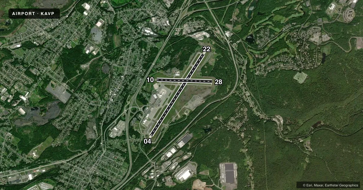
Runways & pattern
Full pagePattern entry · RWY 04
LEFT TRAFFIC| Runway | Heading (°M) | Length | Surface | Traffic |
|---|---|---|---|---|
| 04/22 | 22° / 202° | 7,502 ft | ASPH | 22 R |
| 10/28 | 81° / 261° | 4,300 ft | ASPH | 10 R · 28 R |
Runway end performance
| End | TORA | TODA | ASDA | LDA | VGSI | Approach lights | Obstruction |
|---|---|---|---|---|---|---|---|
| 04 | 7,502' | 7,502' | 7,502' | 7,502' | PAPI 4-box right(3°) | MALSR | — |
| 22 | 7,502' | 7,502' | 7,502' | 7,502' | VASI 4-box left(3°) | — | 112', trees, 4567' from thr, 723' R of cntrln, slope 39 |
| 10 | 4,300' | 4,300' | 4,300' | 4,300' | PAPI 2-box left(3°) | — | — |
| 28 | 4,300' | 4,300' | 4,300' | 4,300' | — | — | 21', trees, 348' from thr, 234' R of cntrln, slope 7 |
Declared distances in feet. TORA = takeoff run available, TODA = takeoff distance, ASDA = accelerate-stop, LDA = landing distance.
Airport sketch
Runways drawn to scale from FAA survey coordinates, rendered over satellite imagery. Not for navigation.
Approaches & charts
ILS · 2
Services on the field
Fuel grades, oxygen, maintenance, ramp storage and lighting — as declared to the FAA by the airport operator.
Fuel & services
- Fuel
- 100LLA
- Oxygen (bottled)
- Low pressure
- Oxygen (bulk)
- Low pressure
- Airframe repair
- Major
- Power plant repair
- Minor
- Other services
- AFRT,AVNCS,CARGO,CHTR,INSTR,RNTL
Ramp & ground
- Transient storage
- Tie-down
- Hangar
- Landing fee
- Yes
- Customs
- Not available
- Beacon schedule
- SS-SR
- Beacon
- White / Green (civil land)(WG)
- Wind indicator
- Lighted
- Segmented circle
- No
Fuel & FBOs
Cheapest 100LL and Jet A on the field and nearby. Always confirm with the FBO before taxi.
Airport notes
Surface conditions, obstructions, local procedures, lighting outages and other notes published with each FAA cycle.
General notes
- DEER & BIRDS ON & INVOF ARPT.
- RY 28 UNLGTD HIGH TERRAIN TREES: 1155 FT MSL .91 MI EAST AER 28; 1463 FT MSL 1.49 MI EAST-SOUTHEAST AER 28; 1667 FT MSL 2.25 MI EAST AER 28; 1920 FT MSL 2.84 MI EAST AER 28.
- UNLGTD TOWER 1130 FT MSL (20 FT AGL) 1.3 MI EAST AER 28; UNLGTD TOWER 1463 FT MSL (20 FT AGL) 1.7 MI EAST AER 28; UNLGTD TOWER 1652 FT MSL (20 FT AGL) 2.4 MI EAST AER 28.
- FOR FBO SERVICE 0000-0500 LOCAL M-F AND 2100-0000 LOCAL SAT-SUN CALL (570) 457-4485.
Runway surface & condition
- 04/22PCR VALUE: 770/F/C/X/T
- 10/28PCR VALUE: 480/F/C/X/T
- 04/22PRECIPITOUS DROP-OFF EACH RY END.
Arresting gear
- 04_EMASENGINEERED MATERIAL ARRESTING SYSTEM (EMAS) 324 FT IN LENGTH BY 170 FT IN WIDTH LCTD 50 FT OFF DER 04.
- 22_EMASENGINEERED MATERIAL ARRESTING SYSTEM (EMAS) 162 FT IN LENGTH BY 170 FT IN WIDTH LCTD 35 FT OFF DER 22.
Other notes
- EXISTED PRIOR TO REQMT FOR AIRSPACE DETER.
- INDEX "C" ARFF EQUIPMENT AVAILABLE UPON REQUEST CALL 570-602-2040.
VFR map & nearby airports
VFR sectional. Tap any ICAO chip to open that airport.
Key facts · KAVP
Answer card- ICAO
- KAVP
- Name
- WILKES-BARRE/SCRANTON INTL
- Location
- WILKES-BARRE/SCRANTON, PENNSYLVANIA
- Elevation
- 961.7 ft MSL
- Traffic pattern altitude
- 1,961.7 ft MSL (1,000 AGL)
- Control tower
- Towered · 24
- Total runways
- 2
- Longest runway
- 04/22 · 7,502 ft
- Published ILS approaches
- 2
- Published frequencies
- 13
- Magnetic variation
- 11°
- Current flight rules
- VFR
- Current wind
- 000° at 0 kt
- Favored runway now
- –
Wilkes-Barre/Scranton Intl is in Wilkes-Barre/Scranton, Pennsylvania. Field elevation is 961.7 ft MSL. The airport has 2 runways. The longest is runway 04/22 at 7,502 ft. The tower is open 24 hours. Two ILS approaches are published for runway ends 04 and 22. Pattern altitude is not published in the facts, so use the standard 1,000 ft AGL for light piston operations unless the current Chart Supplement says otherwise.
Ascension FBO is on the field. It carries 100LL, Jet A and Jet A Prist. For FBO service from 0000 to 0500 local Monday through Friday. Also from 2100 to 0000 local Saturday and Sunday. Call the FBO directly at (570) 457-4485. The airport remarks also note deer and birds in and around the field. Runway 28 has unlighted terrain and towers on the approach side. That matters if you are planning a visual arrival there.
Runway 22 has an EMAS beyond the departure end. Runway 04 also has EMAS beyond the departure end. The field elevation is moderate. The airport sits in a busy part of northeastern Pennsylvania. Expect controlled-airport procedures and stay sharp on runway assignment and approach setup. Check the current Chart Supplement for any noise or operational notes before you go.