METAR & TAF KSFF
Current METAR
Observed 16:53Z
KSFF 271653Z 28005KT 10SM CLR 23/06 A3007 RMK AO2 SLP169 T02280061
- Wind
- 280° @ 5 kt
- Visibility
- 10 SM
- Temp / Dew
- 23°C / 6°C
- Altimeter
- 30.07 inHg
- Clouds
- CLR
- Density alt
- 3,200 ft
- Ceiling
- Unlimited
- Rules
- VFR
Airport info & contacts
Manager on record, flight service, ARTCC, attendance schedule and pattern altitude — published by the FAA and refreshed every 28 days.
Location
- From city
- 4 NM NE
- VFR sectional
- SEATTLE
- ARTCC
- ZSE · SEATTLE
- NOTAM facility
- SFF (NOTAM-D)
Airport manager
- Name
- DAVID HARING
- Phone
- 509-455-6455
- Address
- 9000 W. AIRPORT DRIVE, SUITE 204, SPOKANE WA 99224
Flight service · Hours
- FSS SEA
- SEATTLE1-800-WX-BRIEF
- Attendance
- 0600-2000
Frequencies
Tap any row to copy the frequency to your clipboard.
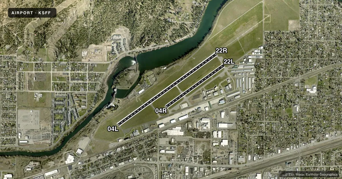
Runways & pattern
Full pagePattern entry · RWY 22R
RIGHT TRAFFIC| Runway | Heading (°M) | Length | Surface | Traffic |
|---|---|---|---|---|
| 04L/22RFavored | 38° / 218° | 4,499 ft | CONC | 22R R |
| 04R/22L | 38° / 218° | 2,650 ft | ASPH | 04R R |
Runway end performance
| End | TORA | TODA | ASDA | LDA | VGSI | Approach lights | Obstruction |
|---|---|---|---|---|---|---|---|
| 04L | 4,499' | 4,499' | 4,499' | 4,499' | VASI 2-box left(3°) | — | — |
| 22R | 4,499' | 4,499' | 4,499' | 4,499' | VASI 2-box right(3.5°) | MALSR | 72', tree, 2045' from thr, 1220' R of cntrln, slope 25 |
| 04R | 2,650' | 2,650' | 2,650' | 2,650' | — | — | — |
| 22L | 2,650' | 2,650' | 2,650' | 2,650' | PAPI 4-box left(3.8°) | — | 91', tree, 1855' from thr, 280' R of cntrln, slope 18 |
Declared distances in feet. TORA = takeoff run available, TODA = takeoff distance, ASDA = accelerate-stop, LDA = landing distance.
Airport sketch
Runways drawn to scale from FAA survey coordinates, rendered over satellite imagery. Not for navigation.
Approaches & charts
ILS · 1
Services on the field
Fuel grades, oxygen, maintenance, ramp storage and lighting — as declared to the FAA by the airport operator.
Fuel & services
- Fuel
- 100LLA1+
- Oxygen (bottled)
- HIGH/LOW
- Airframe repair
- Major
- Power plant repair
- Major
- Other services
- AMB,AVNCS,CHTR,INSTR,RNTL,SALES
Ramp & ground
- Transient storage
- Tie-down
- Landing fee
- No fee published
- Customs
- Not available
- Lighting schedule
- SEE RMK
- Beacon schedule
- SS-SR
- Beacon
- White / Green (civil land)(WG)
- Wind indicator
- Lighted
- Segmented circle
- Yes
Fuel & FBOs
Cheapest 100LL and Jet A on the field and nearby. Always confirm with the FBO before taxi.
Airport notes
Surface conditions, obstructions, local procedures, lighting outages and other notes published with each FAA cycle.
General notes
- <BIRD HAZARD--SEE SPECIAL NOTICE FOR WASHINGTON IN AIM PART 3A.
- TWR UNABLE TO PRVD ATC SVC ON PERIMETER TWY DUE TO MOVEMENT OF UNCONTROLLED GROUND TFC.
- EXTENSIVE BOATING IN AREA OF WATER RY.
- WATER LVL ON RIVER MAY BE LWRD BY CORPS OF ENGR. WATER AREA ADJ TO ARPT NOT CTLD OR MNTND BY ARPT. WATERWAY ELEV 1910 ESTD.
- (E94) SAWRS.
- WATERFOWL AND BIRDS ON & INVOF ARPT.
- ACFT WITH TAIL HEIGHTS OVER 20 FT MUST CTC ATCT PRIOR TO TAXI.
- PPR FOR ROTORWING ACFT CONCDUCTING HOVER OPS ABOVE 10 FT AGL IN NON-MOVEMENT AREA CTC ATCT.
- PORTIONS OF TWY B NOT VISIBLE FM ATCT.
- FOR CD IF UNA TO CTC ON FSS FREQ, CTC SPOKANE APPROACH AT 509-742-2522.
- COLD TEMPERATURE AIRPORT. ALTITUDE CORRECTION REQUIRED AT OR BELOW -15C.
Lighting notes
- WHEN ATCT CLSD ACTVT MIRL RY 04L/22R, MALSR RY 22R AND REIL RY 04L - CTAF. VASI RY 04L & VASI RY 22R OPER CONTINUOUSLY. PAPI RY 22L OPER SR-SS.
Runway surface & condition
- 03W/21WWATER RWY ADZY SVC ONLY AREA NOT VSB FM TWR. CTC FELTS TWR 132.5 FOR TFC DATA.
Approach & departure obstructions
- 22LPAPI UNUSBL BYD 5 DEGS RIGHT SIDE OF CNTRLN.
Other notes
- CONSTRUCTED PRIOR TO MAY 1959.
VFR map & nearby airports
VFR sectional. Tap any ICAO chip to open that airport.
Key facts · KSFF
Answer card- ICAO
- KSFF
- Name
- FELTS FLD
- Location
- SPOKANE, WASHINGTON
- Elevation
- 1,956.7 ft MSL
- Traffic pattern altitude
- 2,956.7 ft MSL (1,000 AGL)
- Control tower
- Towered · 0600-2000
- Total runways
- 2
- Longest runway
- 04L/22R · 4,499 ft
- Published ILS approaches
- 1
- Published frequencies
- 9
- Magnetic variation
- 16°
- Current flight rules
- VFR
- Current wind
- 280° at 5 kt
- Favored runway now
- RWY 22R
Felts Fld sits in Spokane, Washington. Field elevation is 1,956.7 ft MSL. The airport has two runways. The longest is 4,499 ft on 04L/22R. The tower is open 0600-2000. One ILS is published for runway 22R. Pattern altitude is not published, so use standard 1,000 ft AGL for light piston traffic unless the current Chart Supplement says otherwise.
Aero Center is on the field. It carries 100LL, Jet A and Jet A Prist. Call (509) 534-7371 for current service details before you go. The field has a mix of asphalt and concrete runways. Runway 04L/22R is the longer concrete strip. Runway 04R/22L is 2,650 ft asphalt.
There are a few operational items worth planning for. Aircraft with tail heights over 20 ft must contact the tower before taxi. The tower cannot provide ATC service on the perimeter taxiway because of uncontrolled ground traffic. Portions of taxiway B are not visible from the tower. Waterfowl and birds are reported on and near the airport. Cold weather can also matter here. Altitude correction is required at or below minus 15 degrees Celsius. If you need clearance delivery and cannot reach FSS, Spokane Approach can be contacted at 509-742-2522.