METAR & TAF KRST
Current METAR
Observed 19:54Z
KRST 271954Z 29015KT 6SM HZ CLR 34/21 A2973 RMK AO2 SLP053 T03390206
- Wind
- 290° @ 15 kt
- Visibility
- 6 SM
- Temp / Dew
- 34°C / 21°C
- Altimeter
- 29.73 inHg
- Clouds
- CLR
- Density alt
- 4,149 ft
- Ceiling
- Unlimited
- Rules
- VFR
Airport info & contacts
Manager on record, flight service, ARTCC, attendance schedule and pattern altitude — published by the FAA and refreshed every 28 days.
Location
- From city
- 7 NM SW
- VFR sectional
- CHICAGO
- ARTCC
- ZMP · MINNEAPOLIS
- NOTAM facility
- RST (NOTAM-D)
Airport manager
- Name
- JOHN C REED
- Phone
- 507-254-1161
- Address
- 7600 HELGERSON DR SW, ROCHESTER MN 55902-1838
Flight service · Hours
- FSS PNM
- PRINCETON1-800-WX-BRIEF
- Attendance
- ALL
Frequencies
Tap any row to copy the frequency to your clipboard.
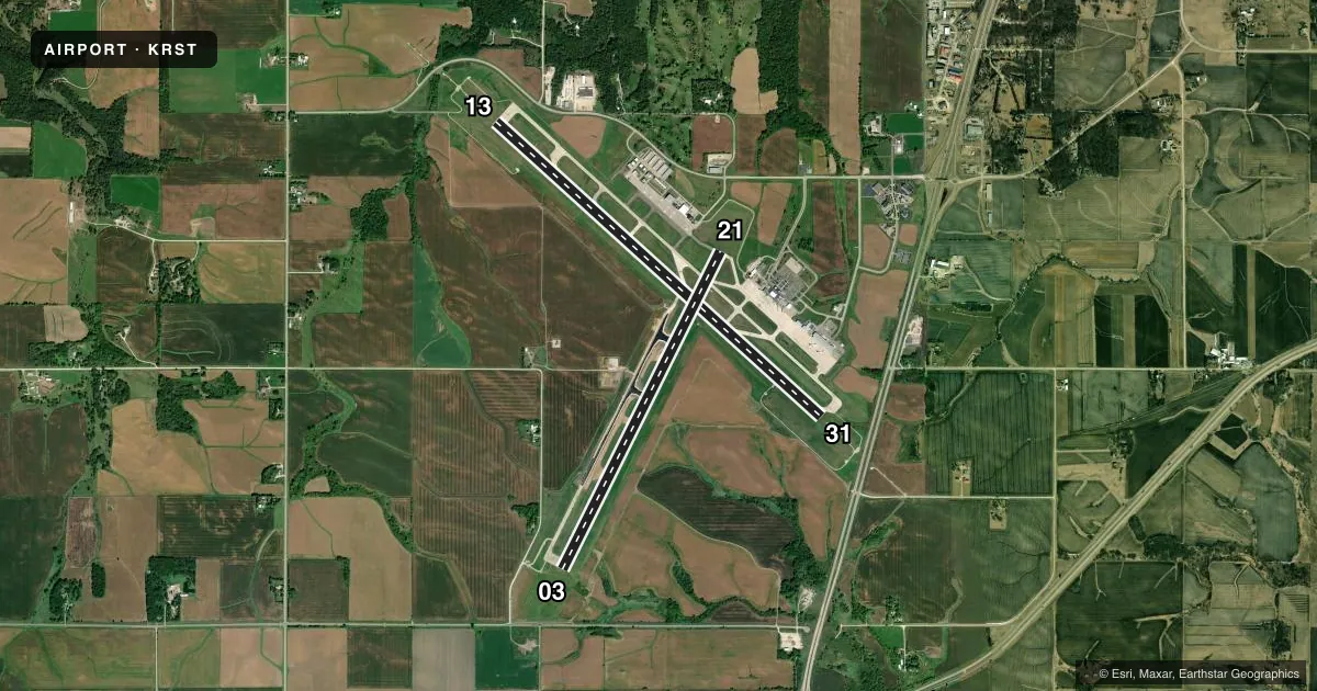
Runways & pattern
Full pagePattern entry · RWY 31
LEFT TRAFFIC| Runway | Heading (°M) | Length | Surface | Traffic |
|---|---|---|---|---|
| 13/31Favored | 131° / 311° | 9,034 ft | CONC | Standard L |
| 03/21 | 25° / 205° | 7,301 ft | ASPH-CONC | Standard L |
Runway end performance
| End | TORA | TODA | ASDA | LDA | VGSI | Approach lights | Obstruction |
|---|---|---|---|---|---|---|---|
| 13 | 9,033' | 9,033' | 9,033' | 9,033' | PAPI 4-box left(3°) | MALSR | — |
| 31 | 9,033' | 9,033' | 9,033' | 9,033' | PAPI 4-box left(3°) | ALSF2 | — |
| 03 | 7,300' | 7,300' | 7,300' | 7,300' | VASI 4-box left(3°) | — | — |
| 21 | 7,300' | 7,300' | 7,300' | 7,300' | PAPI 4-box left(3.05°) | — | — |
Declared distances in feet. TORA = takeoff run available, TODA = takeoff distance, ASDA = accelerate-stop, LDA = landing distance.
Airport sketch
Runways drawn to scale from FAA survey coordinates, rendered over satellite imagery. Not for navigation.
Approaches & charts
ILS · 2
Services on the field
Fuel grades, oxygen, maintenance, ramp storage and lighting — as declared to the FAA by the airport operator.
Fuel & services
- Fuel
- 100LLA
- Oxygen (bottled)
- HIGH/LOW
- Oxygen (bulk)
- Not available
- Airframe repair
- Major
- Power plant repair
- Major
- Other services
- CHTR,INSTR,RNTL
Ramp & ground
- Transient storage
- Hangar
- Landing fee
- No fee published
- Customs
- Not available
- Lighting schedule
- SEE RMK
- Beacon schedule
- SS-SR
- Beacon
- White / Green (civil land)(WG)
- Wind indicator
- Lighted
- Segmented circle
- No
Fuel & FBOs
Cheapest 100LL and Jet A on the field and nearby. Always confirm with the FBO before taxi.
Airport notes
Surface conditions, obstructions, local procedures, lighting outages and other notes published with each FAA cycle.
General notes
- WHEN ATCT CLSD SNOW REMOVAL EQPT PSNL MNT CTAF.
- WATERFOWL ON & INVOF ARPT.
- US CUST AVBL MON-FRI 0830-1700; PN AFT HRS & WKENDS CALL 507-285-5278.
- FOR CD WHEN ATCT IS CLSD CTC FSS VIA RCO, IF UNA CTC MINNEAPOLIS ARTCC AT 651-463-5588.
Lighting notes
- WHEN ATCT CLSD ACTVT OR INCR INTST MALSR RWY 13; HIRL RWY 13/31; MIRL RWY 03/21 - CTAF. HIRL RWY 13/31 PRESET LOW INTST. PAPI RWY 13, 21, & 31; VASI RWY 03 - OPR CONSLY.
Fuel notes
- 100LLAVBL 24 HRS WITH CREDIT CARD.
Runway surface & condition
- 03/21PCR VALUE: 890/F/D/X/T
- 13/31PCR VALUE: 890/R/D/W/T
Approach & departure obstructions
- 13RVR UNAVBL WHEN ATCT CLSD.
- 31RVR UNAVBL WHEN ATCT CLSD.
Other notes
- 24 HR PPR FOR UNSKED ACR OPS GTR THAN 9 PAX SEATS BTN 2300-0500 CALL 507-254-1161.
- 03/21RWY 03 END 2075 FT CONC, MID 3777 FT ASPHALT, RWY 21 END 1449 FT CONC.
VFR map & nearby airports
VFR sectional. Tap any ICAO chip to open that airport.
Key facts · KRST
Answer card- ICAO
- KRST
- Name
- ROCHESTER INTL
- Location
- ROCHESTER, MINNESOTA
- Elevation
- 1,317.4 ft MSL
- Traffic pattern altitude
- 2,317.4 ft MSL (1,000 AGL)
- Control tower
- Towered · 0500-2300
- Total runways
- 2
- Longest runway
- 13/31 · 9,034 ft
- Published ILS approaches
- 2
- Published frequencies
- 10
- Magnetic variation
- 1°
- Current flight rules
- VFR
- Current wind
- 290° at 15 kt
- Favored runway now
- RWY 31
Rochester Intl is in Rochester, Minnesota. The field elevation is 1,317.4 ft MSL. It has two runways. The longest is 9,034 ft on runway 13/31. The other runway is 03/21 at 7,301 ft. The airport has a control tower. Tower hours are 0500 to 2300.
ILS is available on runway ends 13 and 31. Pattern altitude is not published in the facts. Use the standard 1,000 ft AGL for light piston traffic unless ATC or the current FAA Chart Supplement says otherwise. Signature Aviation is on the field. It carries 100LL and Jet A. Call (507) 282-1717 for current service details.
A few published remarks matter here. 100LL is available 24 hours with credit card payment. Waterfowl are present on and near the airport. When the tower is closed, snow removal personnel monitor CTAF. The airport also publishes after-hours access rules for larger unscheduled aircraft between 2300 and 0500. Rochester is a busy controlled field, so plan for towered operations, taxi instructions and current approach lighting use. Check the current FAA Chart Supplement for any noise or curfew restrictions before flying into the field.