METAR & TAF KLBL
Current METAR
Observed 16:56Z
KLBL 271656Z AUTO 20016KT 10SM CLR 38/16 A2993 RMK AO2 SLP089 T03830161
- Wind
- 200° @ 16 kt
- Visibility
- 10 SM
- Temp / Dew
- 38°C / 16°C
- Altimeter
- 29.93 inHg
- Clouds
- CLR
- Density alt
- 6,325 ft
- Ceiling
- Unlimited
- Rules
- VFR
Airport info & contacts
Manager on record, flight service, ARTCC, attendance schedule and pattern altitude — published by the FAA and refreshed every 28 days.
Location
- From city
- 2 NM W
- VFR sectional
- WICHITA
- ARTCC
- ZKC · KANSAS CITY
- NOTAM facility
- LBL (NOTAM-D)
Airport manager
- Name
- MR. BRIAN FORNWALT
- Phone
- (620) 626-0188
- Address
- PO BOX 2199, LIBERAL KS 67905-2199
Flight service · Hours
- FSS ICT
- WICHITA1-800-WX-BRIEF
- Attendance
- MON-FRI · 0600-2000
- SAT-SUN · 0700-2000
Frequencies
Tap any row to copy the frequency to your clipboard.
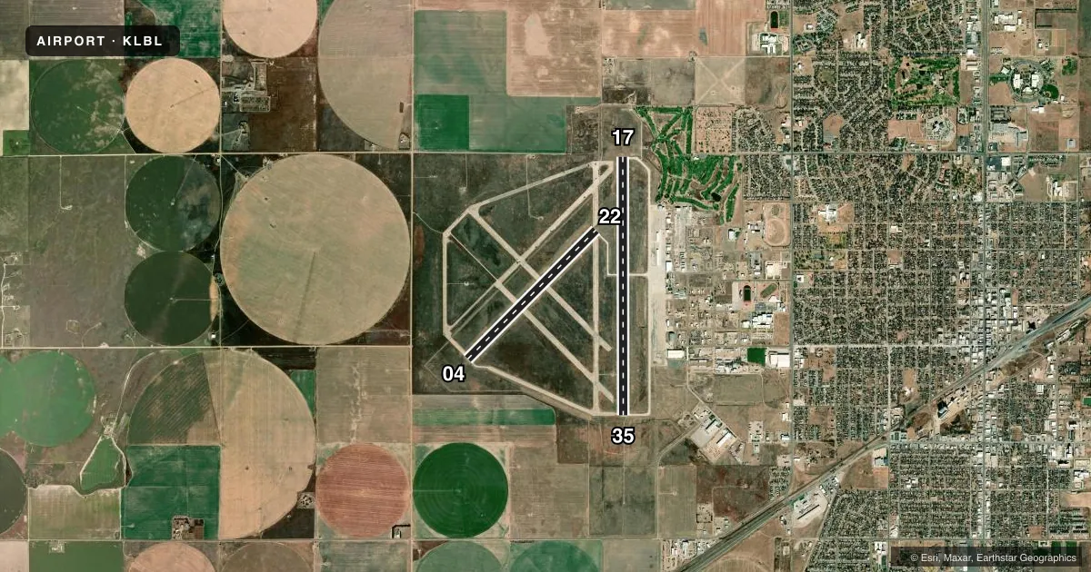
Runways & pattern
Full pagePattern entry · RWY 17
LEFT TRAFFIC| Runway | Heading (°M) | Length | Surface | Traffic |
|---|---|---|---|---|
| 17/35Favored | 174° / 354° | 7,105 ft | CONC | Standard L |
| 04/22 | 39° / 219° | 5,000 ft | CONC | Standard L |
Runway end performance
| End | TORA | TODA | ASDA | LDA | VGSI | Approach lights | Obstruction |
|---|---|---|---|---|---|---|---|
| 17 | 7,105' | 7,105' | 7,105' | 7,105' | VASI 4-box left(3°) | — | — |
| 35 | 7,105' | 7,105' | 7,105' | 7,105' | VASI 4-box left(3°) | MALSR | — |
| 04 | 5,000' | 5,000' | 5,000' | 5,000' | PAPI 4-box left(3°) | — | — |
| 22 | 5,000' | 5,000' | 5,000' | 5,000' | PAPI 4-box left(3°) | — | — |
Declared distances in feet. TORA = takeoff run available, TODA = takeoff distance, ASDA = accelerate-stop, LDA = landing distance.
Airport sketch
Runways drawn to scale from FAA survey coordinates, rendered over satellite imagery. Not for navigation.
Approaches & charts
ILS · 1
Services on the field
Fuel grades, oxygen, maintenance, ramp storage and lighting — as declared to the FAA by the airport operator.
Fuel & services
- Fuel
- 100LLA
- Oxygen (bottled)
- Not available
- Oxygen (bulk)
- Low pressure
- Airframe repair
- Major
- Power plant repair
- Major
- Other services
- AGRI,CHTR,INSTR,RNTL,SALES
Ramp & ground
- Transient storage
- Tie-down
- Hangar
- Landing fee
- No fee published
- Customs
- Not available
- Lighting schedule
- SEE RMK
- Beacon schedule
- SS-SR
- Beacon
- White / Green (civil land)(WG)
- Wind indicator
- Lighted
- Segmented circle
- Yes
Fuel & FBOs
Cheapest 100LL and Jet A on the field and nearby. Always confirm with the FBO before taxi.
Airport notes
Surface conditions, obstructions, local procedures, lighting outages and other notes published with each FAA cycle.
General notes
- FOR CD IF UNA TO CTC ON FSS FREQ, CTC KANSAS CITY ARTCC AT 913-254-8508.
Lighting notes
- ACTVT MIRL RY 04/22 & HIRL RY 17/35; MALSR RY 35; VASI RYS 17 & 35; & PAPI RYS 04 & 22; REIL RYS 04, 17 & 22 - CTAF.
Runway surface & condition
- 04/22PCR VALUE: 110/R/D/W/T
- 17/35PCR VALUE: 340/R/C/W/T
Other notes
- 24 HR PPR FOR UNSKED ACR OPNS WITH MORE THAN 30 PSGR SEATS CALL AMGR (620) 626-2207 OR (620) 626-0150. ACR OPNS OVER 9 PSGR SEATS NOT AUTH OVER 15 MINUTES BEFORE OR AFTER SKED ARR OR DEP TIMES EXCP WITH PRIOR COORD WITH AMGR OR FIRE DEPT. ARFF INDEX B IS PROVIDED.
VFR map & nearby airports
VFR sectional. Tap any ICAO chip to open that airport.
Key facts · KLBL
Answer card- ICAO
- KLBL
- Name
- LIBERAL MID-AMERICA RGNL
- Location
- LIBERAL, KANSAS
- Elevation
- 2,885.4 ft MSL
- Traffic pattern altitude
- 3,885.4 ft MSL (1,000 AGL)
- Control tower
- Non-towered (use CTAF)
- Total runways
- 2
- Longest runway
- 17/35 · 7,105 ft
- Published ILS approaches
- 1
- Published frequencies
- 2
- Magnetic variation
- 6°
- Current flight rules
- VFR
- Current wind
- 200° at 16 kt
- Favored runway now
- RWY 17
Liberal Mid-America Rgnl sits in Liberal, Kansas. Field elevation is 2,885.4 ft MSL. The airport has two concrete runways. The longest is 7,105 ft on 17/35. There is no control tower, so use CTAF 122.8 for self-announce traffic. Pattern altitude is not published. Use 3,885 ft MSL for light piston traffic unless the current Chart Supplement says otherwise.
Runway 35 has the published ILS. Runway 17/35 also has high intensity runway lights. Runway 04/22 has medium intensity runway lights. PAPI is published on 04 and 22. VASI is published on 17 and 35. REILs are published on 04, 17 and 22. That gives you a solid night and IFR setup for a regional field in southwest Kansas.
Lyddon Aero Center is on the field. It carries 100LL, Jet A and Jet A Prist. For any ramp or fuel detail before arrival, call them directly at (620) 624-1646. The published remarks also note prior permission is required for some unscheduled large aircraft operations. There are timing limits for aircraft over 9 passenger seats near scheduled arrivals and departures. If you are bringing a larger aircraft, coordinate early with the airport manager or fire department. Clearance delivery fallback is Kansas City Center if you cannot reach Flight Service.