METAR & TAF KGFK
Current METAR
Observed 22:53Z
KGFK 272253Z 01009KT 9SM FEW034 SCT060 OVC110 29/21 A2981 RMK AO2 SLP091 FU ALOFT T02940206 $
- Wind
- 010° @ 9 kt
- Visibility
- 9 SM
- Temp / Dew
- 29°C / 21°C
- Altimeter
- 29.81 inHg
- Clouds
- OVC
- Density alt
- 2,864 ft
- Ceiling
- 11,000 ft AGL
- Rules
- VFR
Airport info & contacts
Manager on record, flight service, ARTCC, attendance schedule and pattern altitude — published by the FAA and refreshed every 28 days.
Location
- From city
- 5 NM NW
- VFR sectional
- TWIN CITIES
- Pattern altitude
- 800 ft AGL · 1,645 ft MSL
- ARTCC
- ZMP · MINNEAPOLIS
- NOTAM facility
- GFK (NOTAM-D)
Airport manager
- Name
- RYAN RIESINGER
- Phone
- 701-795-6981
- Address
- 2301 AIRPORT DR, GRAND FORKS ND 58203
Flight service · Hours
- FSS GFK
- GRAND FORKS1-800-WX-BRIEF
- Attendance
- ALL
Frequencies
Tap any row to copy the frequency to your clipboard.
Runways & pattern
Full pagePattern entry · RWY 35L
LEFT TRAFFIC| Runway | Heading (°M) | Length | Surface | Traffic |
|---|---|---|---|---|
| 17R/35LFavored | 174° / 354° | 7,351 ft | ASPH | 17R R |
| 09L/27R | 84° / 264° | 6,701 ft | CONC | 27R R |
| 17L/35R | 174° / 354° | 3,901 ft | CONC | 35R R |
| 09R/27L | 84° / 264° | 3,300 ft | CONC | 09R R |
Runway end performance
| End | TORA | TODA | ASDA | LDA | VGSI | Approach lights | Obstruction |
|---|---|---|---|---|---|---|---|
| 17R | 7,351' | 7,351' | 7,351' | 7,351' | PAPI 4-box left(3°) | — | — |
| 35L | 7,351' | 7,351' | 7,351' | 7,351' | PAPI 4-box left(2.76°) | MALSR | — |
| 09L | 6,701' | 6,701' | 6,701' | 6,701' | PAPI 4-box left(3°) | — | — |
| 27R | 6,701' | 6,701' | 6,701' | 6,701' | PAPI 4-box left(3°) | — | — |
| 17L | 3,901' | 3,901' | 3,901' | 3,901' | PAPI 4-box left(3°) | — | — |
| 35R | 3,901' | 3,901' | 3,901' | 3,901' | PAPI 4-box left(3°) | — | — |
| 09R | 3,300' | 3,300' | 3,300' | 3,300' | PAPI 2-box left(3°) | — | — |
| 27L | 3,300' | 3,300' | 3,300' | 3,300' | PAPI 2-box left(3°) | — | — |
Declared distances in feet. TORA = takeoff run available, TODA = takeoff distance, ASDA = accelerate-stop, LDA = landing distance.
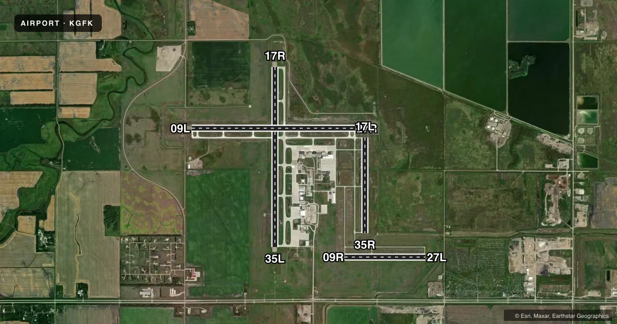
Airport sketch
Runways drawn to scale from FAA survey coordinates, rendered over satellite imagery. Not for navigation.
Approaches & charts
ILS · 1
Services on the field
Fuel grades, oxygen, maintenance, ramp storage and lighting — as declared to the FAA by the airport operator.
Fuel & services
- Fuel
- 100LLA
- Oxygen (bottled)
- High pressure
- Airframe repair
- Major
- Power plant repair
- Major
- Other services
- CARGO,CHTR,INSTR,RNTL,SALES,SURV
Ramp & ground
- Transient storage
- Tie-down
- Landing fee
- No fee published
- Customs
- Available
- Lighting schedule
- SEE RMK
- Beacon schedule
- SS-SR
- Beacon
- White / Green (civil land)(WG)
- Wind indicator
- Lighted
- Segmented circle
- No
Fuel & FBOs
Cheapest 100LL and Jet A on the field and nearby. Always confirm with the FBO before taxi.
Airport notes
Surface conditions, obstructions, local procedures, lighting outages and other notes published with each FAA cycle.
General notes
- HVY STUDENT TRNG ACTVTY WI 15 MI OF ARPT.
- BIRDS ON & INVOF ARPT.
- LGTD ENTRANCE RD 1600' EAST OF RY 17R/35L.
- CUSTOMS AVBL 24/7/365. YOU MUST SPEAK WITH AN OFFICER BEFORE ARRIVAL (USE PHONE OPTIONS) 701-772-3301 OR 701-772-6433.
- PAEW 2330-0600 LOCAL
- HVY STUDENT HELICOPTER TRAINING AT ARPT BTN PARALLEL TWYS.-
- TWY G, TWY N, & TWY U CLSD TO FIXED WING ACFT 12,500 LBS & OVER.
- WESTERN MOST 100 FT OF TWY C1 IS AN EXTENSION OF THE BRAVO APRON & NOT VSBL FR THE TWR.
- TWY C SOUTH OF TWY B, TWY E, TWY S NOT AVBL FOR SKED ACR OPNS WITH MORE THAN 9 PSGR SEATS OR UNSKED ACR OPNS WITH AT LEAST 31 PSGR SEATS.
- FOR CD IF UNA TO CTC ON FSS FREQ, CTC MINNEAPOLIS ARTCC AT 651-463-5588.
- RWY 17R SEGMENTED CIRCLE U/S.
Lighting notes
- WHEN TWR CLSD ACTVT MALSR RWY 35L; REIL RWY 09L, 17R, & 27R; MIRL RWY 09L/27R; MIRL 9R/27L; MIRL RWY 17L/35R; HIRL RWY 17R/35L - CTAF. PAPI RWY 09L, 09R, 17L, 17R, 27L, 27R, 35L, 35R OPR CONSLY.
Runway surface & condition
- 09L/27RPCR VALUE: 630/R/C/W/T
- 09R/27LPCR VALUE: 150/R/C/W/T
- 17L/35RPCR VALUE: 150/R/C/W/T
- 17R/35LPCR VALUE: 1000/R/C/W/T
- 09R/27LRWY 09R/27L NOT AVBL FOR PART 121/PART 380 OPS WITH SKED PAX CARRYING OPS MORE THAN 9 PAX SEATS AND NON-SKED PAX CARRYING OPS MORE THAN 30 PAX SEATS.
- 17L/35RRWY 17L/35R NOT AVBL FOR PART 121/PART 380 OPS WITH SKED PAX CARRYING OPS MORE THAN 9 PAX SEATS AND NON-SKED PAX CARRYING OPS MORE THAN 30 PAX SEATS.
Other notes
- ARFF INDEX C SVCS AVBL WITH 24 HR PPR. CALL AMGR AT 701-795-6984.
- ASST_MGRARPT OPS & FAC MGR.
VFR map & nearby airports
VFR sectional. Tap any ICAO chip to open that airport.
Key facts · KGFK
Answer card- ICAO
- KGFK
- Name
- GRAND FORKS INTL
- Location
- GRAND FORKS, NORTH DAKOTA
- Elevation
- 845.2 ft MSL
- Traffic pattern altitude
- 1,645.2 ft MSL (800 AGL)
- Control tower
- Towered · 0600-2330
- Total runways
- 4
- Longest runway
- 17R/35L · 7,351 ft
- Published ILS approaches
- 1
- Published frequencies
- 11
- Magnetic variation
- 6°
- Current flight rules
- VFR
- Current wind
- 010° at 9 kt
- Favored runway now
- RWY 35L
Grand Forks Intl is in Grand Forks, North Dakota. The field elevation is 845.1 ft MSL. It has four runways. The longest is 7,351 ft. Tower service runs from 0600 to 2330. The airport has one ILS approach to runway 35L. Pattern altitude is 800 ft AGL, which is 1,645.1 ft MSL.
Avflight Grand Forks is on the field. It carries 100LL, Jet A and Jet A Prist. The airport sits in a busy training environment. Heavy student helicopter training occurs between the parallel taxiways. Taxiways G, N and U are closed to fixed-wing aircraft at 12,500 lb and above. That matters for taxi planning.
Runway 17R/35L is the longest runway. Runway 17L/35R is not available for Part 121 or Part 380 passenger operations above the published seat limits. The same restriction also applies to runway 09R/27L. When the tower is closed, lighting is activated on CTAF. The published remarks also note a lighted entrance road east of runway 17R/35L. The segmented circle for runway 17R is unserviceable. Check the current FAA Chart Supplement for any noise or curfew restrictions before flying into the field.