METAR & TAF KCMI
Current METAR
Observed 22:19Z
KCMI 272219Z 12005KT 9SM VCTS -RA SCT038 SCT050 OVC100 28/27 A2979 RMK AO2 LTG DSNT ALQDS RAE04B14 TSE01 P0001 T02830272
- Wind
- 120° @ 5 kt
- Visibility
- 9 SM
- Temp / Dew
- 28°C / 27°C
- Altimeter
- 29.79 inHg
- Clouds
- OVC
- Density alt
- 2,657 ft
- Ceiling
- 10,000 ft AGL
- Rules
- VFR
Airport info & contacts
Manager on record, flight service, ARTCC, attendance schedule and pattern altitude — published by the FAA and refreshed every 28 days.
Location
- From city
- 5 NM SW
- VFR sectional
- CHICAGO
- Pattern altitude
- 750 ft AGL · 1,505 ft MSL
- ARTCC
- ZAU · CHICAGO
- NOTAM facility
- CMI (NOTAM-D)
Airport manager
- Name
- TIMOTHY BANNON
- Phone
- 217-244-8604
- Address
- 11 AIRPORT RD, SAVOY IL 61874
Flight service · Hours
- FSS STL
- SAINT LOUIS1-800-WX-BRIEF
- Attendance
- ALL
Frequencies
Tap any row to copy the frequency to your clipboard.
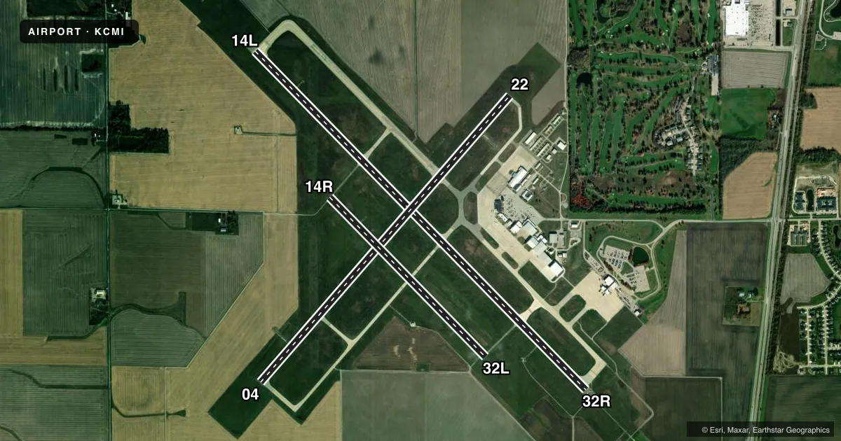
Runways & pattern
Full pagePattern entry · RWY 14L
LEFT TRAFFIC| Runway | Heading (°M) | Length | Surface | Traffic |
|---|---|---|---|---|
| 14L/32RFavored | 133° / 313° | 8,101 ft | ASPH-CONC | Standard L |
| 04/22 | 38° / 218° | 6,502 ft | ASPH | Standard L |
| 14R/32L | 133° / 313° | 3,816 ft | ASPH | Standard L |
Runway end performance
| End | TORA | TODA | ASDA | LDA | VGSI | Approach lights | Obstruction |
|---|---|---|---|---|---|---|---|
| 14L | 8,101' | 8,101' | 8,101' | 8,101' | PAPI 4-box left(3°) | — | — |
| 32R | 8,101' | 8,101' | 8,101' | 8,101' | PAPI 4-box left(3°) | MALSR | — |
| 04 | 6,502' | 6,502' | 6,502' | 6,502' | PAPI 4-box left(3°) | — | — |
| 22 | 6,502' | 6,502' | 6,502' | 6,502' | PAPI 4-box left(3°) | — | 53', tree, 1687' from thr, 279' R of cntrln, slope 28 |
| 14R | 3,816' | 3,816' | 3,816' | 3,816' | PAPI 4-box left(3°) | — | — |
| 32L | 3,816' | 3,816' | 3,816' | 3,816' | PAPI 4-box left(3°) | — | — |
Declared distances in feet. TORA = takeoff run available, TODA = takeoff distance, ASDA = accelerate-stop, LDA = landing distance.
Airport sketch
Runways drawn to scale from FAA survey coordinates, rendered over satellite imagery. Not for navigation.
Approaches & charts
ILS · 1
Services on the field
Fuel grades, oxygen, maintenance, ramp storage and lighting — as declared to the FAA by the airport operator.
Fuel & services
- Fuel
- 100LLA1+
- Oxygen (bottled)
- Not available
- Oxygen (bulk)
- High pressure
- Airframe repair
- Major
- Power plant repair
- Major
- Other services
- AVNCS,CHTR,INSTR,SURV
Ramp & ground
- Transient storage
- Tie-down
- Landing fee
- No fee published
- Customs
- Not available
- Lighting schedule
- SEE RMK
- Beacon schedule
- SS-SR
- Beacon
- White / Green (civil land)(WG)
- Wind indicator
- Lighted
- Segmented circle
- No
Fuel & FBOs
Cheapest 100LL and Jet A on the field and nearby. Always confirm with the FBO before taxi.
Airport notes
Surface conditions, obstructions, local procedures, lighting outages and other notes published with each FAA cycle.
General notes
- TSNT PRKG ON SE GA APN.
- BIRDS ON & INVOF ARPT.
- TWY E & D SW OF RWY 14L/32R CLSD TO ACFT ABV 11800 LB.
- TWY A2 & A3 ADJ TO ACR APN NOT VSB FM ATCT.
- RWY 22 & 32R ENDS NOT VSB FM EACH OTR.
- FOR CD IF UNA TO CTC ON FSS FREQ, CTC CHICAGO ARTCC AT 630-906-8921.
- OPS HR H24; ATNDD CONSLY.
Lighting notes
- WHEN ATCT CLSD ACTVT MALSR RWY 32R; PAPI RWY 14L/32R; MIRL RWY 04/22; HIRL RWY 14L/32R - CTAF. HIRL RWY 14L/32R PRESET TO LOW INTST; INCR INTST - CTAF.
Runway surface & condition
- 04/22PCR VALUE: 600/F/D/X/T
- 14L/32RPCR VALUE: 900/R/D/W/T
- 14R/32LPCR VALUE: 140/F/D/X/T
- 14R/32LRWY 14R/32L NOT AVBL FOR PART 121/PART 380 OPS WITH SKED PAX CARRYING OPS MORE THAN 9 PAX SEATS AND NON-SKED PAX CARRYING OPS MORE THAN 30 PAX SEATS. CLSD 2300-0600 & TO ACFT ABV 12500 LB.
Approach & departure obstructions
- 32RRWY 32R CALM WIND RWY WHEN ATCT CLSD.
Other notes
- 2 HR PPR - 217-729-7607.
VFR map & nearby airports
VFR sectional. Tap any ICAO chip to open that airport.
Key facts · KCMI
Answer card- ICAO
- KCMI
- Name
- UNIVERSITY OF ILLINOIS/WILLARD
- Location
- CHAMPAIGN/URBANA, ILLINOIS
- Elevation
- 754.9 ft MSL
- Traffic pattern altitude
- 1,504.9 ft MSL (750 AGL)
- Control tower
- Towered · 0600-2300
- Total runways
- 3
- Longest runway
- 14L/32R · 8,101 ft
- Published ILS approaches
- 1
- Published frequencies
- 19
- Magnetic variation
- 3°
- Current flight rules
- VFR
- Current wind
- 120° at 5 kt
- Favored runway now
- RWY 14L
University of Illinois/Willard Airport sits in Champaign/Urbana, Illinois. Field elevation is 754.9 ft MSL. KCMI has three asphalt runways. The longest is 14L/32R at 8,101 ft. The tower is open from 0600 to 2300. One ILS approach is published for runway 32R. Pattern altitude is 750 ft AGL, which is 1,504.9 ft MSL.
Flightstar is on the field. It carries 100LL, Jet A and Jet A Prist. Call the FBO at (217) 351-7700 for current services. Transient parking is on the southeast general aviation apron. Two-hour prior permission is required by calling 217-729-7607.
A few operational notes matter here. Runway 32R is the calm wind runway when the tower is closed. The runway lights and approach lighting for 32R can be activated on CTAF after hours. Runway 14R/32L is closed from 2300 to 0600. It is also closed to aircraft above 12,500 pounds. Birds are reported on and near the airport. Taxiways A2 and A3 beside the apron are not visible from the tower. If you are planning a first arrival, verify current procedures in the FAA Chart Supplement. Be ready for Class C operations on the Champaign side of the field.