METAR & TAF C80
C80 does not publish a METAR.
Showing the nearest reporting station: KPRB (PASO ROBLES MUNI) · 33.5 NM away. Conditions at C80 may differ.
METAR · KPRB
Observed 14:53Z
KPRB 111453Z AUTO 00000KT 10SM CLR 19/07 A2988 RMK AO2 SLP110 T01890072 51013
- Wind
- 000° @ 0 kt
- Visibility
- 10 SM
- Temp / Dew
- 19°C / 7°C
- Altimeter
- 29.88 inHg
- Clouds
- CLR
- Density alt
- 1,304 ft
- Ceiling
- Unlimited
- Rules
- VFR
Airport info & contacts
Manager on record, flight service, ARTCC, attendance schedule and pattern altitude — published by the FAA and refreshed every 28 days.
Location
- From city
- 3 NM E
- VFR sectional
- SAN FRANCISCO
- ARTCC
- ZOA · OAKLAND
- NOTAM facility
- RIU (NOTAM-D)
Airport manager
- Name
- MERCEDES GARCIA
- Phone
- 559-246-6243
- Address
- THE CITY OF COALINGA, 155 W DURIAN, COALINGA CA 93210-1911
Flight service · Hours
- FSS RIU
- RANCHO MURIETA1-800-WX-BRIEF
- Attendance
- IREG
Frequencies
Tap any row to copy the frequency to your clipboard.
Runways & pattern
Full pagePattern entry · RWY 12
LEFT TRAFFIC| Runway | Heading (°M) | Length | Surface | Traffic |
|---|---|---|---|---|
| 12/30 | 116° / 296° | 5,000 ft | ASPH | 30 R |
| 01/19 | 357° / 177° | 2,471 ft | ASPH-GRVL | 19 R |
Runway end performance
| End | TORA | TODA | ASDA | LDA | VGSI | Approach lights | Obstruction |
|---|---|---|---|---|---|---|---|
| 12 | — | — | — | — | PAPI 2-box left(3°) | — | — |
| 30 | — | — | — | — | PAPI 2-box left(3°) | — | — |
Declared distances in feet. TORA = takeoff run available, TODA = takeoff distance, ASDA = accelerate-stop, LDA = landing distance.
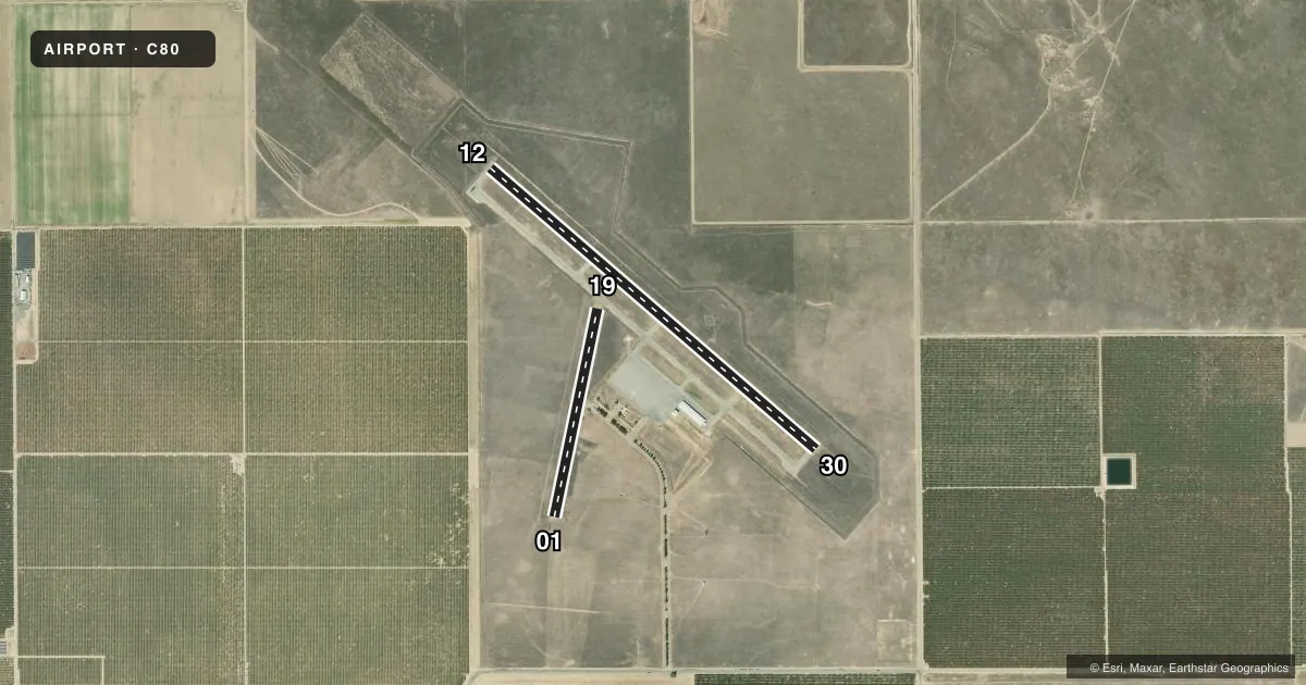
Airport sketch
Runways drawn to scale from FAA survey coordinates, rendered over satellite imagery. Not for navigation.
Approaches & charts
Services on the field
Fuel grades, oxygen, maintenance, ramp storage and lighting — as declared to the FAA by the airport operator.
Fuel & services
- Fuel
- Not available
Ramp & ground
- Transient storage
- Tie-down
- Landing fee
- No fee published
- Lighting schedule
- SEE RMK
- Beacon schedule
- SEE RMK
- Beacon
- White / Green (civil land)(WG)
- Wind indicator
- Lighted
- Segmented circle
- Yes
Fuel & FBOs
Cheapest 100LL and Jet A on the field and nearby. Always confirm with the FBO before taxi.
Airport notes
Surface conditions, obstructions, local procedures, lighting outages and other notes published with each FAA cycle.
General notes
- FOR CD CTC OAKLAND ARTCC AT 510-745-3380.
- AWOS OTS.
Lighting notes
- DUSK-DAWN.
- REIL RWYS 12 & 30; MIRL RWY 12/30; PERIMETER LGTS H1 ON DUSK-0000; AFTER 0000 ACTVT - CTAF. PAPI RWYS 12 & 30 OPR CONSLY.
Runway surface & condition
- 01/19RWY CLSD.
Approach & departure obstructions
- 30RWY 30 VGSI OTS.
Other notes
- MANAGERMGARCIA@COALINGA.COM
- 01/19RWY SFC FAILED WITH POTHOLES AND BRUSH.
VFR map & nearby airports
VFR sectional. Tap any ICAO chip to open that airport.
Key facts · C80
Answer card- ICAO
- C80
- Name
- NEW COALINGA MUNI
- Location
- COALINGA, CALIFORNIA
- Elevation
- 624.8 ft MSL
- Traffic pattern altitude
- 1,624.8 ft MSL (1,000 AGL)
- Control tower
- Non-towered (use CTAF)
- Total runways
- 2
- Longest runway
- 12/30 · 5,000 ft
- Published ILS approaches
- 0
- Published frequencies
- 2
- Magnetic variation
- 15°
- Current flight rules
- VFR
- Current wind
- 000° at 0 kt
- Favored runway now
- –
New Coalinga Muni is in Coalinga, California. The field elevation is 624.8 ft MSL. It has two asphalt runways, but the usable runway for most traffic is 12/30 at 5,000 ft. Runway 01/19 is closed. This is an untowered field, so plan to self-announce on CTAF 122.7. UNICOM is also 122.7.
No ILS approaches are published here. AWOS is out of service, so get the latest weather before departure and do not count on an automated report on arrival. The pattern altitude is not published. Use the standard 1,000 ft AGL for light piston aircraft unless the current Chart Supplement says otherwise. That puts the pattern at about 1,625 ft MSL based on the field elevation.
The on-field FBO is New Coalinga Municipal Airport. It carries AVGAS 100LL. For clearance delivery, contact Oakland ARTCC at 510-745-3380. The published remarks also note that the beacon runs from dusk to dawn. Runway 12/30 has medium intensity lights, runway end identifier lights and PAPI. Runway 30 has a visual glide slope indicator that is out of service. The closed 01/19 surface has potholes and brush, so do not plan to use it. If you are coming in at night, verify lighting status before you launch.