METAR & TAF KTPA
Current METAR
Observed 08:53Z
KTPA 280853Z COR 28007KT 10SM SCT017 BKN022 BKN250 29/26 A2985 RMK AO2 SLP106 T02890261 55008 $
- Wind
- 280° @ 7 kt
- Visibility
- 10 SM
- Temp / Dew
- 29°C / 26°C
- Altimeter
- 29.85 inHg
- Clouds
- BKN
- Density alt
- 1,800 ft
- Ceiling
- 2,200 ft AGL
- Rules
- MVFR
Airport info & contacts
Manager on record, flight service, ARTCC, attendance schedule and pattern altitude — published by the FAA and refreshed every 28 days.
Location
- From city
- 6 NM W
- VFR sectional
- MIAMI
- ARTCC
- ZMA · MIAMI
- NOTAM facility
- TPA (NOTAM-D)
Airport manager
- Name
- JOHN TILIACOS
- Phone
- 813-870-8700
- Address
- PO BOX 22287, TAMPA FL 33622
Flight service · Hours
- FSS PIE
- SAINT PETERSBURG1-800-WX-BRIEF
- Attendance
- ALL
Frequencies
Tap any row to copy the frequency to your clipboard.
Runways & pattern
Full pagePattern entry · RWY 28
LEFT TRAFFIC| Runway | Heading (°M) | Length | Surface | Traffic |
|---|---|---|---|---|
| 01L/19R | 357° / 177° | 11,002 ft | CONC | Standard L |
| 01R/19L | 357° / 177° | 8,300 ft | ASPH-CONC | Standard L |
| 10/28Favored | 87° / 267° | 6,999 ft | ASPH-CONC | Standard L |
Runway end performance
| End | TORA | TODA | ASDA | LDA | VGSI | Approach lights | Obstruction |
|---|---|---|---|---|---|---|---|
| 01L | 11,002' | 11,002' | 10,800' | 10,800' | PAPI 4-box left(3°) | ALSF2 | — |
| 19R | 11,002' | 11,002' | 11,002' | 11,002' | PAPI 4-box left(3°) | MALSR | 15', road, 955' from thr, 500' R of cntrln, slope 50 |
| 01R | 8,300' | 8,300' | 8,300' | 8,300' | PAPI 4-box left(3°) | — | — |
| 19L | 8,300' | 8,300' | 8,300' | 8,300' | PAPI 4-box left(3°) | ALSF2 | — |
| 10 | 6,999' | 6,999' | 6,999' | 6,501' | PAPI 4-box left(3°) | — | 18', rr, 755' from thr, 300' R of cntrln, slope 30 |
| 28 | 6,999' | 6,999' | 6,501' | 6,501' | PAPI 4-box left(3°) | — | 41', trees, 1660' from thr, 190' R of cntrln, slope 35 |
Declared distances in feet. TORA = takeoff run available, TODA = takeoff distance, ASDA = accelerate-stop, LDA = landing distance.
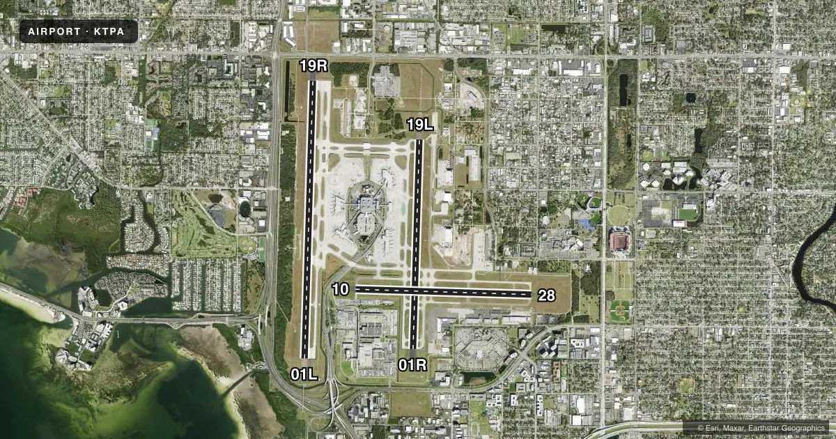
Airport sketch
Runways drawn to scale from FAA survey coordinates, rendered over satellite imagery. Not for navigation.
Approaches & charts
ILS · 4
Services on the field
Fuel grades, oxygen, maintenance, ramp storage and lighting — as declared to the FAA by the airport operator.
Fuel & services
- Fuel
- 100LLA
- Oxygen (bottled)
- HIGH/LOW
- Oxygen (bulk)
- HIGH/LOW
- Airframe repair
- Major
- Power plant repair
- Major
- Other services
- AVNCS,CARGO,CHTR
Ramp & ground
- Transient storage
- Tie-down
- Hangar
- Landing fee
- No fee published
- Customs
- Available
- Lighting schedule
- SS-SR
- Beacon schedule
- SS-SR
- Beacon
- White / Green (civil land)(WG)
- Wind indicator
- Lighted
- Segmented circle
- Yes
Fuel & FBOs
Cheapest 100LL and Jet A on the field and nearby. Always confirm with the FBO before taxi.
Airport notes
Surface conditions, obstructions, local procedures, lighting outages and other notes published with each FAA cycle.
General notes
- RWY 19L IS NOISE SENSITIVE TO TBJT DEPARTURES. RWY 01R IS NOISE SENSITIVE TO TBJT ARRIVALS. PUBLD NOISE ABATEMENT PROCS IN EFCT.
- ONLY ACFT WITH PRIOR PMSN MAY USE TRML APN; ALL OTRS USE GA APN.
- BIRD ACT ON AND INVOF ARPT.
- TXL F AND TXL R ARE NON-MOVEMENT AREAS. BOTH LCTNS ARE UNAVBL FOR GROUP IV ACFT WITH A WINGSPAN GTR THAN 117 FT WO PPR FROM ARPT OPS. TXL T PPR FROM ARPT OPS RQRD FOR ACFT WITH A WINGSPAN GTR THAN 90 FT.
- TAXILANE G WEST OF TWY B1 CLSD TO WINGSPAN GTR THAN 118 FT - PPR APT OPS.
- RSTRS TO ADG IV OR LGR: TWY E1.
- TXL K1 AND TXL K2 CLSD TO WINGSPANS GTR THAN 171 FT, TXL K1 AND TXL K2 CLSD WHILE WIDE BODY TXL K1W IS IN USE.
- TWY J BTN TWY J1 AND TWY J2; TWY N W OF TWY L; TWY E N OF TWY J; TXL Z 325 FT E OF TXL V; TXL V BTN TWY V2 AND TWY V3 ARE UNAVBL FOR GROUP V ACFT WITH A WINGSPAN GTR THAN 171 FT WO PPR FROM ARPT OPS.
- 24 HR ADVN NOTICE OR IMT REPORTING UPON LDG FOR ACFT EQUIPPED WITH WEATHER MODIFICATION OR GEOENGINEERING EQUIP. 813-870-8770 EXT. 3
- US CUST AVBL 7 DAYS A WEEK, 0600-2200 HOURS. PPR 24 HOURS FOR AFT HOURS; CTC CBP SUPVR AT 813-676-4590; CTC AIRPORT OPERATIONS AT 813-870-8770.
- N RON RSTD TO TUG IN/TUG OUT OPS FOR ADG III OR LGR
Runway surface & condition
- 01L/19RPCR VALUE: 700/R/A/W/T
- 01R/19LPCR VALUE: 630/R/A/W/T
- 10/28PCR VALUE: 870/R/A/W/T
- 10/28NOT NMLY AVBL TO OPNS OVER 75,000 LBS GWT.
Approach & departure obstructions
- 10RWY 10 PAPI UNUSBL 8 DEG LEFT AND RIGHT OF RCL.
- 10RWY 10 APCH SFC IS 50:1 TO MKD DSPLCD THR.
Other notes
- MANAGER813-870-8752
- 10/28RWY 10 FIRST 2600 FT CONC; RWY 28 FIRST 4400 FT ASPH.
VFR map & nearby airports
VFR sectional. Tap any ICAO chip to open that airport.
Key facts · KTPA
Answer card- ICAO
- KTPA
- Name
- TAMPA INTL
- Location
- TAMPA, FLORIDA
- Elevation
- 26.5 ft MSL
- Traffic pattern altitude
- 1,026.5 ft MSL (1,000 AGL)
- Control tower
- Towered · 24
- Total runways
- 3
- Longest runway
- 01L/19R · 11,002 ft
- Published ILS approaches
- 4
- Published frequencies
- 25
- Magnetic variation
- 5°
- Current flight rules
- MVFR
- Current wind
- 280° at 7 kt
- Favored runway now
- RWY 28
Tampa Intl sits in Tampa, Florida. Field elevation is 26.5 ft MSL. The airport has 3 runways. The longest is 11,002 ft on 01L/19R. The tower is open 24 hours. Four ILS approaches are published for 01L, 01R, 19L and 19R.
For pattern work, the published pattern altitude is not listed in the facts. Use the current FAA Chart Supplement before you fly. This is a busy Class B airport with published noise abatement procedures. Runway 19L is noise sensitive for turbojet departures. Runway 01R is noise sensitive for turbojet arrivals. First-time pilots should expect heavy airline traffic. Expect close ATC coordination. Expect a lot of ground movement.
Signature Aviation is on the field. Sheltair is on the field too. Both carry 100LL, Jet A and Jet A Prist. Terminal apron use needs prior permission. Other aircraft use the general aviation apron. There are also several wingspan and taxiway restrictions that matter for larger aircraft. Check the current FAA Chart Supplement and coordinate with airport operations if you are flying anything large or unusual. The airport manager phone number is 813-870-8752.