METAR & TAF KSYR
Current METAR
Observed 15:54Z
KSYR 271554Z VRB03KT 10SM FEW030 FEW120 SCT250 28/17 A2983 RMK AO2 SLP094 T02780167
- Wind
- VAR @ 3 kt
- Visibility
- 10 SM
- Temp / Dew
- 28°C / 17°C
- Altimeter
- 29.83 inHg
- Clouds
- SCT
- Density alt
- 2,194 ft
- Ceiling
- Unlimited
- Rules
- VFR
Airport info & contacts
Manager on record, flight service, ARTCC, attendance schedule and pattern altitude — published by the FAA and refreshed every 28 days.
Location
- From city
- 4 NM NE
- VFR sectional
- NEW YORK
- ARTCC
- ZBW · BOSTON
- NOTAM facility
- SYR (NOTAM-D)
Airport manager
- Name
- JASON TERRERI
- Phone
- 315-454-3263
- Address
- 1000 COL EILEEN COLLINS BLVD, SYRACUSE NY 13212
Flight service · Hours
- FSS BUF
- BUFFALO1-800-WX-BRIEF
- Attendance
- ALL
Frequencies
Tap any row to copy the frequency to your clipboard.
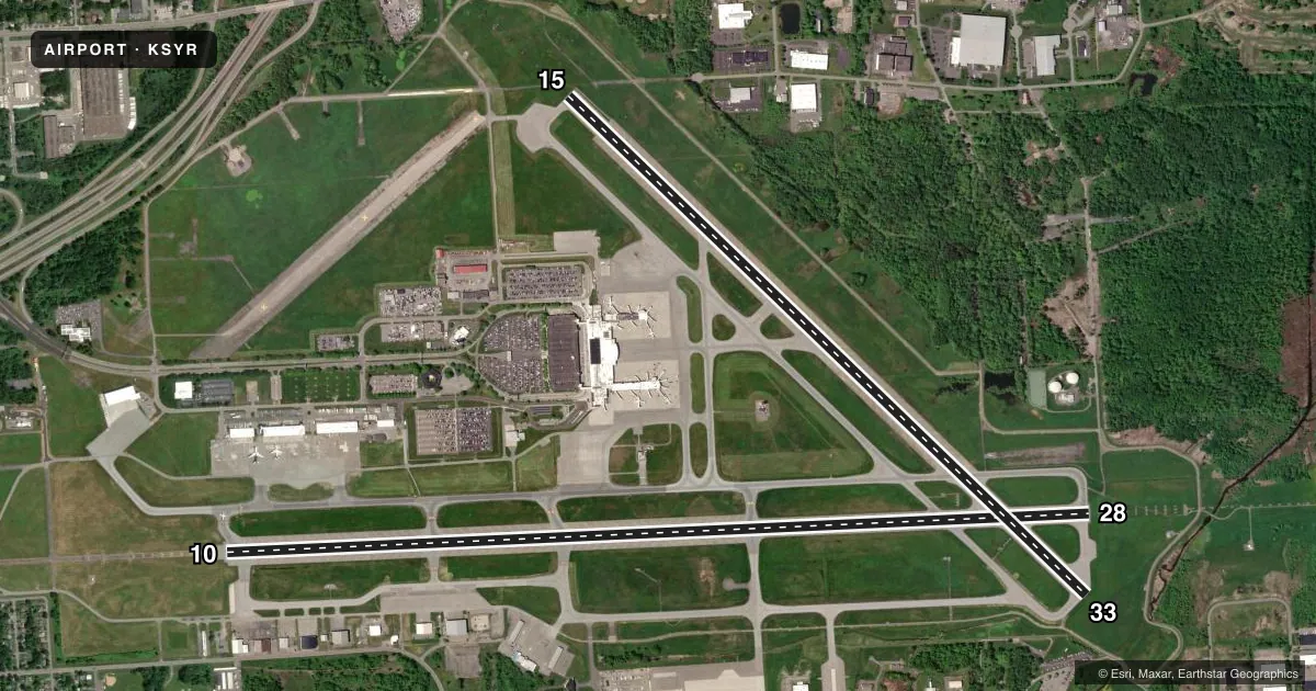
Runways & pattern
Full pagePattern entry · RWY 33
LEFT TRAFFIC| Runway | Heading (°M) | Length | Surface | Traffic |
|---|---|---|---|---|
| 10/28 | 74° / 254° | 9,013 ft | ASPH | Standard L |
| 15/33Favored | 121° / 301° | 7,499 ft | ASPH | Standard L |
Runway end performance
| End | TORA | TODA | ASDA | LDA | VGSI | Approach lights | Obstruction |
|---|---|---|---|---|---|---|---|
| 10 | 9,013' | 9,013' | 9,013' | 9,013' | VASI 4-box left(3°) | MALSR | 64', trees, 2609' from thr, 686' R of cntrln, slope 37 |
| 28 | 9,013' | 9,013' | 9,013' | 9,013' | PAPI 4-box right(3°) | ALSF2 | 80', trees, 2924' from thr, 287' R of cntrln, slope 34 |
| 15 | 7,499' | 7,499' | 7,499' | 7,499' | VASI 4-box left(3°) | MALS | 51', trees, 1440' from thr, 380' R of cntrln, slope 24 |
| 33 | 7,499' | 7,499' | 7,499' | 7,499' | PAPI 4-box left(3°) | — | 34', tree, 840' from thr, 520' R of cntrln, slope 18 |
Declared distances in feet. TORA = takeoff run available, TODA = takeoff distance, ASDA = accelerate-stop, LDA = landing distance.
Airport sketch
Runways drawn to scale from FAA survey coordinates, rendered over satellite imagery. Not for navigation.
Approaches & charts
ILS · 2
Services on the field
Fuel grades, oxygen, maintenance, ramp storage and lighting — as declared to the FAA by the airport operator.
Fuel & services
- Fuel
- 100LLA
- Oxygen (bottled)
- HIGH/LOW
- Oxygen (bulk)
- HIGH/LOW
- Airframe repair
- Not available
- Power plant repair
- Not available
- Other services
- AFRT,AVNCS,CARGO,CHTR,INSTR,RNTL,SALES
Ramp & ground
- Transient storage
- Tie-down
- Hangar
- Landing fee
- No fee published
- Customs
- Not available
- Lighting schedule
- SS-SR
- Beacon schedule
- SS-SR
- Beacon
- White / Green (civil land)(WG)
- Wind indicator
- Lighted
- Segmented circle
- No
Fuel & FBOs
Cheapest 100LL and Jet A on the field and nearby. Always confirm with the FBO before taxi.
Airport notes
Surface conditions, obstructions, local procedures, lighting outages and other notes published with each FAA cycle.
General notes
- NO CHTR OPS THRU PAX TRML BLDG WO PPR.
- NOISE ABATEMENT PROCS IN EFCT.
- DEER/COYOTE/BIRDS ON & INVOF ARPT.
- NO JET ENG MAINT RUNS ABV IDLE BTWN 2300-0600.
- NO TSNT ACFT PRKG ON MAIN TRML RAMP.
- DRCT CUST NOTIFICATION IS RQRD. HRS OF NOTIFICATION ARE MON-SAT 0800-1700. ARRS OUTSIDE OF THESE HRS MUST MAKE ARRANGEMENTS DRG RGLR WORK HRS; CALL 315-455-2271.
- HVY ACFT CTC ARPT COMMISSIONER FOR PRKG AVBL AT C315-455-3263. LTD METRO AVBL AT DSN 243-2185. C315-233-2185 OR CTC OWS DSN 576-9755/9702. ALL TSNT ACFT REQ NOISE ABATEMENT BRIEFING.
- MILITARY: ANG: COMS OPS - 140.425 379.5 RMKS: (COBRA OPS) CTC ANG OPS 15 MIN PRIOR TO ARR.
- RSTD: TWY J & P SOUTH OF TWY Y CLSD TO CIV OPS.
- CTN: TWY J & P SOUTH OF TWY Y & ANG RAMP HAVE UNCTLD VEH & EQPT TFC.
- MILITARY: ANG: OPR 1030-2100Z++ MON-THUR EXC HOL. PPR TSNT ACFT OFFL BUS ONLY. AFLD MGR DSN 243-2399, C315-233-2399, AFT DUTY HR CTC C315-233-2399. PPR REQ FOR ALL TSNT ACFT DUE LTD TSNT SVC. NTFY AFLD MGR OF ETA DLA OVR 30 MIN OR MSN CNL IS RQR.
- MILITARY: ANG: HVY ACFT CTC ARPT COMMISSIONER FOR PRKG AVBL AT C315-455-3666. ALL TSNT ACFT RQR NOISE ABATEMENT BRIEFING.
- UAS OPER WI THE CONFINES OF SYRACUSE CLASS C, TIMES VARY.
- UAS OPS IN SYRACUSE APCH/DEP ASP WILL BE CONTROLLED BY SYR ATC AT ALL TIMES.
- NON-STD MKG ON MIL RAMP.
- ELEVD RWY GUARD LGTS FOR RWY 10-28 AT TWY L, J, N, H, G, M ARE NOT OPR DURG DAY
- ELEVD RWY GUARD LGTS FOR RWY 15-33 AT TWY B, K, S, M ARE NOT OPR DURG DAY.
Runway surface & condition
- 10/28PCR VALUE: 730/F/C/W/T
- 15/33PCR VALUE: 730/F/C/W/T
Approach & departure obstructions
- 33NSTD MRKGS; AIMING POINT MRKGS 1340 FT FM APCH END RWY.
- 28RVRT SENSOR SHARED BY RWY 33.
VFR map & nearby airports
VFR sectional. Tap any ICAO chip to open that airport.
Key facts · KSYR
Answer card- ICAO
- KSYR
- Name
- SYRACUSE HANCOCK INTL
- Location
- SYRACUSE, NEW YORK
- Elevation
- 421.1 ft MSL
- Traffic pattern altitude
- 1,421.1 ft MSL (1,000 AGL)
- Control tower
- Towered · 24
- Total runways
- 2
- Longest runway
- 10/28 · 9,013 ft
- Published ILS approaches
- 2
- Published frequencies
- 16
- Magnetic variation
- 13°
- Current flight rules
- VFR
- Current wind
- 000° at 3 kt
- Favored runway now
- RWY 33
Syracuse Hancock Intl is in Syracuse, New York. The field elevation is 421.1 ft MSL. It has two asphalt runways. The longest is 9,013 ft on 10/28. The tower is open 24 hours. Two ILS approaches are published for runway ends 10 and 28.
For pattern work, the published pattern altitude is not listed in the facts. Use the standard 1,000 ft AGL for light piston traffic unless ATC or the current Chart Supplement says otherwise. That puts you near 1,421 ft MSL based on the field elevation. The airport is busy and has a mix of airline, business and military activity. All transient aircraft require a noise abatement briefing. No transient aircraft parking is permitted on the main terminal ramp. Heavy aircraft should call ahead for parking. The military ramp has nonstandard markings, so taxi carefully if you are unfamiliar with the field.
Freeman Jet Center - Syracuse is on the field. It carries 100LL, Jet A and Jet A Prist. Million Air Syracuse is also on the field. It carries 100LL, Jet A and Jet A Prist. If you are arriving outside normal business hours or need parking help, call the airport operator or the FBO directly before departure. Runway 33 has nonstandard markings. The aiming point markings sit 1,340 ft from the approach end. Runway 28 shares its RVR sensor with runway 33, so expect the field to manage operations with that in mind.