METAR & TAF KSMF
Current METAR
Observed 12:53Z
KSMF 271253Z 15007KT 10SM CLR 16/12 A2993 RMK AO2 SLP136 T01560122
- Wind
- 150° @ 7 kt
- Visibility
- 10 SM
- Temp / Dew
- 16°C / 12°C
- Altimeter
- 29.93 inHg
- Clouds
- CLR
- Density alt
- 141 ft
- Ceiling
- Unlimited
- Rules
- VFR
Airport info & contacts
Manager on record, flight service, ARTCC, attendance schedule and pattern altitude — published by the FAA and refreshed every 28 days.
Location
- From city
- 10 NM NW
- VFR sectional
- SAN FRANCISCO
- ARTCC
- ZOA · OAKLAND
- NOTAM facility
- SMF (NOTAM-D)
Airport manager
- Name
- SHERI THOMPSON-DUARTE
- Phone
- 916-874-0519
- Address
- 6900 AIRPORT BLVD, SACRAMENTO CA 95837
Flight service · Hours
- FSS RIU
- RANCHO MURIETA1-800-WX-BRIEF
- Attendance
- ALL
Frequencies
Tap any row to copy the frequency to your clipboard.
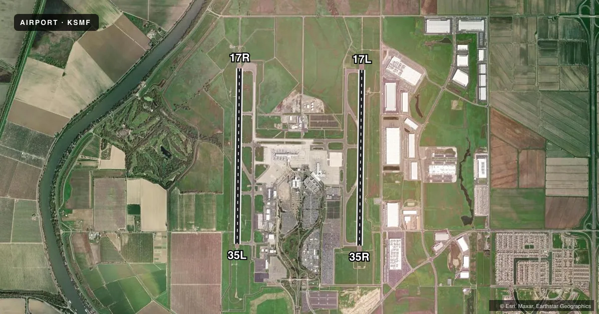
Runways & pattern
Full pagePattern entry · RWY 17L
LEFT TRAFFIC| Runway | Heading (°M) | Length | Surface | Traffic |
|---|---|---|---|---|
| 17L/35RFavored | 168° / 348° | 8,605 ft | CONC | 35R R |
| 17R/35L | 168° / 348° | 8,598 ft | CONC | 17R R |
Runway end performance
| End | TORA | TODA | ASDA | LDA | VGSI | Approach lights | Obstruction |
|---|---|---|---|---|---|---|---|
| 17L | 8,605' | 8,605' | 8,605' | 8,605' | PAPI 4-box left(3°) | MALSR | — |
| 35R | 8,605' | 8,605' | 8,605' | 8,605' | PAPI 4-box left(3°) | — | — |
| 17R | 8,598' | 8,598' | 8,598' | 8,598' | PAPI 4-box right(3°) | ALSF2 | — |
| 35L | 8,598' | 8,598' | 8,598' | 8,598' | PAPI 4-box right(3°) | MALSR | — |
Declared distances in feet. TORA = takeoff run available, TODA = takeoff distance, ASDA = accelerate-stop, LDA = landing distance.
Airport sketch
Runways drawn to scale from FAA survey coordinates, rendered over satellite imagery. Not for navigation.
Approaches & charts
ILS · 3
Services on the field
Fuel grades, oxygen, maintenance, ramp storage and lighting — as declared to the FAA by the airport operator.
Fuel & services
- Fuel
- 100LLA
- Oxygen (bottled)
- Not available
- Oxygen (bulk)
- Not available
- Airframe repair
- Minor
- Power plant repair
- Major
- Other services
- AFRT,CARGO,CHTR
Ramp & ground
- Transient storage
- Tie-down
- Landing fee
- No fee published
- Customs
- Not available
- Beacon schedule
- SS-SR
- Beacon
- White / Green (civil land)(WG)
- Wind indicator
- Lighted
- Segmented circle
- No
Fuel & FBOs
Cheapest 100LL and Jet A on the field and nearby. Always confirm with the FBO before taxi.
Airport notes
Surface conditions, obstructions, local procedures, lighting outages and other notes published with each FAA cycle.
General notes
- BIRDS ON AND IN VICINITY OF ARPT.
- NOISE SENSITIVE AREAS W OF ARPT ON SAC RIVER. LCL TURN DISCOURAGED FOR JET ACFT. WHEN CONDUCTING IFR APCH IN VFR CONDITIONS EXECUTE MISSED APCH AT DEP END OF RYS. PLAN VFR PATTERNS TO E. USE MIN POWER SETTINGS.
- ALL ACFT CTC ATC GND CTL PRIOR TO MOVEMENT ON RAMP.
- CROP DUSTERS OPER INVOF ARPT AT OR BELOW 200 FT AGL.
- TWY RMK #2: THE MAXIMUM ALLOWABLE GROSS AIRCRAFT LOAD FOR TWYS G1, G2, AND THE GENERAL AVIATION PARKING APRON IS: 70,000 LBS FOR SINGLE GEAR AIRCRAFT; 170,000 LBS FOR DUAL GEAR AIRCRAFT; AND 250,000 LBS FOR DUAL TANDEM GEAR AIRCRAFT.
- TWY RMK #2 CONT: AN ACFT CANNOT EXCEED THE AIRPLANE DESIGN GROUP III CRITERIA OR MUST HAVE A WHEEL BASE OF LESS THAN 60 FT.
- MILITARY AIRCRAFT PARKING LIMITED. CONTACT ARPT OPNS IF PARKING IS REQUIRED (916) 806-5309.
- PORTION OF TWY W 500 FT EAST OF TWY A TO 2100 FT EAST OF TWY A IS NOT VISIBLE FROM ATCT.
- TWY Y4 RESTRICTED TO AIRCRAFT WITH A WINGSPAN OF LESS THAN 118 FT (GROUP III).
- UNPAVED SFC NORTH OF TWY P AND EAST OF TWY A AND SOUTH OF CARGO 1 RAMP CLSD TO HEL.
- ACFT MUST PUSH BACK TAIL TO THE NORTH FROM TRML GATES A1, A3 AND A5.
- WEST RAMP SPOTS 63W, 65W, 66 & F1 RSTRD TO TOW IN AND TOW OUT ONLY FROM TXL B2. WHEN PUSHING BACK FOR DEP FROM WEST RAMP SPOTS 63W, 65W, 66 & F1 EACH ACFT IS TO PUSH BACK ONTO TXL B2 AND PULL FWD TO THE ENG START LINE PRIOR TO STARTING ENGS. ADG V ACFT PRKD ON SPOT 66 IS TO PUSH ONTO TWY A AFTER RCVG APVL FROM ATC.
- TWY B1 RSTRD TO ACFT WITH A WINGSPAN OF LESS THAN 118 FT (GROUP III).
Runway surface & condition
- 17L/35RPCR VALUE: 900/R/B/W/T
- 17R/35LPCR VALUE: 840/R/A/W/T
Approach & departure obstructions
- 17RALSF2 OPRS AS SSALR TILL WX GOES BLW VFR.
Other notes
- MANAGERAIRSIDE OPS MGR 916-874-0713; 24HR OPS 916-806-5309.
VFR map & nearby airports
VFR sectional. Tap any ICAO chip to open that airport.
Key facts · KSMF
Answer card- ICAO
- KSMF
- Name
- SACRAMENTO INTL
- Location
- SACRAMENTO, CALIFORNIA
- Elevation
- 26.9 ft MSL
- Traffic pattern altitude
- 1,026.9 ft MSL (1,000 AGL)
- Control tower
- Towered · 24
- Total runways
- 2
- Longest runway
- 17L/35R · 8,605 ft
- Published ILS approaches
- 3
- Published frequencies
- 21
- Magnetic variation
- 13°
- Current flight rules
- VFR
- Current wind
- 150° at 7 kt
- Favored runway now
- RWY 17L
Sacramento Intl sits in Sacramento, California. Field elevation is 26.9 ft MSL. The airport has two concrete runways. The longest is 8,605 ft on 17L/35R. Tower service is 24 hours. Three ILS approaches are published. They serve runway ends 17L, 17R and 35L. Pattern altitude is not published. Use 1,000 ft AGL for light piston traffic unless ATC or the current Chart Supplement says otherwise.
Modern Aviation is on the field. It carries 100LL, Jet A and Jet A Prist. The airport is in NORCAL Class C airspace, so expect radar services and busy arrival flows. Local notes matter here. Ground control must be contacted before any ramp movement. Birds are reported on and near the airport. Noise-sensitive areas lie west of the field on the Sacramento River. Local turns are discouraged for jet aircraft. VFR patterns are planned to the east with minimum power settings. Taxiway Y4 and Taxiway B1 are both limited to aircraft under 118 ft wingspan. A portion of Taxiway W is not visible from the tower. Keep taxi instructions tight. Read back clearly.