METAR & TAF KSDF
Current METAR
Observed 12:56Z
KSDF 271256Z 26003KT 10SM FEW025 FEW040 FEW300 24/21 A2993 RMK AO2 SLP128 T02440211
- Wind
- 260° @ 3 kt
- Visibility
- 10 SM
- Temp / Dew
- 24°C / 21°C
- Altimeter
- 29.93 inHg
- Clouds
- FEW
- Density alt
- 1,689 ft
- Ceiling
- Unlimited
- Rules
- VFR
Airport info & contacts
Manager on record, flight service, ARTCC, attendance schedule and pattern altitude — published by the FAA and refreshed every 28 days.
Location
- From city
- 4 NM S
- VFR sectional
- ST LOUIS
- ARTCC
- ZID · INDIANAPOLIS
- NOTAM facility
- SDF (NOTAM-D)
Airport manager
- Name
- DAN MANN
- Phone
- 502-380-8200
- Address
- 700 ADMINISTRATION DRIVE, LOUISVILLE KY 40209
Flight service · Hours
- FSS LOU
- LOUISVILLE1-800-WX-BRIEF
- Attendance
- ALL
Frequencies
Tap any row to copy the frequency to your clipboard.
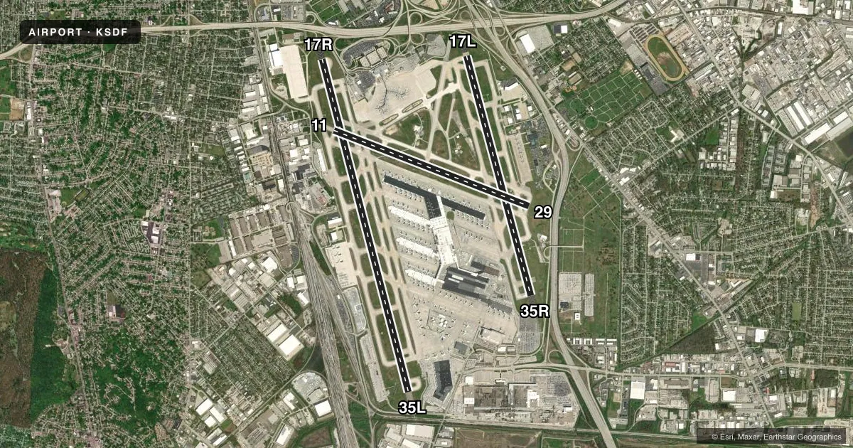
Runways & pattern
Full pagePattern entry · RWY 29
LEFT TRAFFIC| Runway | Heading (°M) | Length | Surface | Traffic |
|---|---|---|---|---|
| 17R/35L | 160° / 340° | 11,887 ft | CONC | Standard L |
| 17L/35R | 160° / 340° | 8,578 ft | CONC | Standard L |
| 11/29Favored | 106° / 286° | 7,251 ft | CONC | Standard L |
Runway end performance
| End | TORA | TODA | ASDA | LDA | VGSI | Approach lights | Obstruction |
|---|---|---|---|---|---|---|---|
| 17R | 11,095' | 11,095' | 11,095' | 10,000' | PAPI 4-box right(3°) | MALSR | — |
| 35L | 11,290' | 11,290' | 11,290' | 10,000' | PAPI 4-box left(3°) | ALSF2 | — |
| 17L | 8,579' | 8,579' | 8,129' | 7,800' | PAPI 4-box left(3°) | MALSR | — |
| 35R | 8,579' | 8,579' | 8,250' | 7,800' | PAPI 4-box right(3°) | ALSF2 | — |
| 11 | 7,250' | 7,250' | 6,946' | 6,946' | PAPI 4-box left(3°) | — | 55', bldg, 1375' from thr, 325' R of cntrln, slope 20 |
| 29 | 7,250' | 7,250' | 7,250' | 7,250' | PAPI 4-box left(3°) | MALSR | — |
Declared distances in feet. TORA = takeoff run available, TODA = takeoff distance, ASDA = accelerate-stop, LDA = landing distance.
Airport sketch
Runways drawn to scale from FAA survey coordinates, rendered over satellite imagery. Not for navigation.
Approaches & charts
ILS · 5
Services on the field
Fuel grades, oxygen, maintenance, ramp storage and lighting — as declared to the FAA by the airport operator.
Fuel & services
- Fuel
- 100LLAA+
- Oxygen (bottled)
- Low pressure
- Oxygen (bulk)
- Not available
- Airframe repair
- Major
- Power plant repair
- Major
- Other services
- AFRT,AVNCS,CARGO,CHTR
Ramp & ground
- Transient storage
- Tie-down
- Hangar
- Landing fee
- No fee published
- Customs
- Not available
- Beacon schedule
- SS-SR
- Beacon
- White / Green (civil land)(WG)
- Wind indicator
- Lighted
- Segmented circle
- No
Fuel & FBOs
Cheapest 100LL and Jet A on the field and nearby. Always confirm with the FBO before taxi.
Airport notes
Surface conditions, obstructions, local procedures, lighting outages and other notes published with each FAA cycle.
General notes
- BIRDS ON & INVOF ARPT.
- CTN: CONST IN PROG; FQT RWY & TWY CLOSURES PSBL.
- ANG/123TAC RECON.
- LINE UP & WAIT WAIVER IN EFCT SS-SR AT INT OF RWY 17R AT TWY B8 OR AT TWY A8 & INT OF RWY 35L AT TWY A OR AT TWY B.
- ANG: DUTY HR 1200-2000Z/DT 1300-2100Z MON-THU; 1200-1800Z/DT 1300-1900Z FRI. APVL AUTH 123 AW/OGC; BASE OPS D741-4581/4584/ C502-413-4581/4584. ENG START & TAXI CLNC - DERBY OPS.
- TAIL HGT 65 FT OR GTR 24 HR PPR.
- ANG: FAA GP 6 ACFT 24 HR PPR.
- MILITARY: CTN: BASH INFO - PHASE I: 1 NOV - 28 FEB AND 1 MAY - 31 AUG; PHASE II: 1 SEPT - 31 OCT AND 1 MAR - 30 APR.
Runway surface & condition
- 11/29PCR VALUE: 720/R/B/W/T
- 17L/35RPCR VALUE: 970/R/B/W/T
- 17R/35LPCR VALUE: 770/R/A/W/T
Approach & departure obstructions
- 17LTWY E INTXN DEP 7700 FT AVBL.
- 17RSTD DEP POINTS AT TWY B8 & TWY A8. REQS USE OF RWY 17R EXTN. TKOF AT TWY B8 ASDA/TORA/TODA 10245 FT.
- 35LSTD DEP POINTS AT TWY A & TWY B; REQS USE OF RWY 35L EXTN; TKOF AT TWY A & TWY B ASDA/TORA/TODA 10250 FT.
- 35RTWY E2 INTXN DEP 6300 FT AVBL.
Other notes
- EXISTED PRIOR TO 1959.
VFR map & nearby airports
VFR sectional. Tap any ICAO chip to open that airport.
Key facts · KSDF
Answer card- ICAO
- KSDF
- Name
- LOUISVILLE MUHAMMAD ALI INTL
- Location
- LOUISVILLE, KENTUCKY
- Elevation
- 500.8 ft MSL
- Traffic pattern altitude
- 1,500.8 ft MSL (1,000 AGL)
- Control tower
- Towered · 24
- Total runways
- 3
- Longest runway
- 17R/35L · 11,887 ft
- Published ILS approaches
- 5
- Published frequencies
- 18
- Magnetic variation
- 5°
- Current flight rules
- VFR
- Current wind
- 260° at 3 kt
- Favored runway now
- RWY 29
Louisville Muhammad Ali Intl sits in Louisville, Kentucky. Field elevation is 500.8 ft MSL. The airport has 3 concrete runways. The longest is 17R/35L at 11,887 ft. The tower is open 24 hours. Five ILS approaches are published here, with coverage to runway ends 17L, 17R, 29, 35L and 35R.
Pattern altitude is not published in the facts. Use the standard 1,000 ft AGL pattern for light piston aircraft unless ATC or the current Chart Supplement says otherwise. Atlantic Aviation is the on-field FBO. It carries 100LL and Jet A. Call (502) 368-1515 for current services.
Plan for a busy Class C environment. The published remarks call out birds in and near the airport. Construction is also listed, with frequent runway and taxiway closures possible. That matters here because the field has three long runways and several published departure points. Runway 17R/35L has a line-up and wait waiver at certain intersections from sunset to sunrise. Runway 17R and 35L also have standard departure points that use the runway extension. If you are operating a tail height of 65 ft or more, the field requires 24-hour prior permission. Check the current FAA Chart Supplement before departure for the latest airport status and any temporary changes.