METAR & TAF KSAC
Current METAR
Observed 12:53Z
KSAC 271253Z AUTO 16003KT 10SM CLR 15/12 A2995 RMK AO2 SLP140 T01500117
- Wind
- 160° @ 3 kt
- Visibility
- 10 SM
- Temp / Dew
- 15°C / 12°C
- Altimeter
- 29.95 inHg
- Clouds
- CLR
- Density alt
- -8 ft
- Ceiling
- Unlimited
- Rules
- VFR
Airport info & contacts
Manager on record, flight service, ARTCC, attendance schedule and pattern altitude — published by the FAA and refreshed every 28 days.
Location
- From city
- 3 NM S
- VFR sectional
- SAN FRANCISCO
- ARTCC
- ZOA · OAKLAND
- NOTAM facility
- SAC (NOTAM-D)
Airport manager
- Name
- RON OGLE
- Phone
- 916-875-9035
- Address
- 6151 FREEPORT BLVD, SACRAMENTO CA 95822
Flight service · Hours
- FSS RIU
- RANCHO MURIETA1-800-WX-BRIEF
- Attendance
- 0800-1600
Frequencies
Tap any row to copy the frequency to your clipboard.
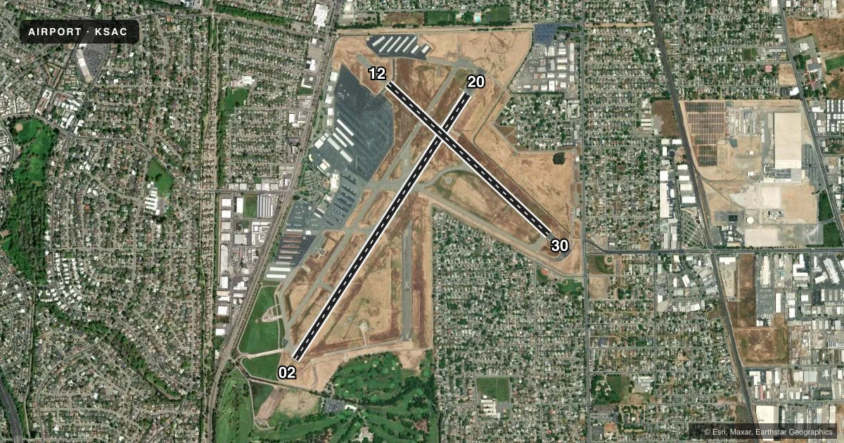
Runways & pattern
Full pagePattern entry · RWY 12
LEFT TRAFFIC| Runway | Heading (°M) | Length | Surface | Traffic |
|---|---|---|---|---|
| 02/20 | 19° / 199° | 5,503 ft | ASPH | Standard L |
| 12/30Favored | 119° / 299° | 3,837 ft | ASPH | Standard L |
Runway end performance
| End | TORA | TODA | ASDA | LDA | VGSI | Approach lights | Obstruction |
|---|---|---|---|---|---|---|---|
| 02 | — | — | — | — | — | MALSR | 33', tree, 1350' from thr, 275' R of cntrln, slope 34 |
| 20 | — | — | — | — | PAPI 4-box left(3°) | — | 40', tree, 1430' from thr, 250' R of cntrln, slope 30 |
| 12 | — | — | — | — | PAPI 4-box left(3°) | — | 40', tree, 1200' from thr, 201' R of cntrln, slope 25 |
| 30 | — | — | — | — | PAPI 4-box left(3.5°) | — | 50', tree, 1050' from thr, 100' R of cntrln, slope 17 |
Declared distances in feet. TORA = takeoff run available, TODA = takeoff distance, ASDA = accelerate-stop, LDA = landing distance.
Airport sketch
Runways drawn to scale from FAA survey coordinates, rendered over satellite imagery. Not for navigation.
Approaches & charts
ILS · 1
Services on the field
Fuel grades, oxygen, maintenance, ramp storage and lighting — as declared to the FAA by the airport operator.
Fuel & services
- Fuel
- 100LLA
- Oxygen (bottled)
- HIGH/LOW
- Oxygen (bulk)
- HIGH/LOW
- Airframe repair
- Major
- Power plant repair
- Major
- Other services
- AFRT,AMB,AVNCS,CHTR,INSTR,RNTL,SALES,SURV
Ramp & ground
- Transient storage
- Tie-down
- Landing fee
- No fee published
- Customs
- Not available
- Lighting schedule
- SEE RMK
- Beacon schedule
- SEE RMK
- Beacon
- White / Green (civil land)(WG)
- Wind indicator
- Lighted
- Segmented circle
- Yes
Fuel & FBOs
Cheapest 100LL and Jet A on the field and nearby. Always confirm with the FBO before taxi.
Airport notes
Surface conditions, obstructions, local procedures, lighting outages and other notes published with each FAA cycle.
General notes
- GOLF COURSE LGTS SHINE ACROSS RY 02 FINAL APCH 800 FT RY CL DUSK TO 2200.
- NO MID-FIELD, INTERSECTION OR FORMATION TKOFS.
- RY 20 CALM WIND RY.
- NO TOUCH & GO LNDGS, LOW APPCHS OR PRACTICE INST APPCHS BTN HRS 2100-0600 LOCAL; FOR MORE INFO CALL (916) 874-0359.
- BIRDS INVOF OF APRT.
- DITCH AND CONCRETE BRIDGE IN RY 02/20 SAFETY AREA LCTD 500 FT PRIOR TO RY 02 THLD ON CL.
- ARPT NOISE ABATEMENT PROCEDURES IN EFFECT 2100-0600 FOR MORE INFO CALL (916) 875-9037 OR (916) 875-9035.
- ARPT 24HR EMERGENCY 916-929-5000.
- PRIOR PERMISSION FROM AIRPORT OPERATOR REQUIRED FOR ACFT OVER 50,000 LBS MAX TAKEOFF WEIGHT.
- DSTC BTN TWY A AND TWY B CNTRLN IS 75 FT.
- RWY 12 BLAST PAD MARKINGS NOT STD.
- FOR CD WHEN ATCT IS CLSD CTC NORCAL APCH AT 916-361-6874.
Lighting notes
- DUSK-DAWN. WHEN ATCT CLSD ACTVT APT BCN - CTAF
- DUSK-DAWN. WHEN ATCT CLSD ACTVT ALL AIRFIELD LGTS - CTAF.
Other notes
- <TPA 1000' EXCP 1500' FOR TURBINE & LARGE ACFT.
- MANAGEROGLER@SACCOUNTY.GOV
- OWNEROPERATED BY CO OF SACRAMENTO
- MANAGERAPT MGR HRS 0800-1630 M-F
VFR map & nearby airports
VFR sectional. Tap any ICAO chip to open that airport.
Key facts · KSAC
Answer card- ICAO
- KSAC
- Name
- SACRAMENTO EXEC
- Location
- SACRAMENTO, CALIFORNIA
- Elevation
- 23.4 ft MSL
- Traffic pattern altitude
- 1,023.4 ft MSL (1,000 AGL)
- Control tower
- Towered · 0600-2100
- Total runways
- 2
- Longest runway
- 02/20 · 5,503 ft
- Published ILS approaches
- 1
- Published frequencies
- 10
- Magnetic variation
- 14°
- Current flight rules
- VFR
- Current wind
- 160° at 3 kt
- Favored runway now
- RWY 12
Sacramento Executive Airport is in Sacramento, California. The field elevation is 23.4 ft MSL. It has two asphalt runways. The longest is runway 02/20 at 5,503 ft. The tower is open daily from 0600 to 2100 local. One ILS approach is published for runway 02.
Pattern altitude is not published. Use 1,000 ft AGL for light piston traffic unless the current Chart Supplement says otherwise. Modern Aviation is on the field. It carries 100LL, Jet A and Jet A Prist. Call ahead at (916) 428-8292 x1 for current service details. The airport is operated by the County of Sacramento.
A few local items matter here. Birds are reported in the area. Runway 20 is listed as the calm wind runway. There is a ditch and concrete bridge in the runway 02/20 safety area 500 ft before the runway 02 threshold on centerline. Golf course lights can shine across the runway 02 final approach path from dusk to 2200. When the tower is closed, use the CTAF to activate all airfield lights from dusk to dawn. No touch-and-go landings, low approaches, or practice instrument approaches are allowed between 2100 and 0600 local. Pilots should also note the airport sits in busy Sacramento airspace. Stay sharp on radio work.