METAR & TAF KPWK
Current METAR
Observed 18:09Z
KPWK 271809Z 14009G15KT 8SM VCTS -RA FEW021 BKN050 OVC065 22/20 A2979 RMK AO2 WSHFT 1739 LTG DSNT ALQDS TSE06 P0009 T02170200 $
- Wind
- 140° @ 9G15 kt
- Visibility
- 8 SM
- Temp / Dew
- 22°C / 20°C
- Altimeter
- 29.79 inHg
- Clouds
- OVC
- Density alt
- 1,803 ft
- Ceiling
- 5,000 ft AGL
- Rules
- VFR
Airport info & contacts
Manager on record, flight service, ARTCC, attendance schedule and pattern altitude — published by the FAA and refreshed every 28 days.
Location
- From city
- 18 NM NW
- VFR sectional
- CHICAGO
- ARTCC
- ZAU · CHICAGO
- NOTAM facility
- PWK (NOTAM-D)
Airport manager
- Name
- JEFF MILLER
- Phone
- 847-537-2580
- Address
- 1020 S. PLANT ROAD, WHEELING IL 60090
Flight service · Hours
- FSS IKK
- KANKAKEE1-800-WX-BRIEF
- Attendance
- ALL
Frequencies
Tap any row to copy the frequency to your clipboard.
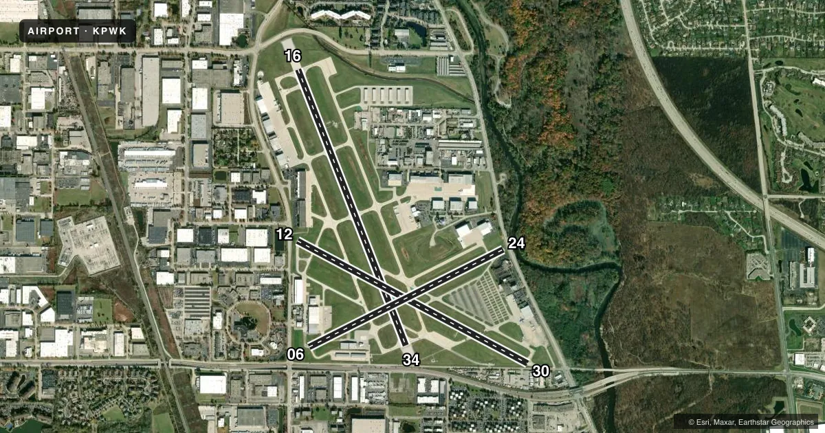
Runways & pattern
Full pagePattern entry · RWY 16
LEFT TRAFFIC| Runway | Heading (°M) | Length | Surface | Traffic |
|---|---|---|---|---|
| 16/34Favored | 157° / 337° | 5,001 ft | ASPH | Standard L |
| 12/30 | 116° / 296° | 4,415 ft | ASPH | 30 R |
Runway end performance
| End | TORA | TODA | ASDA | LDA | VGSI | Approach lights | Obstruction |
|---|---|---|---|---|---|---|---|
| 16 | — | — | — | — | PAPI 4-box left(3°) | RLLS | 24', pole, 629' from thr, 417' R of cntrln, slope 18 |
| 34 | — | — | — | — | PAPI 4-box left(3°) | — | 13', road, 201' from thr, 325' R of cntrln, slope 0 |
| 12 | 4,415' | 4,415' | 4,079' | 3,785' | PAPI 4-box left(3°) | — | 42', tree, 491' from thr, 0' R of cntrln, slope 6 |
| 30 | 4,415' | 4,415' | 4,157' | 3,725' | PAPI 4-box left(3°) | — | 15', road, 201' from thr, 0' R of cntrln, slope 0 |
Declared distances in feet. TORA = takeoff run available, TODA = takeoff distance, ASDA = accelerate-stop, LDA = landing distance.
Airport sketch
Runways drawn to scale from FAA survey coordinates, rendered over satellite imagery. Not for navigation.
Approaches & charts
ILS · 1
Services on the field
Fuel grades, oxygen, maintenance, ramp storage and lighting — as declared to the FAA by the airport operator.
Fuel & services
- Fuel
- 100LLA1+
- Oxygen (bottled)
- HIGH/LOW
- Oxygen (bulk)
- HIGH/LOW
- Airframe repair
- Major
- Power plant repair
- Major
- Other services
- CHTR,INSTR,RNTL
Ramp & ground
- Transient storage
- Tie-down
- Hangar
- Landing fee
- No fee published
- Customs
- Not available
- Lighting schedule
- SEE RMK
- Beacon schedule
- SS-SR
- Beacon
- White / Green (civil land)(WG)
- Wind indicator
- Lighted
- Segmented circle
- Yes
Fuel & FBOs
Cheapest 100LL and Jet A on the field and nearby. Always confirm with the FBO before taxi.
Airport notes
Surface conditions, obstructions, local procedures, lighting outages and other notes published with each FAA cycle.
General notes
- BIRDS & WILDLIFE ON AND INVOF ARPT. PYROTECHNICS, WILDLIFE LASER BIRD CTL IN USE, PLASTIC COYOTE EFFIGIES INVOF A/P.
- NOISE SENSITIVE AREA N & S.
- CONDS NOT RPRTD MON, THU & FRI 2100-0630; TUE, WED & WKEND 1530-0630.
- NOISE ABATEMENT PROC: RWY 34 HOLD PAD PREFERRED TURBINE RUN UP AREA; ALIGN 190 DEG FOR TKOF OR RUN UP. RWY 16 HOLD PAD ALIGN 315 DEG.
- TWY F, P, Q & T EDGE LGT NA; REFLECTORS ONLY.
- HANGAR 5 & 6 APRON, NE T QUARANT, SW T HANGARS PERMITTED TENANT ACFT PRKG ONLY. NO TRANSIENT ACFT PERMITTED.
- NE HNGR TRANSVERSE OPS ENTER TWY Q; EXIT TWY P.
- RWY GUARD LGTS NOT AVBL AT ALL RWY & TWY INTS.
- FOR CD WHEN ATCT CLSD, AND IF UNA ON FREQ, CTC CHICAGO APCH AT 847-289-0926.
- MAINT RUN UP AREA: TXY C ABM ATCT; EXHAUST FACING TWD CNTR OF ARPT. RWY 16 HOLD PAD MAINT RUN NA. TURBINE ENG RUN 2200- 0700 NA. ATCT RADIO CTC RQRD.
- TAXILANE P; TWR VIEW PRLY OBSTD BY HNGRS & TREES. TAXILANE Q AND NE HNGRS; TWR VIEW PRLY OBSTD BY BLDGS & TREES. TWY T AND SW HNGRS; TWR VIEW PRLY OBSTD BY HNGRS. CHARLIE HOLD PAD; TWR VIEW OBSTD BY HNGR 22.
- CUST CLNC 2 HR PPR - 847-894-7292. TSNT UTILIZE FBO AFT CLR CUST. FBO CBP USER FEE.
- ARR ALERT NOTICE PUBLD LNDG NW RWY 34 & RWY 30. VISIT FAA.GOV/AIRPORTS/RUNWAY_SAFETY/HOTSPOTS/AAN/PWK-ARRIVAL-ALERT-NOTICE.PDF
- PRE-PAID ARFF SDBY SER AVBL W/72 HOUR NOTICE VISIT WWW.CHIEXEC.COM OR HTTPS://CHIEXEC.JOTFORM.COM/252055531962052
- RWY SAFETY AREAS USED FOR EMERGENCY TAKE OFF AND LANDING ONLY.
- WHEN SNOW AND/OR ICE REMOVAL OPS NOTAM ACTIVE, FULL STOP TAXI BACKS AND TOUCH AND GOES NOT PERMITTED.
- TWY F CLSD EXC VEHICLES PERMANTLEY.
- AREA 2 CLSD PERM.
Lighting notes
- ACTVT REIL RWY 16 & 34; RLLS RWY 16; HIRL RWY 06/24; 16/34; MIRL RWY 12/30 - CTAF.
Approach & departure obstructions
- 16NSTD SPACING.
- 1215 FT ROAD & 6 FT FENCE.
- 30+6 FT FENCE 0 FT FM THR; +20 FT TREES 0 FT & 50 FT FM THR; 15 FT ROAD.
- 34CTN: WHEN CRCG E FOR R TFC RWY 34 VFY ALNMT; DO NOT MISALIGN WITH RWY 30.
- 16PAPI UNUSBL BYD 8 DEG LEFT & 9 DEG RIGHT OF CNTRLN.
- 34PAPI UNUSBL BYD 8 DEG LEFT & RIGHT OF CNTRLN.
- 12APCH RATIO 20:1 AT DTHR.
- 16CTLG OBSTN EXCEEDS 45 DEG SLP.
- 30APCH RATIO 21:1 AT DTHR.
Arresting gear
- 16_EMASENGINEERED MATERIALS ARRESTING SYSTEM (EMAS) RWY 16 DEP END: 242.97 FT IN LENGTH BY 170.10 FT IN WIDTH, SETBACK 35 FT FROM RWY END.
- 34_EMASENGINEERED MATERIALS ARRESTING SYSTEM (EMAS) RWY 34 DEP END: 230.82 FT IN LENGTH BY 170.10 FT IN WIDTH, SETBACK 304.18 FT FROM RWY END.
Other notes
- ARPT ESTD PRIOR TO 1959. NO OBJECTION FOR ASP ON RWYS 12L/30R & 16/34 ONLY.
- CUST USER FEE. MON-FRI 1100-1900.
VFR map & nearby airports
VFR sectional. Tap any ICAO chip to open that airport.
Key facts · KPWK
Answer card- ICAO
- KPWK
- Name
- CHICAGO EXEC
- Location
- CHICAGO/PROSPECT HEIGHTS/WHEELING, ILLINOIS
- Elevation
- 647 ft MSL
- Traffic pattern altitude
- 1,647 ft MSL (1,000 AGL)
- Control tower
- Towered · 0600-2200 MON-FRI & 0700-2200 SAT-SUN
- Total runways
- 2
- Longest runway
- 16/34 · 5,001 ft
- Published ILS approaches
- 1
- Published frequencies
- 10
- Magnetic variation
- 2°
- Current flight rules
- VFR
- Current wind
- 140° at 9 kt
- Favored runway now
- RWY 16
Chicago Executive Airport sits in Chicago, Prospect Heights and Wheeling, Illinois. Field elevation is 647 ft MSL. The airport has three asphalt runways. The longest is Runway 16/34 at 5,001 ft. The tower is open 0600-2200 Monday through Friday. Weekend hours are 0700-2200 to 2200. One ILS is published for Runway 16. Pattern altitude is not published, so use the standard 1,000 ft AGL for light piston unless ATC or the current Chart Supplement says otherwise.
This is a busy Chicago-area field with towered operations and radio contact required. Expect close attention to taxi instructions and runway assignments. The published remarks also call out arrival alert notice material for landing Runway 34 and Runway 30. Birds and wildlife are reported on and near the airport. Taxiway and hold pad procedures matter here. The Runway 34 hold pad is the preferred turbine run-up area. The Runway 16 hold pad has a published alignment note. Runway guard lights are not available at all runway and taxiway intersections.
Three on-field FBOs are listed. Signature Aviation carries 100LL and Jet A. Atlantic Aviation carries 100LL and Jet A. Ascension FBO carries 100LL, Jet A and Jet A Prist. Check the current Chart Supplement for any noise or curfew restrictions before flying into the field.