METAR & TAF KPSP
Current METAR
Observed 10:53Z
KPSP 271053Z AUTO 00000KT 10SM CLR 31/17 A2983 RMK AO2 SLP094 T03110167
- Wind
- 000° @ 0 kt
- Visibility
- 10 SM
- Temp / Dew
- 31°C / 17°C
- Altimeter
- 29.83 inHg
- Clouds
- CLR
- Density alt
- 2,623 ft
- Ceiling
- Unlimited
- Rules
- VFR
Airport info & contacts
Manager on record, flight service, ARTCC, attendance schedule and pattern altitude — published by the FAA and refreshed every 28 days.
Location
- From city
- 2 NM E
- VFR sectional
- LOS ANGELES
- ARTCC
- ZLA · LOS ANGELES
- NOTAM facility
- PSP (NOTAM-D)
Airport manager
- Name
- HARRY BARRETT
- Phone
- 760-318-3800
- Address
- 3400 E. TAHQUITZ-CANYON WAY, SUITE OFC, PALM SPRINGS CA 92262
Flight service · Hours
- FSS RAL
- RIVERSIDE1-800-WX-BRIEF
- Attendance
- ALL
Frequencies
Tap any row to copy the frequency to your clipboard.
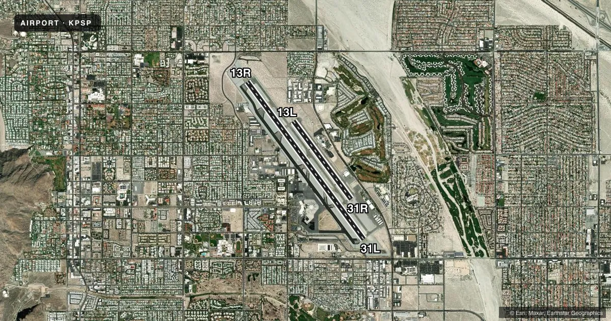
Runways & pattern
Full pagePattern entry · RWY 13R
LEFT TRAFFIC| Runway | Heading (°M) | Length | Surface | Traffic |
|---|---|---|---|---|
| 13R/31L | 130° / 310° | 10,000 ft | ASPH | 31L R |
| 13L/31R | 130° / 310° | 4,953 ft | ASPH | 31R R |
Runway end performance
| End | TORA | TODA | ASDA | LDA | VGSI | Approach lights | Obstruction |
|---|---|---|---|---|---|---|---|
| 13R | 10,000' | 10,000' | 9,857' | 6,857' | PAPI 4-box left(3°) | — | — |
| 31L | 10,000' | 10,000' | 10,000' | 8,500' | PAPI 4-box right(3°) | — | — |
| 13L | 4,953' | 4,953' | 4,953' | 4,953' | PAPI 4-box left(3.2°) | — | — |
| 31R | 4,953' | 4,953' | 4,953' | 4,953' | PAPI 4-box left(3.2°) | — | — |
Declared distances in feet. TORA = takeoff run available, TODA = takeoff distance, ASDA = accelerate-stop, LDA = landing distance.
Airport sketch
Runways drawn to scale from FAA survey coordinates, rendered over satellite imagery. Not for navigation.
Approaches & charts
Services on the field
Fuel grades, oxygen, maintenance, ramp storage and lighting — as declared to the FAA by the airport operator.
Fuel & services
- Fuel
- 100LLA
- Oxygen (bottled)
- Low pressure
- Airframe repair
- Major
- Power plant repair
- Major
- Other services
- AFRT,CHTR,INSTR,RNTL,SALES
Ramp & ground
- Transient storage
- Tie-down
- Hangar
- Landing fee
- No fee published
- Customs
- Not available
- Lighting schedule
- SEE RMK
- Beacon schedule
- SS-SR
- Beacon
- White / Green (civil land)(WG)
- Wind indicator
- Lighted
- Segmented circle
- Yes
Fuel & FBOs
Cheapest 100LL and Jet A on the field and nearby. Always confirm with the FBO before taxi.
Airport notes
Surface conditions, obstructions, local procedures, lighting outages and other notes published with each FAA cycle.
General notes
- NOISE SENSITIVE AREA ALL QUADRANTS; EXERCISE QUIET FLT PROCEDURES. FOR FURTHER INFO CTC DUTY SUPERVISOR (760) 318-3820.
- RY 13R DESIGNATED CALM WIND RY.
- NO FORMATION LDGS OR TAKEOFFS OR OVERHEAD MANEUVERS
- ACCESS TO/FROM FBO RAMP VIA TWY G LMTD TO ACFT WITH WINGSPAN OF LESS THAN 40 FT.
- LENGTHY ENG IDLING AND RUN-UPS ON RAMP AREA PROHIBITED. CTC ARPT OPS 760-318-3820 FOR NOISE MEDIATION PROCEDURES.
- RWY 13L/31R LGTD DIST RMNG MKRS ON E SIDE ONLY. RWY 13R/31L LGTD DIST RMNG MKRS ON W SIDE ONLY.
- DO NOT MISTAKE CENTER TWY (TWY C) AS RWY 13R/31L.
- FOR CD WHEN ATCT CLSD CTC SOCAL APCH AT 800-448-3724.
Lighting notes
- WHEN TWR CLSD ACTVT REIL RWY 13R & 31L; PAPI RWY 13R & 31L; HIRL RWY 13R/31L - CTAF. REIL RWY 13L & 31R; PAPI RWY 13L & 31R; MIRL RWY 13L/31R; TWY E NOT LGTD WHEN TWR CLSD.
Runway surface & condition
- 13L/31RPCR VALUE: 140/F/C/X/T
- 13R/31LPCR VALUE: 450/F/B/X/T
Approach & departure obstructions
- 13RRISING TERRAIN N OF APCH END OF RY 13R.
- 13RUNUSBL BYD 9 DEGS LEFT OF CNTRLN
- 31LRWY 31L PAPI UNUSBL BYD 4 NM FROM THLD DUE TO MOUNTAINOUS TER
- 31RUNUSBL BYD 8 DEGS RIGHT OF CNTRLN AND BYD 4 NM FROM THR DUE TO MOUNTAINOUS TRRN.
- 13RAPCH RATIO 50:1 TO DSPLCD THR.
- 31LAPCH RATIO 50:1 TO DSPLCD THR.
Other notes
- TPA: 1,500 FT. AGL LARGE ACFT, 1,000 FT AGL SMALL ACFT.
- US CUSTOMS AVBL 24 HRS; 4 HRS PRIOR NOTIFICATION REQD, CALL (760) 318-3880, FAX 3883.
VFR map & nearby airports
VFR sectional. Tap any ICAO chip to open that airport.
Key facts · KPSP
Answer card- ICAO
- KPSP
- Name
- PALM SPRINGS INTL
- Location
- PALM SPRINGS, CALIFORNIA
- Elevation
- 476.6 ft MSL
- Traffic pattern altitude
- 1,476.6 ft MSL (1,000 AGL)
- Control tower
- Towered · 0600-2300
- Total runways
- 2
- Longest runway
- 13R/31L · 10,000 ft
- Published ILS approaches
- 0
- Published frequencies
- 17
- Magnetic variation
- 13°
- Current flight rules
- VFR
- Current wind
- 000° at 0 kt
- Favored runway now
- –
Palm Springs Intl is in Palm Springs, California. Field elevation is 476.6 ft MSL. The airport has two asphalt runways. The longest is 13R/31L at 10,000 ft. The control tower is open from 0600 to 2300. No ILS approaches are published here.
Pattern altitude is 1,500 ft AGL for large aircraft. Pattern altitude is 1,000 ft AGL for small aircraft. That matters here because the airport sits in a noise-sensitive area in all quadrants. Fly quiet and keep the published restrictions in mind. Formation landings, formation takeoffs and overhead maneuvers are not permitted. Runway 13R is the calm wind runway. There is rising terrain north of the approach end of runway 13R. Runway 31L PAPI is unusable beyond 4 NM from the threshold because of mountainous terrain.
Atlantic Aviation and Signature Aviation are on the field. Both carry 100LL and Jet A. When the tower is closed, use CTAF for the published lighting setup. Taxiway E is not lighted when the tower is closed. U.S. Customs is available 24 hours with 4 hours prior notification. Access to and from the FBO ramp via taxiway G is limited to aircraft with wingspan under 40 feet. Do not mistake center taxiway C for runway 13R/31L.