METAR & TAF KMSP
Current METAR
Observed 21:53Z
KMSP 272153Z 33013G20KT 9SM FEW040 37/16 A2971 RMK AO2 SLP050 T03720156
- Wind
- 330° @ 13G20 kt
- Visibility
- 9 SM
- Temp / Dew
- 37°C / 16°C
- Altimeter
- 29.71 inHg
- Clouds
- FEW
- Density alt
- 3,944 ft
- Ceiling
- Unlimited
- Rules
- VFR
Airport info & contacts
Manager on record, flight service, ARTCC, attendance schedule and pattern altitude — published by the FAA and refreshed every 28 days.
Location
- From city
- 6 NM S
- VFR sectional
- TWIN CITIES
- ARTCC
- ZMP · MINNEAPOLIS
- NOTAM facility
- MSP (NOTAM-D)
Airport manager
- Name
- BRIAN RYKS
- Phone
- 612-726-8100
- Address
- 6040 28TH AVE S, MINNEAPOLIS MN 55450-2799
Flight service · Hours
- FSS PNM
- PRINCETON1-800-WX-BRIEF
- Attendance
- ALL
Frequencies
Tap any row to copy the frequency to your clipboard.
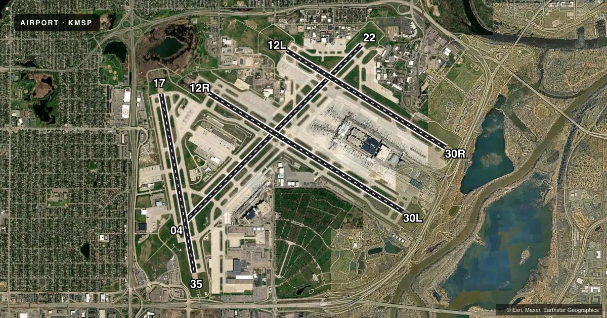
Runways & pattern
Full pagePattern entry · RWY 35
LEFT TRAFFIC| Runway | Heading (°M) | Length | Surface | Traffic |
|---|---|---|---|---|
| 04/22 | 45° / 225° | 11,006 ft | CONC | Standard L |
| 12R/30L | 121° / 301° | 10,000 ft | CONC | Standard L |
| 12L/30R | 121° / 301° | 8,200 ft | CONC | Standard L |
| 17/35Favored | 170° / 350° | 8,000 ft | CONC | Standard L |
Runway end performance
| End | TORA | TODA | ASDA | LDA | VGSI | Approach lights | Obstruction |
|---|---|---|---|---|---|---|---|
| 04 | 11,006' | 11,006' | 11,006' | 9,456' | PAPI 4-box left(3°) | MALSR | 101', tree, 2906' from thr, 834' R of cntrln, slope 26 |
| 22 | 11,006' | 11,006' | 11,006' | 10,006' | PAPI 4-box left(3°) | MALSR | 66', tree, 1350' from thr, 636' R of cntrln, slope 17 |
| 12R | 10,000' | 10,000' | 10,000' | 10,000' | PAPI 4-box left(3°) | ALSF2 | — |
| 30L | 10,000' | 10,000' | 10,000' | 10,000' | PAPI 4-box left(3°) | ALSF2 | 36', tree, 1477' from thr, 562' R of cntrln, slope 35 |
| 12L | 8,200' | 8,200' | 7,620' | 7,620' | PAPI 4-box left(3°) | ALSF2 | 61', tree, 3011' from thr, 667' R of cntrln, slope 46 |
| 30R | 8,200' | 8,200' | 8,200' | 8,000' | PAPI 4-box left(3°) | MALSF | 13', tree, 808' from thr, 272' R of cntrln, slope 46 |
| 17 | 8,000' | 8,000' | 8,000' | 8,000' | PAPI 4-box right(3°) | — | 52', tree, 1990' from thr, 732' R of cntrln, slope 34 |
| 35 | 8,000' | 8,000' | 8,000' | 8,000' | PAPI 4-box left(3°) | ALSF2 | — |
Declared distances in feet. TORA = takeoff run available, TODA = takeoff distance, ASDA = accelerate-stop, LDA = landing distance.
Airport sketch
Runways drawn to scale from FAA survey coordinates, rendered over satellite imagery. Not for navigation.
Approaches & charts
ILS · 8
Services on the field
Fuel grades, oxygen, maintenance, ramp storage and lighting — as declared to the FAA by the airport operator.
Fuel & services
- Fuel
- 100LLAA++
- Oxygen (bottled)
- High pressure
- Oxygen (bulk)
- High pressure
- Airframe repair
- Major
- Power plant repair
- Major
- Other services
- AFRT,AVNCS,CARGO,CHTR
Ramp & ground
- Transient storage
- Tie-down
- Hangar
- Landing fee
- Yes
- Customs
- Not available
- Beacon schedule
- SS-SR
- Beacon
- White / Green (civil land)(WG)
- Wind indicator
- Lighted
- Segmented circle
- No
Fuel & FBOs
Cheapest 100LL and Jet A on the field and nearby. Always confirm with the FBO before taxi.
Airport notes
Surface conditions, obstructions, local procedures, lighting outages and other notes published with each FAA cycle.
General notes
- TRNG FLTS PROHIBITED. GA FLTS MUST TRMT AT THE FBO OR US CUSTOMS UNLESS APVD BY AMGR.
- NOISE ABATEMENT PROCEDURES - 612-726-9411. NO STAGE 1 CAT CIVIL ACFT. NIGHT HR 2230-0600.
- BIRDS ON & INVOF ARPT.
- SIGNATURE FLIGHT SUPPORT 128.95
- MILITARY: ARFC 934 AW OPS 1300-0400Z++ MON-THUR, 1300-2200Z++ FRI, CLSD WKEND AND FEDERAL HOL. UNIT TRNG ASSEMBLY (UTA) WKEND 1330-2200Z++. ALL TRANS ACFT MUST RECEIVE PPR 72 HR PRIOR TO ETA - CTC AIRFIELD MGMT.
- MILITARY RSTD: NO HAZ CL/DIV1.1 OR 1.2 EXPLOSIVES PERMITTED. LOADING OR UNLOADING OF HAZ CL/DIV 1.3, 1.4, 1.5 0R 1.6 MUST BE APV BY ARPT DRCT PRIOR TO FLT.
- 133 AW AFLD MGMT - 324.1 REMARKS: CALL LIGHTHOUSE.
- COMMUNICATIONS: MINNEAPOLIS AIR RESERVE STATION JOINT COMD POST - 252.1 REMARKS: CALL NORTHSTAR.
- 934 AW AFLD MGMT - PTD 282.675 REMARKS: CALL VIKING OPS.
- REMARKS: ALL ACFT MUST CTC NORTHSTAR ON FREQ 252.1 20 MIN PRIOR ARR.
- UNSKED ACFT AT TRML 2-HUMPHREY REQ TO CTC TRML 2 GATE CONTROL ON 122.95 OR CALL 612-726-5742 PRIOR TO ARR.
- ALL GROUP VI ACFT WITH WINGSPAN GREATER THAN 214 FT PPR REQ PRIOR TO ARR - CTC AIRSIDE OPS 612-726-5111.
- RWY STATUS LGTS IN OPRN.
- ALL GA ACFT WITH LESS THAN 20 PAX THAT NEED TO CLEAR US CUSTOMS SHOULD CTC SIGNATURE FLT SUPPORT 128.95 OR 612-726-5700 PRIOR TO ARR.
- ALL GROUP IV AND LRGR ACFT OPRG ON THE PTN OF TWY S ADJ TO DELTA BLDG C RQR THE USE OF WINGWALKERS AND THAT THE VEHICLE SVC ROAD BE CLEAR OF VEHICLES.
- AFRC - PPR ALL ACFT 72 HR PN RQR.
Fuel notes
- 100LLFUEL CIV RAMP A+; NC-100LL - 612-726-5700.
- A++FUEL MIL RAMP - MILOPS.
Runway surface & condition
- 12L/30RPCR VALUE: 2160/R/D/W/T
- 04/22PCR VALUE: 1350/R/D/W/T
- 12R/30LPCR VALUE: 2010/R/D/W/T
- 17/35PCR VALUE: 1840/R/D/W/T
Approach & departure obstructions
- 228 FT FENCE, 500 FT R.
- 04APCH RATIO 43:1 TO DTHR OVR 102 FT TREE, 4456 FT DIST, 834 FT L.
- 22APCH RATIO 34:1 TO DTHR OVR 70 FT TREE, 2337 FT DIST, 439 FT R.
Arresting gear
- 12R_EMASENGINEERED MATERIALS ARRESTING SYSTEM (EMAS) 160 FT IN LENGTH BY 216 FT IN WIDTH LCTD AT DER 12R.
VFR map & nearby airports
VFR sectional. Tap any ICAO chip to open that airport.
Key facts · KMSP
Answer card- ICAO
- KMSP
- Name
- MINNEAPOLIS-ST PAUL INTL/WOLD-CHAMBERLAIN
- Location
- MINNEAPOLIS, MINNESOTA
- Elevation
- 841.8 ft MSL
- Traffic pattern altitude
- 1,841.8 ft MSL (1,000 AGL)
- Control tower
- Towered · 24
- Total runways
- 4
- Longest runway
- 04/22 · 11,006 ft
- Published ILS approaches
- 8
- Published frequencies
- 29
- Magnetic variation
- 0°
- Current flight rules
- VFR
- Current wind
- 330° at 13 kt
- Favored runway now
- RWY 35
KMSP is in Minneapolis, Minnesota. The field elevation is 841.8 ft MSL. This is a busy towered airport with 24-hour control. It has four concrete runways. The longest is 04/22 at 11,006 ft. Eight ILS approaches are published. They serve runway ends 04, 12L, 12R, 17, 22, 30L, 30R and 35.
Pattern altitude is not published in the facts. Use the standard 1,000 ft AGL for light piston traffic unless ATC or the current Chart Supplement says otherwise. That puts the pattern at about 1,842 ft MSL based on the field elevation. Verify before you fly. Magnetic variation is 0°. The runway numbers line up closely with true headings.
Signature Aviation is on the field. It carries 100LL, Jet A and Jet A Prist. The published remarks also note runway status lights in operation. Birds are reported on and near the airport. Keep a sharp scan on departure and arrival. The airport also has military activity. Transient aircraft need prior permission for those operations. Check the current Chart Supplement and call the airport operator or FBO directly if your trip overlaps that traffic.
One runway note matters for planning. The approach to 22 has a published obstruction note tied to a displaced threshold. If you are new to KMSP, brief the runway layout and taxi flow before you go. This is a large Class B airport with heavy traffic. Expect close coordination with ATC.