METAR & TAF KMOB
Current METAR
Observed 15:56Z
KMOB 271556Z 31008KT 10SM FEW050 BKN090 BKN250 33/24 A2999 RMK AO2 SLP151 T03330239
- Wind
- 310° @ 8 kt
- Visibility
- 10 SM
- Temp / Dew
- 33°C / 24°C
- Altimeter
- 29.99 inHg
- Clouds
- BKN
- Density alt
- 2,344 ft
- Ceiling
- 9,000 ft AGL
- Rules
- VFR
Airport info & contacts
Manager on record, flight service, ARTCC, attendance schedule and pattern altitude — published by the FAA and refreshed every 28 days.
Location
- From city
- 11 NM W
- VFR sectional
- NEW ORLEANS
- Pattern altitude
- 800 ft AGL · 1,019 ft MSL
- ARTCC
- ZHU · HOUSTON
- NOTAM facility
- MOB (NOTAM-D)
Airport manager
- Name
- ANDY WILSON
- Phone
- 251-633-4510
- Address
- P O BOX 88004, MOBILE AL 36608-0004
Flight service · Hours
- FSS ANB
- ANNISTON1-800-WX-BRIEF
- Attendance
- ALL
Frequencies
Tap any row to copy the frequency to your clipboard.
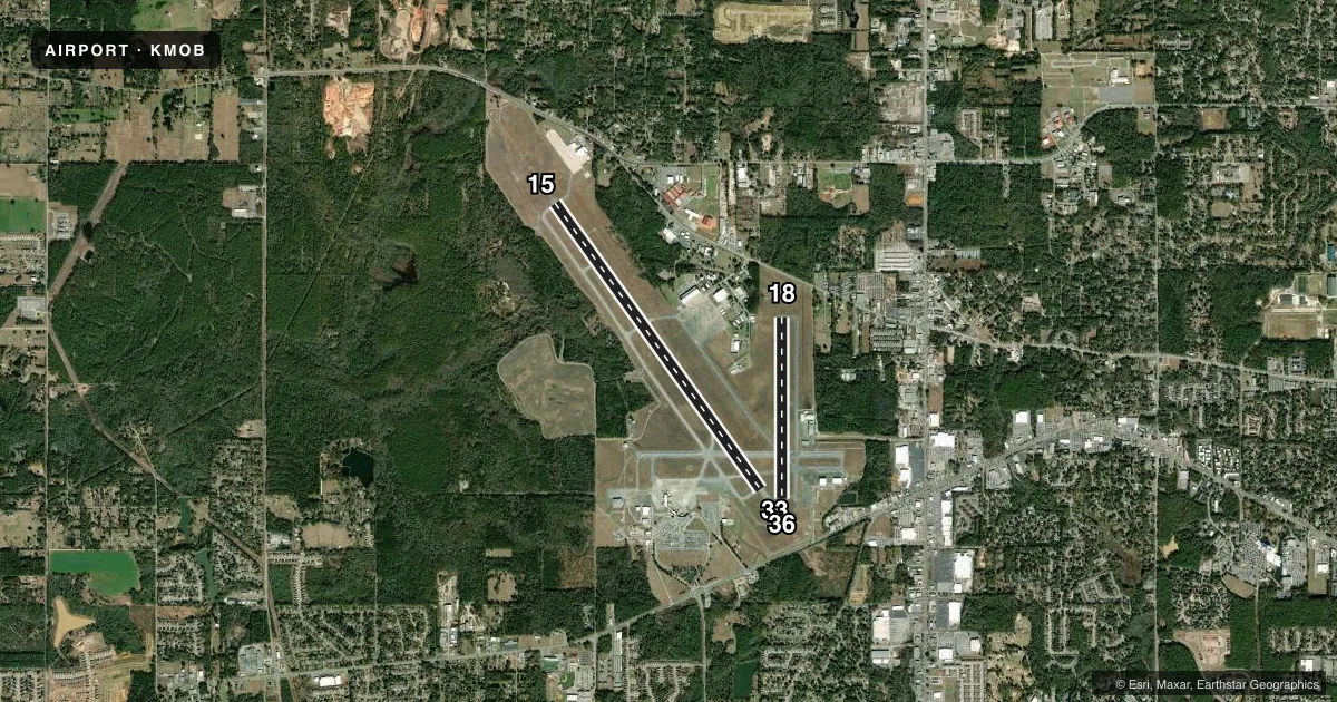
Runways & pattern
Full pagePattern entry · RWY 33
LEFT TRAFFIC| Runway | Heading (°M) | Length | Surface | Traffic |
|---|---|---|---|---|
| 15/33Favored | 141° / 321° | 8,502 ft | ASPH | Standard L |
| 18/36 | 177° / 357° | 4,376 ft | ASPH | Standard L |
Runway end performance
| End | TORA | TODA | ASDA | LDA | VGSI | Approach lights | Obstruction |
|---|---|---|---|---|---|---|---|
| 15 | — | — | — | — | PAPI 4-box left(3°) | MALSR | — |
| 33 | — | — | — | — | PAPI 4-box left(3°) | MALSR | — |
| 18 | — | — | — | — | — | — | 32', tree, 850' from thr, 50' R of cntrln, slope 25 |
| 36 | — | — | — | — | — | — | 62', trees, 1760' from thr, 200' R of cntrln, slope 25 |
Declared distances in feet. TORA = takeoff run available, TODA = takeoff distance, ASDA = accelerate-stop, LDA = landing distance.
Airport sketch
Runways drawn to scale from FAA survey coordinates, rendered over satellite imagery. Not for navigation.
Approaches & charts
ILS · 2
Services on the field
Fuel grades, oxygen, maintenance, ramp storage and lighting — as declared to the FAA by the airport operator.
Fuel & services
- Fuel
- 100LLAA+
- Oxygen (bottled)
- Low pressure
- Oxygen (bulk)
- Low pressure
- Airframe repair
- Major
- Power plant repair
- Major
- Other services
- AFRT,AMB,AVNCS,CARGO,CHTR,INSTR,RNTL,SALES
Ramp & ground
- Transient storage
- Tie-down
- Hangar
- Landing fee
- Yes
- Customs
- Not available
- Lighting schedule
- SEE RMK
- Beacon schedule
- SS-SR
- Beacon
- White / Green (civil land)(WG)
- Wind indicator
- Lighted
- Segmented circle
- Yes
Fuel & FBOs
Cheapest 100LL and Jet A on the field and nearby. Always confirm with the FBO before taxi.
Airport notes
Surface conditions, obstructions, local procedures, lighting outages and other notes published with each FAA cycle.
General notes
- RVR UNAVBL WHEN ATCT CLSD.
- COAST GUARD; W APRON , E APRON.
- CONDS NOT MNTD WHEN ATCT CLSD.
- FOR CD IF UNA TO CTC ON FSS FREQ, CTC HOUSTON ARTCC AT 281-230-5622.
- MOB TWY C BTN TWY A AND TWY C3 CLSD TO ACFT WINGSPAN MORE THAN 78FT
Lighting notes
- WHEN ATCT CLSD ACTVT MALSR RWYS 15 & 33 - CTAF. PAPI RWYS 15 & 33 OPR CONSLY. HIRL RWY 15/33 PRESET STEP 3 OR HYR, BASED ON WX CONDS.
Runway surface & condition
- 18/36RWY 18/36 NOT AVBL FOR PART 121/PART 380 OPS WITH SKED PAX CARRYING OPS MORE THAN 9 PAX SEATS AND NON-SKED PAX CARRYING OPS MORE THAN 30 PAX SEATS. CLSD 2200-0700 EXCP FOR EMERG OPNS.
- H3MIL USE ONLY HELIPAD LCTD AT USCG APRON.
Other notes
- THIS AIRPORT HAS BEEN SURVEYED BY THE NATIONAL GEODETIC SURVEY.
- ARPT CONSTD PRIOR TO FAA ACT. AIRSPACE ACTION NOT ON FILE.
- LNDG FEE FOR NON-SKED COML ACFT OVR 65000 LBS.
- TPA: HEL/SNGL SRS CAT I 800 FT AGL, 1300 FT AGL FIXED WING ACFT, OVHD 1800 FT AGL.
VFR map & nearby airports
VFR sectional. Tap any ICAO chip to open that airport.
Key facts · KMOB
Answer card- ICAO
- KMOB
- Name
- MOBILE RGNL
- Location
- MOBILE, ALABAMA
- Elevation
- 218.7 ft MSL
- Traffic pattern altitude
- 1,018.7 ft MSL (800 AGL)
- Control tower
- Towered · 0600-2300
- Total runways
- 2
- Longest runway
- 15/33 · 8,502 ft
- Published ILS approaches
- 2
- Published frequencies
- 19
- Magnetic variation
- 3°
- Current flight rules
- VFR
- Current wind
- 310° at 8 kt
- Favored runway now
- RWY 33
Mobile Rgnl sits in Mobile, Alabama. Field elevation is 218.7 ft MSL. The airport has 2 asphalt runways. The longest is 8,502 ft on 15/33. Tower service runs from 0600 to 2300. Two ILS approaches are published. They serve runway ends 15 and 33.
Pattern altitude is 800 ft AGL, which is 1,018.7 ft MSL. The published remarks also call out a different overhead pattern for fixed-wing traffic at 1,800 ft AGL. Check the current Chart Supplement before you go if you plan to use the pattern. Signature Aviation is on the field. It carries 100LL, Jet A and Jet A Prist. For clearance delivery issues, the published remarks say to contact Houston ARTCC if Flight Service is not available.
A few operational items matter here. Runway 18/36 is closed from 2200 to 0700 except for emergency operations. The airport also notes that runway 18/36 is not available for certain large passenger-carrying operations. Taxiway C between taxiway A and taxiway C3 is closed to aircraft with wingspan over 78 ft. The field was built before the FAA Act. Check the current Chart Supplement for the latest airspace and airport notes before departure.