METAR & TAF KMNM
Current METAR
Observed 17:57Z
KMNM 271757Z AUTO 18014G23KT 10SM CLR 23/20 A2966 RMK AO2 SLP039 60084 T02330200 10250 20200 58025 $
- Wind
- 180° @ 14G23 kt
- Visibility
- 10 SM
- Temp / Dew
- 23°C / 20°C
- Altimeter
- 29.66 inHg
- Clouds
- CLR
- Density alt
- 2,057 ft
- Ceiling
- Unlimited
- Rules
- VFR
Airport info & contacts
Manager on record, flight service, ARTCC, attendance schedule and pattern altitude — published by the FAA and refreshed every 28 days.
Location
- From city
- 1 NM NW
- VFR sectional
- GREEN BAY
- ARTCC
- ZMP · MINNEAPOLIS
- NOTAM facility
- MNM (NOTAM-D)
Airport manager
- Name
- JEFF LAFLEUR
- Phone
- 715-938-2006
- Address
- 2801 22ND ST, MENOMINEE MI 49858-3401
Flight service · Hours
- FSS GRB
- GREEN BAY1-800-WX-BRIEF
- Attendance
- MON-FRI · 0800-1600
Frequencies
Tap any row to copy the frequency to your clipboard.
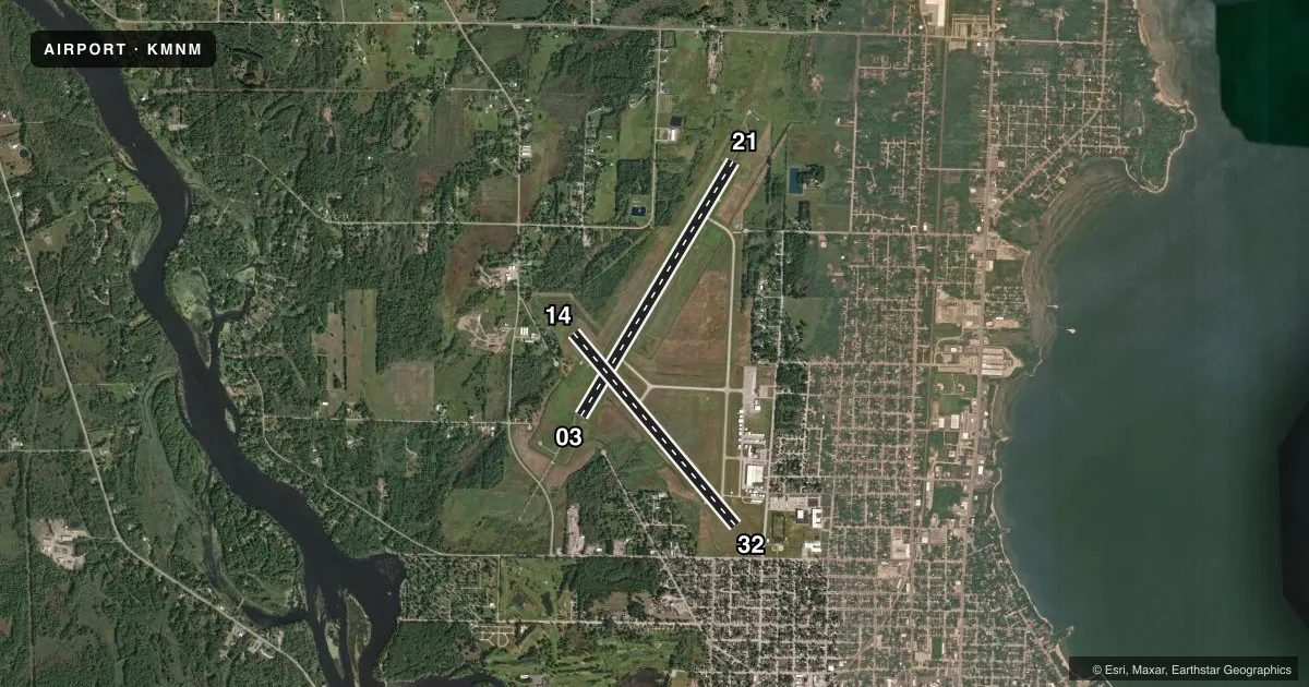
Runways & pattern
Full pagePattern entry · RWY 21
LEFT TRAFFIC| Runway | Heading (°M) | Length | Surface | Traffic |
|---|---|---|---|---|
| 03/21Favored | 28° / 208° | 6,001 ft | ASPH | Standard L |
| 14/32 | 137° / 317° | 5,101 ft | ASPH | Standard L |
Runway end performance
| End | TORA | TODA | ASDA | LDA | VGSI | Approach lights | Obstruction |
|---|---|---|---|---|---|---|---|
| 03 | — | — | — | — | — | MALSR | — |
| 21 | — | — | — | — | PAPI 4-box left(3°) | — | — |
| 14 | — | — | — | — | PAPI 4-box right(4°) | — | 57', trees, 910' from thr, 400' R of cntrln, slope 12 |
| 32 | — | — | — | — | PAPI 4-box left(4°) | — | 51', tree, 739' from thr, 238' R of cntrln, slope 10 |
Declared distances in feet. TORA = takeoff run available, TODA = takeoff distance, ASDA = accelerate-stop, LDA = landing distance.
Airport sketch
Runways drawn to scale from FAA survey coordinates, rendered over satellite imagery. Not for navigation.
Approaches & charts
ILS · 1
Services on the field
Fuel grades, oxygen, maintenance, ramp storage and lighting — as declared to the FAA by the airport operator.
Fuel & services
- Fuel
- 100LLA+
- Oxygen (bottled)
- HIGH/LOW
- Oxygen (bulk)
- Not available
- Airframe repair
- Major
- Power plant repair
- Major
- Other services
- INSTR,RNTL
Ramp & ground
- Transient storage
- Tie-down
- Hangar
- Landing fee
- No fee published
- Customs
- Not available
- Lighting schedule
- SEE RMK
- Beacon schedule
- SS-SR
- Beacon
- White / Green (civil land)(WG)
- Wind indicator
- Lighted
- Segmented circle
- No
Fuel & FBOs
Cheapest 100LL and Jet A on the field and nearby. Always confirm with the FBO before taxi.
Airport notes
Surface conditions, obstructions, local procedures, lighting outages and other notes published with each FAA cycle.
General notes
- DEER, BIRDS, & WILDLIFE ON & INVOF ARPT.
Lighting notes
- ACTVT MALSR RWY 03; REIL RWY 21; PAPI RWY 21, 14, & 32; HIRL RWY 03/21; MIRL RWY 14/32 - CTAF.
Fuel notes
- 100LL100LL AVBL H24 SELF SVC VIA CREDIT CARD.
Runway surface & condition
- 03/21PCR VALUE: 365/F/D/X/T
Other notes
- ROPES NOT PRVDD.
- 1FOR ATTENDANT AFT HRS CALL AMGR, IF UNA CALL ASST MGR CELL 262-365-1991.
- MANAGERCELL. ASST AMGR CELL 262-365-1991.
VFR map & nearby airports
VFR sectional. Tap any ICAO chip to open that airport.
Key facts · KMNM
Answer card- ICAO
- KMNM
- Name
- MENOMINEE RGNL
- Location
- MENOMINEE, MICHIGAN
- Elevation
- 624.9 ft MSL
- Traffic pattern altitude
- 1,624.9 ft MSL (1,000 AGL)
- Control tower
- Non-towered (use CTAF)
- Total runways
- 2
- Longest runway
- 03/21 · 6,001 ft
- Published ILS approaches
- 1
- Published frequencies
- 4
- Magnetic variation
- 3°
- Current flight rules
- VFR
- Current wind
- 180° at 14 kt
- Favored runway now
- RWY 21
Menominee Regional Airport sits in Menominee, Michigan. Field elevation is 624.9 ft MSL. The airport has two asphalt runways. The longest is 6,001 ft on 03/21. This is an uncontrolled field. Use CTAF 122.8 for local traffic. The published approach support includes one ILS to runway 03. Pattern altitude is not published. Use standard 1,000 ft AGL for light piston traffic unless the current Chart Supplement says otherwise.
The on-field FBO is Menominee Regional Airport. It carries 100LL and Jet A Prist. 100LL is available 24 hours self-serve by credit card. If you need an attendant after hours, call the airport manager. If unavailable, call the assistant manager cell number in the Chart Supplement before you launch. The field has MALSR lighting on runway 03. REIL is on runway 21. PAPI is on 21, 14 and 32. High intensity lighting is on 03/21. Medium intensity lighting is on 14/32.
For a first-time arrival, watch for wildlife. Deer, birds and other wildlife are reported on and near the airport. Runway 03/21 has a published PCR value of 365/F/D/X/T. Check the current Chart Supplement for any operational notes before you go.