METAR & TAF KMKT
Current METAR
Observed 22:56Z
KMKT 272256Z AUTO 30010KT 10SM CLR 31/24 A2976 RMK AO2 SLP070 T03110239
- Wind
- 300° @ 10 kt
- Visibility
- 10 SM
- Temp / Dew
- 31°C / 24°C
- Altimeter
- 29.76 inHg
- Clouds
- CLR
- Density alt
- 3,384 ft
- Ceiling
- Unlimited
- Rules
- VFR
Airport info & contacts
Manager on record, flight service, ARTCC, attendance schedule and pattern altitude — published by the FAA and refreshed every 28 days.
Location
- From city
- 5 NM NE
- VFR sectional
- OMAHA
- ARTCC
- ZMP · MINNEAPOLIS
- NOTAM facility
- MKT (NOTAM-D)
Airport manager
- Name
- JEFFREY JOHNSON
- Phone
- 507-387-8640
- Address
- 3030 N AIRPORT RD, MANKATO MN 56001-7561
Flight service · Hours
- FSS PNM
- PRINCETON1-800-WX-BRIEF
- Attendance
- MON-FRI · 0600-2000
- SAT-SUN · 0800-1800
Frequencies
Tap any row to copy the frequency to your clipboard.
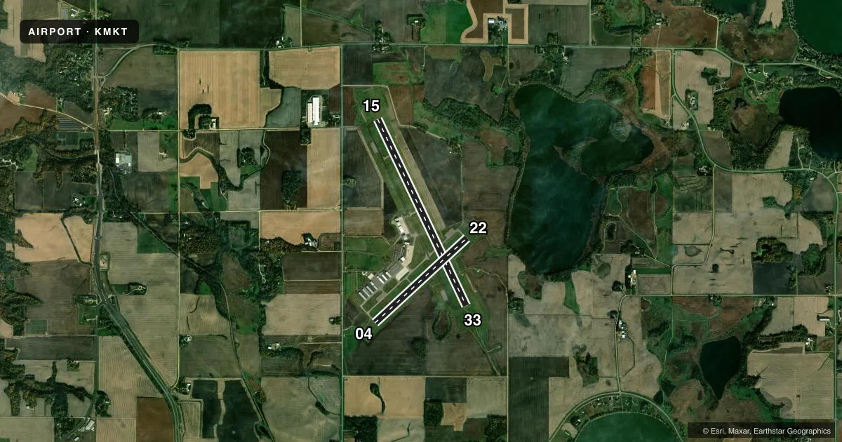
Runways & pattern
Full pagePattern entry · RWY 33
LEFT TRAFFIC| Runway | Heading (°M) | Length | Surface | Traffic |
|---|---|---|---|---|
| 15/33Favored | 155° / 335° | 6,600 ft | CONC | Standard L |
| 04/22 | 47° / 227° | 4,000 ft | ASPH | Standard L |
Runway end performance
| End | TORA | TODA | ASDA | LDA | VGSI | Approach lights | Obstruction |
|---|---|---|---|---|---|---|---|
| 15 | — | — | — | — | PAPI 4-box left(3°) | — | — |
| 33 | — | — | — | — | PAPI 4-box left(3°) | MALSR | — |
| 04 | — | — | — | — | PAPI 4-box left(3°) | — | — |
| 22 | — | — | — | — | PAPI 4-box left(3°) | — | — |
Declared distances in feet. TORA = takeoff run available, TODA = takeoff distance, ASDA = accelerate-stop, LDA = landing distance.
Airport sketch
Runways drawn to scale from FAA survey coordinates, rendered over satellite imagery. Not for navigation.
Approaches & charts
ILS · 1
Services on the field
Fuel grades, oxygen, maintenance, ramp storage and lighting — as declared to the FAA by the airport operator.
Fuel & services
- Fuel
- 100LLA+
- Oxygen (bottled)
- Low pressure
- Oxygen (bulk)
- Not available
- Airframe repair
- Major
- Power plant repair
- Major
- Other services
- AGRI,AVNCS,CHTR,INSTR,PAJA,RNTL,SALES,SURV
Ramp & ground
- Transient storage
- Tie-down
- Hangar
- Landing fee
- No fee published
- Customs
- Not available
- Lighting schedule
- SEE RMK
- Beacon schedule
- SS-SR
- Beacon
- White / Green (civil land)(WG)
- Wind indicator
- Lighted
- Segmented circle
- Yes
Fuel & FBOs
Cheapest 100LL and Jet A on the field and nearby. Always confirm with the FBO before taxi.
Airport notes
Surface conditions, obstructions, local procedures, lighting outages and other notes published with each FAA cycle.
General notes
- DEER & MIGRATORY WATERFOWL ON & INVOF ARPT.
- INTENSIVE FLIGHT TRAINING.
- FBO AVBL ON 123.5.
- FOR CD CTC MINNEAPOLIS ARTCC AT 651-463-5588.
Lighting notes
- ACTIVATE MALSR RWY 33; REIL RWY 04, 15 & 22; PAPI RWY 04, 15, 22 & 33; MIRL RWY 04/22; HIRL RWY 15/33 - CTAF.
Fuel notes
- 100LLAFT HRS CALL 507-469-0228.
- A+AFT HRS CALL 507-469-0228.
Approach & departure obstructions
- 33CALM WIND RWY.
Other notes
- TPA 2000 FT MSL (LT TFC) FOR LIGHT ACFT, 2500 FT MSL (LT TFC) FOR TURBINE ACFT & 2000 FT MSL (RT TFC) FOR ROTORCRAFT ACFT.
VFR map & nearby airports
VFR sectional. Tap any ICAO chip to open that airport.
Key facts · KMKT
Answer card- ICAO
- KMKT
- Name
- MANKATO RGNL
- Location
- MANKATO, MINNESOTA
- Elevation
- 1,020.8 ft MSL
- Traffic pattern altitude
- 2,020.8 ft MSL (1,000 AGL)
- Control tower
- Non-towered (use CTAF)
- Total runways
- 2
- Longest runway
- 15/33 · 6,600 ft
- Published ILS approaches
- 1
- Published frequencies
- 2
- Magnetic variation
- 0°
- Current flight rules
- VFR
- Current wind
- 300° at 10 kt
- Favored runway now
- RWY 33
Mankato Regional Airport sits in Mankato, Minnesota. Field elevation is 1,020.8 ft MSL. The airport has two runways. The longest is 15/33 at 6,600 ft. Runway 04/22 is 4,000 ft. There is no control tower. CTAF and UNICOM are both 122.725.
The published traffic pattern altitude is not standard for all users. Light aircraft use 2,000 ft MSL left traffic. Turbine aircraft use 2,500 ft MSL left traffic. Rotorcraft use 2,000 ft MSL right traffic. Runway 33 is the calm wind runway. There is one ILS approach. It serves runway 33.
North Star Aviation is on the field. It carries 100LL and Jet A. The published remarks also note after-hours fuel contact through the listed number in the Chart Supplement. Expect intensive flight training. Deer and migratory waterfowl are reported on and near the airport, so keep a sharp scan on departure and arrival. Runway lighting is well supported. Runway 33 has medium intensity approach lighting with alignment indicator lights. Runway 15/33 has high intensity runway lights. If you need current clearance delivery details or any operational change, check the current FAA Chart Supplement or call the airport operator or FBO directly.