METAR & TAF KMFD
Current METAR
Observed 21:52Z
KMFD 272152Z 23008KT 10SM CLR 27/20 A2987 RMK AO2 SLP107 T02670200 $
- Wind
- 230° @ 8 kt
- Visibility
- 10 SM
- Temp / Dew
- 27°C / 20°C
- Altimeter
- 29.87 inHg
- Clouds
- CLR
- Density alt
- 3,110 ft
- Ceiling
- Unlimited
- Rules
- VFR
Airport info & contacts
Manager on record, flight service, ARTCC, attendance schedule and pattern altitude — published by the FAA and refreshed every 28 days.
Location
- From city
- 3 NM N
- VFR sectional
- DETROIT
- ARTCC
- ZOB · CLEVELAND
- NOTAM facility
- MFD (NOTAM-D)
Airport manager
- Name
- MARK T DAUGHERTY
- Phone
- 419-522-2191
- Address
- 2000 HARRINGTON MEMORIAL RD, MANSFIELD OH 44903-8051
Flight service · Hours
- FSS CLE
- CLEVELAND1-800-WX-BRIEF
- Attendance
- MON-FRI · 0700-1900
- SAT-SUN · 0800-1800
Frequencies
Tap any row to copy the frequency to your clipboard.
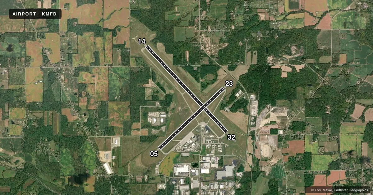
Runways & pattern
Full pagePattern entry · RWY 23
LEFT TRAFFIC| Runway | Heading (°M) | Length | Surface | Traffic |
|---|---|---|---|---|
| 14/32 | 131° / 311° | 9,001 ft | ASPH | Standard L |
| 05/23Favored | 41° / 221° | 6,819 ft | ASPH | Standard L |
Runway end performance
| End | TORA | TODA | ASDA | LDA | VGSI | Approach lights | Obstruction |
|---|---|---|---|---|---|---|---|
| 14 | 9,001' | 9,001' | 9,001' | 9,001' | PAPI 4-box left(3°) | — | 27', road, 1143' from thr, 629' R of cntrln, slope 34 |
| 32 | 9,001' | 9,001' | 9,001' | 9,001' | — | MALSR | 58', trees, 2650' from thr, 250' R of cntrln, slope 42 |
| 05 | 6,819' | 6,819' | 6,819' | 6,819' | PAPI 4-box left(3°) | — | — |
| 23 | 6,819' | 6,819' | 6,819' | 6,819' | PAPI 4-box left(3°) | — | 48', trees, 1550' from thr, 600' R of cntrln, slope 28 |
Declared distances in feet. TORA = takeoff run available, TODA = takeoff distance, ASDA = accelerate-stop, LDA = landing distance.
Airport sketch
Runways drawn to scale from FAA survey coordinates, rendered over satellite imagery. Not for navigation.
Approaches & charts
ILS · 1
Services on the field
Fuel grades, oxygen, maintenance, ramp storage and lighting — as declared to the FAA by the airport operator.
Fuel & services
- Fuel
- 100LLA1+
- Oxygen (bottled)
- High pressure
- Oxygen (bulk)
- Not available
- Airframe repair
- Major
- Power plant repair
- Major
- Other services
- AVNCS,CHTR,INSTR,RNTL,SALES
Ramp & ground
- Transient storage
- Tie-down
- Hangar
- Landing fee
- No fee published
- Customs
- Not available
- Lighting schedule
- SEE RMK
- Beacon schedule
- SS-SR
- Beacon
- White / Green (civil land)(WG)
- Wind indicator
- Lighted
- Segmented circle
- Yes
Fuel & FBOs
Cheapest 100LL and Jet A on the field and nearby. Always confirm with the FBO before taxi.
Airport notes
Surface conditions, obstructions, local procedures, lighting outages and other notes published with each FAA cycle.
General notes
- DEER, BIRDS, & WATERFOWL ON & INVOF ARPT.
- ACFT ON EITHER END OF RWY 05/23 & 14/32 NOT VSB ON THE OTR END DUE TO RWY GRADE.
- ACFT LARGER THAN A 'G1' OR WITH A WING SPAN GREATER THAN 80 FT (TIP TO TIP) ARE RESTRICTED ON TWYS G/H/J/L/M/N & SHOULD USE THE MAIN RAMP AREA.
- 11 FT FENCE, 95 FT FM TWY A CNTRLN BTN AER 05 & TWY F, DOES NOT HAVE RQRD CLNC FM TWY CNTRLN.
- ACFT WITH WINGSPAN GTR THAN 132 FT ARE RESTRICTED TO 15 MPH ON TWY A.
- FOR CD CTC CLEVELAND APCH AT 216-352-2323, WHEN APCH CLSD CTC CLEVELAND ARTCC AT 440-774-0223/0490.
- LGTD & BARRICADED MIL RAMP CLSD TO ALL ACFT.
Lighting notes
- WHEN ATCT CLSD ACTVT MALSR RWY 32; REIL RWY 05 & 23; PAPI RWY 14, 05, & 23; HIRL RWY 05/23 & 14/32 - CTAF.
Runway surface & condition
- 05/23PCR VALUE: 374/F/D/X/T
- 14/32PCR VALUE: 406/F/B/X/T
Other notes
- CLSD TO SKEDD ACR OPS GTR THAN 9 PAX SEATS - CALL AMGR.
- LDG FEES ON ALL COML OPRS INVOICED MONTHLY; FOR OTR ARNGMTS CTC AMGR.
- 1FBO AFT HRS CTC: 419-524-4261 / 419-989-2911.
VFR map & nearby airports
VFR sectional. Tap any ICAO chip to open that airport.
Key facts · KMFD
Answer card- ICAO
- KMFD
- Name
- MANSFIELD LAHM RGNL
- Location
- MANSFIELD, OHIO
- Elevation
- 1,297 ft MSL
- Traffic pattern altitude
- 2,297 ft MSL (1,000 AGL)
- Control tower
- Towered · 0600-2300
- Total runways
- 2
- Longest runway
- 14/32 · 9,001 ft
- Published ILS approaches
- 1
- Published frequencies
- 10
- Magnetic variation
- 6°
- Current flight rules
- VFR
- Current wind
- 230° at 8 kt
- Favored runway now
- RWY 23
Mansfield Lahm Rgnl Airport sits in Mansfield, Ohio at 1,297 ft MSL. It has two asphalt runways. The longest is runway 14/32 at 9,001 ft. Runway 05/23 is 6,819 ft. The airport is towered. Tower hours are 0600 to 2300. It has one ILS approach. It serves runway 32.
Pattern altitude is not published. Use the standard 1,000 ft AGL for light piston traffic unless ATC or the current Chart Supplement says otherwise. Niss Aviation is on the field. It carries 100LL and Jet A. For after-hours FBO contact, the published numbers are 419-524-4261 and 419-989-2911.
A few operational items matter here. Deer, birds and waterfowl are reported on and near the airport. Aircraft on either end of both runways are not visible from the opposite end because of runway grade. Large aircraft also have taxiway limits on parts of the field, so check the current Chart Supplement if you are bringing something bigger than a light piston or a small turboprop. When the tower is closed, published lighting procedures apply on CTAF for runway 32. The airport also has a restriction on scheduled aircraft operations with more than 9 passenger seats. If you need clearance delivery, use Cleveland Approach. If approach is closed, contact Cleveland ARTCC.