METAR & TAF KJAX
Current METAR
Observed 06:56Z
KJAX 280656Z 22006KT 10SM FEW060 BKN250 26/23 A2982 RMK AO2 SLP097 T02610233 $
- Wind
- 220° @ 6 kt
- Visibility
- 10 SM
- Temp / Dew
- 26°C / 23°C
- Altimeter
- 29.82 inHg
- Clouds
- BKN
- Density alt
- 1,481 ft
- Ceiling
- 25,000 ft AGL
- Rules
- VFR
Airport info & contacts
Manager on record, flight service, ARTCC, attendance schedule and pattern altitude — published by the FAA and refreshed every 28 days.
Location
- From city
- 9 NM N
- VFR sectional
- JACKSONVILLE
- ARTCC
- ZJX · JACKSONVILLE
- NOTAM facility
- JAX (NOTAM-D)
Airport manager
- Name
- MR. TERRY DLUGOS
- Phone
- (904) 741-3866
- Address
- 14201 PECAN PARK ROAD, JACKSONVILLE FL 32218
Flight service · Hours
- FSS GNV
- GAINESVILLE1-800-WX-BRIEF
- Attendance
- ALL
Frequencies
Tap any row to copy the frequency to your clipboard.
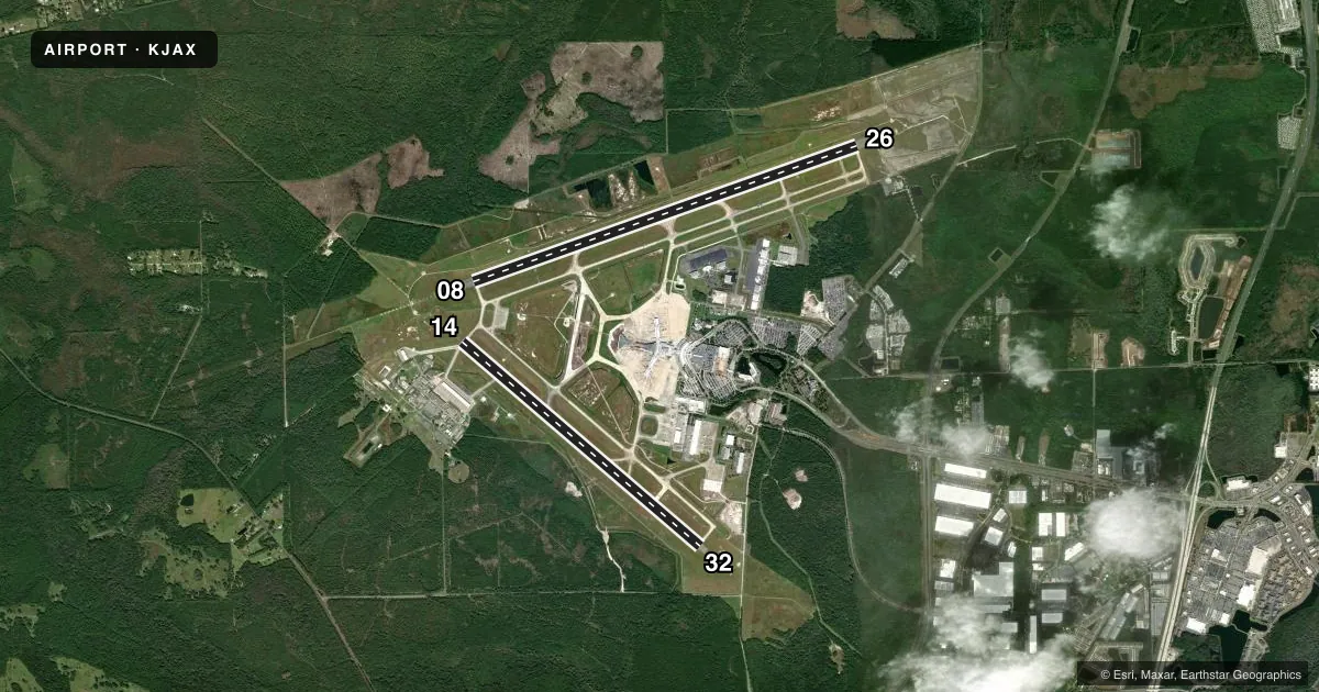
Runways & pattern
Full pagePattern entry · RWY 26
LEFT TRAFFIC| Runway | Heading (°M) | Length | Surface | Traffic |
|---|---|---|---|---|
| 08/26Favored | 65° / 245° | 10,000 ft | CONC | Standard L |
| 14/32 | 125° / 305° | 7,701 ft | CONC | Standard L |
Runway end performance
| End | TORA | TODA | ASDA | LDA | VGSI | Approach lights | Obstruction |
|---|---|---|---|---|---|---|---|
| 08 | — | — | — | — | PAPI 4-box left(3°) | ALSF2 | 63', trees, 3350' from thr, 350' R of cntrln, slope 50 |
| 26 | — | — | — | — | PAPI 4-box right(3°) | MALSR | — |
| 14 | — | — | — | — | PAPI 4-box left(3°) | MALSR | 50', trees, 2735' from thr, 235' R of cntrln, slope 50 |
| 32 | — | — | — | — | PAPI 4-box left(3°) | — | 68', trees, 3290' from thr, 0' R of cntrln, slope 45 |
Declared distances in feet. TORA = takeoff run available, TODA = takeoff distance, ASDA = accelerate-stop, LDA = landing distance.
Airport sketch
Runways drawn to scale from FAA survey coordinates, rendered over satellite imagery. Not for navigation.
Approaches & charts
ILS · 3
Services on the field
Fuel grades, oxygen, maintenance, ramp storage and lighting — as declared to the FAA by the airport operator.
Fuel & services
- Fuel
- 100LLA
- Airframe repair
- Major
- Power plant repair
- Minor
- Other services
- AFRT,AVNCS,CARGO,CHTR,SURV
Ramp & ground
- Transient storage
- Tie-down
- Hangar
- Landing fee
- No fee published
- Customs
- Not available
- Lighting schedule
- SS-SR
- Beacon schedule
- SS-SR
- Beacon
- White / Green (civil land)(WG)
- Wind indicator
- Lighted
- Segmented circle
- Yes
Fuel & FBOs
Cheapest 100LL and Jet A on the field and nearby. Always confirm with the FBO before taxi.
Airport notes
Surface conditions, obstructions, local procedures, lighting outages and other notes published with each FAA cycle.
General notes
- BIRD ACTIVITY INVOF ARPT, WILDLIFE PRESENTLY ON AIRFIELD.
- BAK-14 CABLE RAISED FOR TAILHOOK ENGAGEMENT BY TWR ON PILOT REQ ONLY, 1537 FT FM AER 08 AND 1612 FT FM AER 26.
- ARPT CLSD TO INTL GEN AVIATION ARR EXE 6HR PPR ARPT OPS AT 904-741-2020 & CTC U. S. CUSTOMS & SERVICING FBO FOR PROCESSING & INSTRUCTIONS.
- RADIO CONTROLLED ACFT ACTIVITY 3.5 NM 'NNW' OF ARPT.
- SMALL PORTION OF TERMINAL RAMP NOT VISIBLE FM TWR. TWR UNABLE TO DETERMINE IF RAMP IS CLEAR.
- NON-LOAD BEARING ASPHALT ON WEST AIR CARRIER RAMP BTWN OUTER HIGH MAST LIGHTS AND TERMINAL. AIRCRAFT RQRD TO MAINTAIN TAXI OPS OVER CTRLN ON THE AIR CARRIER RAMP.
- PPR FOR HIGH POWER JET ENGINE RUN UPS CTC APT OPS AT 904-741-2020.
- MILITARY: ANG: OPR DAYS VARY. BASE OPS 1130-2100Z++. OFFL BUS ONLY. PPR FOR ALL TRAN AFCT (CALL FANG OPS) DSN 641-7122/40/25,C 904-741-7122/40/25. PPR NEEDED TO PROCD ON TWY M1, M2, M3 FANG MAIN RAMP AND ALERT RAMP. PPR NO RESTRD TO ONLY 1 HR EARLIER OR LTR THAN APVL TIME, BFR/AFT THOSE TIMES THE NO IS NOT VALID. TRAN SVCS UNAVBL. FOR CURRENT BWC CTC SOF (FANG OPS) 251.25. BASH PHASE II 1 NOV THRU 31 MAR FOR MIGRATORY BIRD ACT. FOR MORE DTLD INFO SEE AP/1.
- ARPT CLSD TO ACFT WINGSPAN MORE THAN 171 FT EXC 6 HR PPR 904-741-2020.
- 24 HR PPR FOR ACFT EQUIPPED WITH WEATHER MODIFICATION OR GEOENGINEERING EQPT 904-741-2020.
- PILOTS CONDUCTING EFVS OPS; BE AWARE LED ALS IN USE RWY 14.
Runway surface & condition
- 08/26PCR VALUE: 970/R/A/W/T
- 14/32PCR VALUE: 1380/R/B/W/T
Arresting gear
- 08_BAK-14BAK-14 BAK-12B(B) (1537 FT).
- 26_BAK-14BAK-14 BAK-12B-(B) (1612 FT)
Other notes
- PPR 24 HRS FOR UNSKED ACR OPNS WITH MORE THAN 30 PSGR SEATS CALL AMGR 904-741-2020.
VFR map & nearby airports
VFR sectional. Tap any ICAO chip to open that airport.
Key facts · KJAX
Answer card- ICAO
- KJAX
- Name
- JACKSONVILLE INTL
- Location
- JACKSONVILLE, FLORIDA
- Elevation
- 29.6 ft MSL
- Traffic pattern altitude
- 1,029.6 ft MSL (1,000 AGL)
- Control tower
- Towered · 24
- Total runways
- 2
- Longest runway
- 08/26 · 10,000 ft
- Published ILS approaches
- 3
- Published frequencies
- 32
- Magnetic variation
- 6°
- Current flight rules
- VFR
- Current wind
- 220° at 6 kt
- Favored runway now
- RWY 26
Jacksonville Intl is in Jacksonville, Florida. Field elevation is 29.6 ft MSL. The airport has two runways. The longest is 10,000 ft on 08/26. The tower is open 24 hours. Three ILS approaches are published, with runway ends 08, 14 and 26 served. Pattern altitude is not published in the facts, so use the standard 1,000 ft AGL for light piston traffic unless the current Chart Supplement says otherwise.
Sheltair is on the field. It carries 100LL, Jet A and Jet A Prist. Signature Aviation is also on the field. It carries 100LL and Jet A. For a first-time arrival, pay close attention to the airport’s busy traffic flow. The mix includes airline, military and general aviation operations. The tower notes that a small part of the terminal ramp is not visible from the cab. Do not assume ramp clearance without a positive signal. Bird activity is also reported on the field. Expect wildlife awareness to matter on taxi and departure.
There are a few operational items to plan around. International general aviation arrivals are closed unless prior permission is obtained. Military Air National Guard activity also has specific prior permission rules. Check the current Chart Supplement and coordinate with the airport operator or the FBO directly by phone before arrival if your flight involves anything outside normal domestic GA operations.