METAR & TAF KIMT
Current METAR
Observed 17:54Z
KIMT 271754Z AUTO 14007G15KT 10SM CLR 27/20 A2965 RMK AO2 SLP031 60006 T02720200 10272 20206 56044
- Wind
- 140° @ 7G15 kt
- Visibility
- 10 SM
- Temp / Dew
- 27°C / 20°C
- Altimeter
- 29.65 inHg
- Clouds
- CLR
- Density alt
- 3,240 ft
- Ceiling
- Unlimited
- Rules
- VFR
Airport info & contacts
Manager on record, flight service, ARTCC, attendance schedule and pattern altitude — published by the FAA and refreshed every 28 days.
Location
- From city
- 2 NM W
- VFR sectional
- GREEN BAY
- Pattern altitude
- 800 ft AGL · 1,982 ft MSL
- ARTCC
- ZMP · MINNEAPOLIS
- NOTAM facility
- IMT (NOTAM-D)
Airport manager
- Name
- TIM HOWEN
- Phone
- 906-774-4870
- Address
- FORD ARPT, KINGSFORD MI 49801
Flight service · Hours
- FSS GRB
- GREEN BAY1-800-WX-BRIEF
- Attendance
- 0600-2100
Frequencies
Tap any row to copy the frequency to your clipboard.
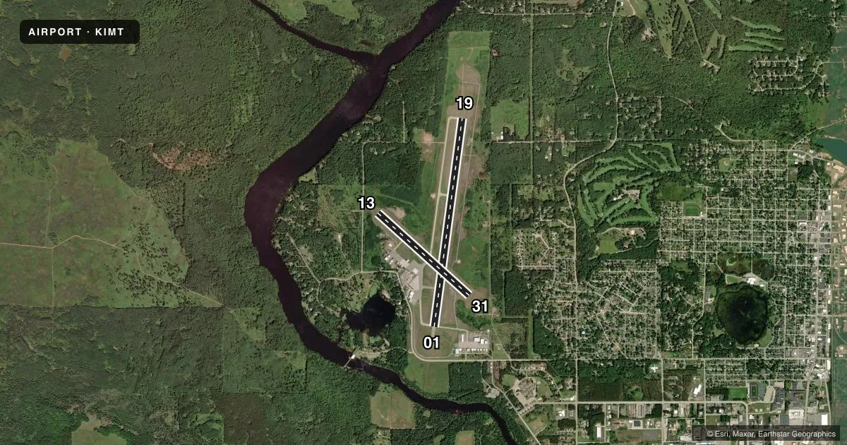
Runways & pattern
Full pagePattern entry · RWY 13
LEFT TRAFFIC| Runway | Heading (°M) | Length | Surface | Traffic |
|---|---|---|---|---|
| 01/19 | 6° / 186° | 6,502 ft | ASPH | Standard L |
| 13/31Favored | 130° / 310° | 3,810 ft | ASPH | Standard L |
Runway end performance
| End | TORA | TODA | ASDA | LDA | VGSI | Approach lights | Obstruction |
|---|---|---|---|---|---|---|---|
| 01 | 6,502' | 6,502' | 6,502' | 6,502' | — | MALSR | — |
| 19 | 6,502' | 6,502' | 6,376' | 6,376' | PAPI 4-box left(3°) | — | — |
| 13 | 3,810' | 3,810' | 3,810' | 3,810' | — | — | — |
| 31 | 3,810' | 3,810' | 3,810' | 3,810' | PAPI 4-box left(4°) | — | — |
Declared distances in feet. TORA = takeoff run available, TODA = takeoff distance, ASDA = accelerate-stop, LDA = landing distance.
Airport sketch
Runways drawn to scale from FAA survey coordinates, rendered over satellite imagery. Not for navigation.
Approaches & charts
ILS · 1
Services on the field
Fuel grades, oxygen, maintenance, ramp storage and lighting — as declared to the FAA by the airport operator.
Fuel & services
- Fuel
- 100LLA
- Oxygen (bottled)
- Low pressure
- Oxygen (bulk)
- Not available
- Airframe repair
- Major
- Power plant repair
- Major
- Other services
- AFRT,CHTR,INSTR,RNTL
Ramp & ground
- Transient storage
- Tie-down
- Hangar
- Landing fee
- Yes
- Customs
- Not available
- Lighting schedule
- SEE RMK
- Beacon schedule
- SS-SR
- Beacon
- White / Green (civil land)(WG)
- Wind indicator
- Lighted
- Segmented circle
- No
Fuel & FBOs
Cheapest 100LL and Jet A on the field and nearby. Always confirm with the FBO before taxi.
Airport notes
Surface conditions, obstructions, local procedures, lighting outages and other notes published with each FAA cycle.
General notes
- DEER, COYOTES, & BIRDS ON & INVOF ARPT.
- 48 HRS PPR FOR UNSKED ACR OPS GTR THAN 30 PAX SEATS - CALL AMGR CELL.
- ARFF CREWS MNT CTAF/UNICOM DRG ALL ACR OPS.
- SNOW REMOVAL CREWS MNT CTAF/UNICOM DRG ALL ACR OPS TO PRVD SFC COND RPRTS.
- FLD CONDS UNMON OCT 15 THRU APR 1 BTN 2100-0600.
Lighting notes
- ACTVT MALSR RWY 01; REIL RWY 19 & 31; PAPI RWY 19 & 31; HIRL RWY 01/19; MIRL RWY 13/31 - CTAF.
Runway surface & condition
- 01/19PCR VALUE: 159/F/B/X/T
- 13/31PCR VALUE: 99/F/B/X/T
- 13/31RWY 13/31 NOT AVBL FOR PART 121/PART 380 OPS WITH SKED PAX CARRYING OPS MORE THAN 9 PAX SEATS AND NON-SKED PAX CARRYING OPS MORE THAN 30 PAX SEATS.
Other notes
- ACR OPS GTR THAN 9 PAX SEATS NA IF NOT WI 15 MINS OF SKEDD ARR/DEP TIME EXC BY PRIOR CDN WITH AMGR & CFMN ARFF IS AVBL PRIOR TO TKOF/LDG.
- TPA FOR JET/TURBO-JET AND PROP ACFT OVER 12500LBS IS 1500' AGL.
- UNICOM IREG MNTD.
- MANAGERCELL 906-201-1866.
VFR map & nearby airports
VFR sectional. Tap any ICAO chip to open that airport.
Key facts · KIMT
Answer card- ICAO
- KIMT
- Name
- FORD
- Location
- IRON MOUNTAIN KINGSFORD, MICHIGAN
- Elevation
- 1,182 ft MSL
- Traffic pattern altitude
- 1,982 ft MSL (800 AGL)
- Control tower
- Non-towered (use CTAF)
- Total runways
- 2
- Longest runway
- 01/19 · 6,502 ft
- Published ILS approaches
- 1
- Published frequencies
- 2
- Magnetic variation
- 2°
- Current flight rules
- VFR
- Current wind
- 140° at 7 kt
- Favored runway now
- RWY 13
Ford Airport sits in Iron Mountain Kingsford, Michigan. The field elevation is 1,182 ft MSL. It has two asphalt runways. The longest is runway 01/19 at 6,502 ft. There is no control tower. CTAF and UNICOM are both 122.8. The airport has one ILS approach to runway 01. The published pattern altitude is 800 ft AGL, which is 1,982 ft MSL.
Kubick Aviation Services is on the field. It carries 100LL and Jet A Prist. Call (906) 779-5500 for current service details. The published remarks also note that runway 01 has medium intensity approach lighting with runway alignment indicators. Runways 19 and 31 have runway end identifier lights. Precision approach path indicators are available on runways 19 and 31. High intensity runway lights are on runways 01 and 19. Medium intensity runway lights are on runways 13 and 31.
For a first-time arrival, watch the pattern setup and the runway lighting setup. Deer, coyotes and birds are reported on and near the airport. Snow removal crews monitor CTAF and UNICOM during aircraft operations for surface condition reports. UNICOM is irregularly monitored. Do not rely on it as your only source. If you are planning a larger aircraft operation, check the published restrictions in the current FAA Chart Supplement and coordinate with the airport manager before you go.