METAR & TAF KGLH
Current METAR
Observed 18:53Z
KGLH 271853Z 29006KT 10SM CLR 36/22 A2990 RMK AO2 SLP129 T03610217
- Wind
- 290° @ 6 kt
- Visibility
- 10 SM
- Temp / Dew
- 36°C / 22°C
- Altimeter
- 29.90 inHg
- Clouds
- CLR
- Density alt
- 2,707 ft
- Ceiling
- Unlimited
- Rules
- VFR
Airport info & contacts
Manager on record, flight service, ARTCC, attendance schedule and pattern altitude — published by the FAA and refreshed every 28 days.
Location
- From city
- 5 NM NE
- VFR sectional
- MEMPHIS
- ARTCC
- ZME · MEMPHIS
- NOTAM facility
- GLH (NOTAM-D)
Airport manager
- Name
- LEVELL D. HAWKINS
- Phone
- 662-334-3121
- Address
- 166 FIFTH AVE STE 300, GREENVILLE MS 38703
Flight service · Hours
- FSS GWO
- GREENWOOD1-800-WX-BRIEF
- Attendance
- 0700-1700
Frequencies
Tap any row to copy the frequency to your clipboard.
Runways & pattern
Full pagePattern entry · RWY 36R
RIGHT TRAFFIC| Runway | Heading (°M) | Length | Surface | Traffic |
|---|---|---|---|---|
| 18L/36RFavored | 179° / 359° | 8,001 ft | ASPH | 36R R |
| 18R/36L | 179° / 359° | 7,019 ft | ASPH-CONC | 18R R |
Runway end performance
| End | TORA | TODA | ASDA | LDA | VGSI | Approach lights | Obstruction |
|---|---|---|---|---|---|---|---|
| 18L | 8,001' | 8,001' | 7,981' | 7,981' | — | MALSR | — |
| 36R | 8,001' | 8,001' | 8,001' | 8,001' | PAPI 4-box left(3°) | — | 84', tree, 3691' from thr, 478' R of cntrln, slope 41 |
| 18R | — | — | — | — | PAPI 4-box left(3°) | — | — |
| 36L | — | — | — | — | PAPI 4-box left(3°) | — | 56', trees, 1400' from thr, 425' R of cntrln, slope 21 |
Declared distances in feet. TORA = takeoff run available, TODA = takeoff distance, ASDA = accelerate-stop, LDA = landing distance.
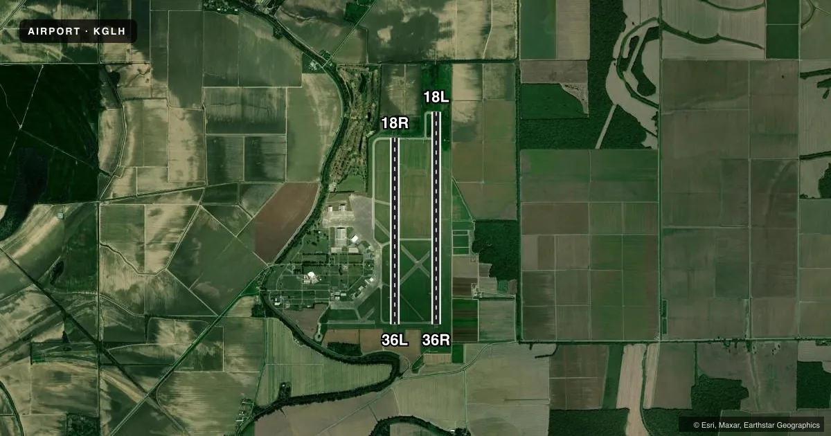
Airport sketch
Runways drawn to scale from FAA survey coordinates, rendered over satellite imagery. Not for navigation.
Approaches & charts
ILS · 1
Services on the field
Fuel grades, oxygen, maintenance, ramp storage and lighting — as declared to the FAA by the airport operator.
Fuel & services
- Fuel
- 100LLA
- Oxygen (bottled)
- Not available
- Oxygen (bulk)
- Not available
- Airframe repair
- Not available
- Power plant repair
- Not available
- Other services
- AGRI,CARGO
Ramp & ground
- Transient storage
- Tie-down
- Hangar
- Landing fee
- No fee published
- Customs
- Not available
- Lighting schedule
- SEE RMK
- Beacon schedule
- SS-SR
- Beacon
- White / Green (civil land)(WG)
- Wind indicator
- Lighted
- Segmented circle
- Yes
Fuel & FBOs
Cheapest 100LL and Jet A on the field and nearby. Always confirm with the FBO before taxi.
Airport notes
Surface conditions, obstructions, local procedures, lighting outages and other notes published with each FAA cycle.
General notes
- TWYS C & D ARE CLSD, TWY F NOT AVBL FOR ACR USE.
- FOR CD WHEN ATCT CLSD, CTC MEMPHIS ARTCC AT 901-368-8453/8449.
- CLSD TO SKED ACR OPS WITH MORE THAN 9 PAX SEATS & UNSKED ACR OPS WITH MORE THAN 30 PAX SEATS.
- SGFNT BIRD ACT INVOF RWYS.
- FUEL AVBL 7AM-5PM DLY, AFT HRS CALL 662-822-5269.
Lighting notes
- WHEN ATCT CLSD ACTVT OR INCR INTST MALSR RWY 18L; MIRL RWY 18R/36L; HIRL RWY 18L/36R - CTAF. PAPI RWY 18R, 36L, & 36R OPR CONSLY; HIRL RWY 18L/36R PRESET MED INTST.
Runway surface & condition
- 18R/36LNO TKOF OR LNDG AUTH FOR ACR ACFT.
Approach & departure obstructions
- 18RMARKINGS FADED.
- 36LMARKINGS FADED.
Other notes
- 18R/36LUNEVEN PAVEMENT.
VFR map & nearby airports
VFR sectional. Tap any ICAO chip to open that airport.
Key facts · KGLH
Answer card- ICAO
- KGLH
- Name
- GREENVILLE MID-DELTA
- Location
- GREENVILLE, MISSISSIPPI
- Elevation
- 130.7 ft MSL
- Traffic pattern altitude
- 1,130.7 ft MSL (1,000 AGL)
- Control tower
- Towered · 0700-1900
- Total runways
- 2
- Longest runway
- 18L/36R · 8,001 ft
- Published ILS approaches
- 1
- Published frequencies
- 8
- Magnetic variation
- 1°
- Current flight rules
- VFR
- Current wind
- 290° at 6 kt
- Favored runway now
- RWY 36R
Greenville Mid-Delta Airport sits in Greenville, Mississippi. The field elevation is 130.7 ft MSL. It has two runways. The longest is 18L/36R at 8,001 ft. The other runway is 18R/36L at 7,019 ft. The airport has a control tower. Published tower hours are 0700 to 1900. One ILS approach is published for runway 18L.
Pattern altitude is not published in the facts. Use the current FAA Chart Supplement before you fly. Mid-Delta Aviation is the on-field FBO. It carries 100LL and Jet A. Fuel is listed as available daily from 7 AM to 5 PM. After hours, call the number in the Chart Supplement or the FBO directly.
A few operational items matter here. Runway 18R/36L has uneven pavement. Markings on 18R and 36L are faded. Significant bird activity is reported near the runways. Taxiways C and D are closed. Taxiway F is not available for air carrier use. When the tower is closed, use the CTAF for lighting activation. The published remarks also note that runway 18L/36R has high intensity lights that are preset to medium intensity. This is a busy field with a long main runway. Plan ahead for the tower window, lighting and runway condition before you arrive.