METAR & TAF KFOK
Current METAR
Observed 17:53Z
KFOK 271753Z 17008KT 10SM CLR 26/19 A2985 RMK AO2 LTG DSNT W SLP106 T02560194 10261 20222 58006
- Wind
- 170° @ 8 kt
- Visibility
- 10 SM
- Temp / Dew
- 26°C / 19°C
- Altimeter
- 29.85 inHg
- Clouds
- CLR
- Density alt
- 1,489 ft
- Ceiling
- Unlimited
- Rules
- VFR
Airport info & contacts
Manager on record, flight service, ARTCC, attendance schedule and pattern altitude — published by the FAA and refreshed every 28 days.
Location
- From city
- 3 NM N
- VFR sectional
- NEW YORK
- ARTCC
- ZNY · NEW YORK
- NOTAM facility
- FOK (NOTAM-D)
Airport manager
- Name
- JOSHUA SMITH
- Phone
- 631-852-8095
- Address
- GABRESKI AIRPORT, ADMINISTRATION BLDG #1, WESTHAMPTON NY 11978
Flight service · Hours
- FSS ISP
- NEW YORK1-800-WX-BRIEF
- Attendance
- 0700-2300
Frequencies
Tap any row to copy the frequency to your clipboard.
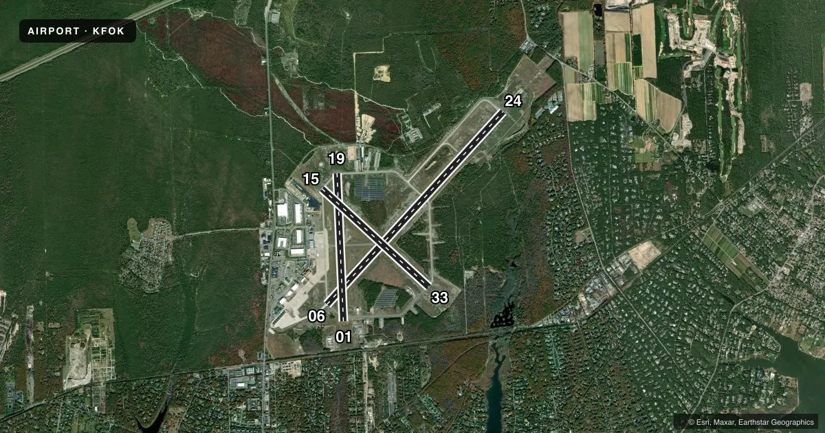
Runways & pattern
Full pagePattern entry · RWY 19
LEFT TRAFFIC| Runway | Heading (°M) | Length | Surface | Traffic |
|---|---|---|---|---|
| 06/24 | 30° / 210° | 9,002 ft | ASPH-CONC | 24 R |
| 01/19Favored | 344° / 164° | 5,100 ft | ASPH-CONC | Standard L |
| 15/33 | 119° / 300° | 5,002 ft | ASPH | 33 R |
Runway end performance
| End | TORA | TODA | ASDA | LDA | VGSI | Approach lights | Obstruction |
|---|---|---|---|---|---|---|---|
| 06 | — | — | — | — | PAPI 2-box left(3°) | — | 85', trees, 1776' from thr, 278' R of cntrln, slope 18 |
| 24 | — | — | — | — | PAPI 4-box left(3°) | MALSR | 70', trees, 1086' from thr, 620' R of cntrln, slope 12 |
| 01 | — | — | — | — | — | — | 55', trees, 1342' from thr, 219' R of cntrln, slope 20 |
| 19 | — | — | — | — | — | — | 49', trees, 1014' from thr, 329' R of cntrln, slope 16 |
| 15 | — | — | — | — | PAPI 2-box left(3°) | — | 58', trees, 1067' from thr, 153' R of cntrln, slope 14 |
| 33 | — | — | — | — | VASI 4-box left(3°) | — | 42', trees, 1070' from thr, 250' R of cntrln, slope 20 |
Declared distances in feet. TORA = takeoff run available, TODA = takeoff distance, ASDA = accelerate-stop, LDA = landing distance.
Airport sketch
Runways drawn to scale from FAA survey coordinates, rendered over satellite imagery. Not for navigation.
Approaches & charts
ILS · 1
Services on the field
Fuel grades, oxygen, maintenance, ramp storage and lighting — as declared to the FAA by the airport operator.
Fuel & services
- Fuel
- 100LLA
- Oxygen (bottled)
- HIGH/LOW
- Oxygen (bulk)
- Not available
- Airframe repair
- Major
- Power plant repair
- Major
- Other services
- AVNCS,CHTR,SALES
Ramp & ground
- Transient storage
- Tie-down
- Hangar
- Landing fee
- Yes
- Customs
- Not available
- Lighting schedule
- SEE RMK
- Beacon schedule
- SS-SR
- Beacon
- White / Green (civil land)(WG)
- Wind indicator
- Yes
- Segmented circle
- No
Fuel & FBOs
Cheapest 100LL and Jet A on the field and nearby. Always confirm with the FBO before taxi.
Airport notes
Surface conditions, obstructions, local procedures, lighting outages and other notes published with each FAA cycle.
General notes
- BEARING STRENGTH RWY 01-19: S38 T49
- BEARING STENGTH RWY 06-24: S100 DW120 DT 200.
- BEARING STENGTH RWY 15-33: S94 DW157 DT259.
- JASU: AVBL DUR ANG OPR HR. (A/M32A-86) 2(MA-1A).
- FUEL: AVBL DUR ANG OPR HR. J8(MIL) (NC-100LL, A).
- FLUID - SP DE-ICE LOX.
- OIL - O-148-156(MIL) SOAP.
- RSTD - NO 180 DEG TURNS PMTD ON ASPH SECTION OF RWY 06/24.
- CAUTION: BIRDS AND DEER HAZ. PJE VCNTY OF ARPT.
- CSTMS/AG/IMG: US CSTMS CLNC SVC AVBL WITH PN (FRG) 631-753-2691 (MIL FLTS WILL COORD THRU BASE OPNS 631-723-7362/7364). MIN 24 HR PN ON RGLR BUS DAY PRECDNG SVC RQR DATE, MAX PAX 15. US CSTMS HRS BTN 0800 AND 2200 LOCAL.
- CLASS D AIRSPACE EFF 1200-0400Z++; OT CLASS G.
- MILITARY: ANG: PPR OFFL BUS. FOR USE OF ANG RAMP. OFFL BUS ONLY PPR ALL ACFT, 48 HR PN, CTC AFLD OPS DSN 456-7362, C631-723-7362 DRG DUTY HR. TUE-FRI PPR DRG OFF-DUTY HR. 106 OG/CC APVL REQUIRED NML DUTY HR. NML DUTY HR 1200-2130++ MON-FRI. CLSD SAT, SUN, HOL AND EV OTR MON. LTD RAMP SPACE. TRAN ACFT MAY BE DIVERTED TO CIV FBO DRG NON-DUTY HR. NON-STANDARD MARKINGS ON HH-60 APRON; WHITE PAINTED LINES DENOTING A ROADWAY ON THE APRON BY THE PODS INDICATING WHERE A VEHICLE MUST DRIVE IN ORDER TO MAINTAIN ALL NECESSARY WINGTIP CLEARANCES.
- VOLUNTARY NOISE ABATEMENT PROCS IN EFCT; SEE ARPT WEBSITE.
- ANG: ADVSY FOR TRAN AIRCREWS - WING TIP CLNC WAIVER IN EFFECT ON GUARD C-130 RAMP.
- FUEL: A++ (MIL) AVBL.
- FOR CD WHEN ATCT CLSD CTC NEW YORK APCH AT 516-683-2449.
- RCMDD RSVN WITH FBO PRIOR TO ARR.
- WHEN SAFETY AND OPNS ALLOW, RWY 24 PREF FOR NOISE ABATEMENT.
Lighting notes
- WHEN ATCT CLSD ACTVT MALSR RWY 24; REIL RWY 06, 15, & 33; PAPI RWY 06, 15 & 24; VASI RWY 33; HIRL RWY 06/24; MIRL RWY 15/33 - CTAF.
Runway surface & condition
- 01/19SOUTH END RWY 900 FT & NORTH END RWY 1000 FT ARE SAFETY AREAS.
- 06/24RWY 06/24 1000 FT SAFETY AREA EACH END.
- 15/33RWY 15/33 1000 FT SAFETY AREA EACH END.
Approach & departure obstructions
- 06+30 FT TREES, 135-285 FT FM RWY END, 357-530 FT RIGHT; +50 FT STRUCTURE, 1500 FT FM RWY, 78 FT RIGHT.
- 1515/33 MIL MAX EFFORT LDG STRIP MKGS (3500 X 60) INCLD WITH NPI RWY MKGS.
- 01+40 FT TO 55 FT TREES, 1280 FT TO 1360 FT FM RWY, PERPENDICULAR TO EXTDD RWY CNTRLN.
- 15+35 FT TO 52 FT TREES, 1112 FT TO 1141 FT FM RWY, PERPENDICULAR TO EXTDD RWY CNTRLN.
- 19+33 FT TO 47 FT TREES, 1000 FT TO 1080 FT FM RWY, PERPENDICULAR TO EXTDD RWY CNTRLN.
- 24+85 FT TO 91 FT TREES, 2160 FT TO 2350 FT FM RWY, PERPENDICULAR TO EXTDD RWY CNTRLN.
- 33+30 FT TO 33 FT TREES, 1035 FT TO 1103 FT FM RWY, PERPENDICULAR TO EXTDD RWY CNTRLN.
Other notes
- EXISTED PRIOR TO 1959. CHANGE TO CIVIL OPN.
- 06/246000 FT ASPH OVERLAY IN CNTR OF RWY.
VFR map & nearby airports
VFR sectional. Tap any ICAO chip to open that airport.
Key facts · KFOK
Answer card- ICAO
- KFOK
- Name
- FRANCIS S GABRESKI
- Location
- WESTHAMPTON BEACH, NEW YORK
- Elevation
- 66.1 ft MSL
- Traffic pattern altitude
- 1,066.1 ft MSL (1,000 AGL)
- Control tower
- Towered · 0700-2300
- Total runways
- 3
- Longest runway
- 06/24 · 9,002 ft
- Published ILS approaches
- 1
- Published frequencies
- 8
- Magnetic variation
- 13°
- Current flight rules
- VFR
- Current wind
- 170° at 8 kt
- Favored runway now
- RWY 19
Francis S Gabreski is in Westhampton Beach, New York. Field elevation is 66.1 ft MSL. The airport has three runways. The longest is 9,002 ft on 06/24. The tower is open 0700-2300 local. Outside those hours, the field uses CTAF 125.3. There is one ILS approach. It serves runway 24.
Pattern altitude is not published. Use 1,000 ft AGL for light piston traffic unless the current Chart Supplement says otherwise. That puts the normal pattern at about 1,066 ft MSL based on the field elevation. The airport sits in Class D airspace from 1200 to 0400 Zulu. Other times it is Class G. That matters for arrival planning, especially if you are coming in after tower hours.
Signature Aviation is on the field. It carries AVGAS 100LL and Jet A. Modern Aviation is also on the field. It carries AVGAS 100LL, Jet A and Jet A Prist. Published remarks call out birds and deer in the area. There are also trees near the extended centerlines for 15 and 24. The airport has customs service with prior notice for foreign flights. If you are planning an international arrival, call ahead and confirm the current process with the airport operator or the FBO directly by phone.