METAR & TAF KENW
Current METAR
Observed 18:01Z
KENW 271801Z 13012G24KT 10SM BKN006 OVC015 22/22 A2975 RMK AO2 LTG DSNT NE-S RAE00 P0000 T02220217
- Wind
- 130° @ 12G24 kt
- Visibility
- 10 SM
- Temp / Dew
- 22°C / 22°C
- Altimeter
- 29.75 inHg
- Clouds
- OVC
- Density alt
- 1,972 ft
- Ceiling
- 600 ft AGL
- Rules
- IFR
Airport info & contacts
Manager on record, flight service, ARTCC, attendance schedule and pattern altitude — published by the FAA and refreshed every 28 days.
Location
- From city
- 4 NM W
- VFR sectional
- CHICAGO
- ARTCC
- ZAU · CHICAGO
- NOTAM facility
- ENW (NOTAM-D)
Airport manager
- Name
- COREY REED
- Phone
- 262-653-4161
- Address
- 9900 52ND ST, KENOSHA WI 53144
Flight service · Hours
- FSS GRB
- GREEN BAY1-800-WX-BRIEF
- Attendance
- 0700-2100
Frequencies
Tap any row to copy the frequency to your clipboard.
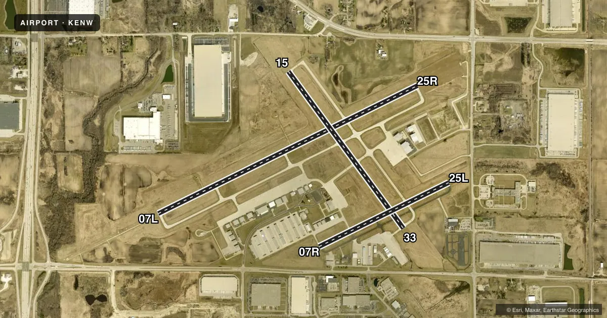
Runways & pattern
Full pagePattern entry · RWY 15
LEFT TRAFFIC| Runway | Heading (°M) | Length | Surface | Traffic |
|---|---|---|---|---|
| 07L/25R | 62° / 242° | 6,600 ft | CONC | 25R R |
| 15/33Favored | 142° / 322° | 4,440 ft | ASPH | Standard L |
| 07R/25L | 62° / 242° | 3,302 ft | ASPH | 07R R |
Runway end performance
| End | TORA | TODA | ASDA | LDA | VGSI | Approach lights | Obstruction |
|---|---|---|---|---|---|---|---|
| 07L | — | — | — | — | PAPI 4-box left(3°) | MALSR | — |
| 25R | — | — | — | — | PAPI 4-box left(3°) | — | — |
| 15 | — | — | — | — | VASI 4-box left(4°) | — | 58', trees, 1150' from thr, 270' R of cntrln, slope 16 |
| 33 | — | — | — | — | VASI 4-box left(3°) | — | — |
| 07R | — | — | — | — | PAPI 4-box left(3°) | — | — |
| 25L | — | — | — | — | PAPI 4-box left(3°) | — | 34', trees, 850' from thr, 25' R of cntrln, slope 19 |
Declared distances in feet. TORA = takeoff run available, TODA = takeoff distance, ASDA = accelerate-stop, LDA = landing distance.
Airport sketch
Runways drawn to scale from FAA survey coordinates, rendered over satellite imagery. Not for navigation.
Approaches & charts
ILS · 1
Services on the field
Fuel grades, oxygen, maintenance, ramp storage and lighting — as declared to the FAA by the airport operator.
Fuel & services
- Fuel
- 100LLA+
- Oxygen (bottled)
- Not available
- Oxygen (bulk)
- HIGH/LOW
- Airframe repair
- Major
- Power plant repair
- Major
- Other services
- AVNCS,CARGO,CHTR,INSTR,RNTL,SALES
Ramp & ground
- Transient storage
- Tie-down
- Hangar
- Landing fee
- No fee published
- Customs
- Not available
- Lighting schedule
- SEE RMK
- Beacon schedule
- SS-SR
- Beacon
- White / Green (civil land)(WG)
- Wind indicator
- Yes
- Segmented circle
- Yes
Fuel & FBOs
Cheapest 100LL and Jet A on the field and nearby. Always confirm with the FBO before taxi.
Airport notes
Surface conditions, obstructions, local procedures, lighting outages and other notes published with each FAA cycle.
General notes
- BIRDS ON & INVOF ARPT.
- HELICOPTER DEP & ARR OPS WILL BE AUTH BY ATC FM MOVEMENT AREAS ONLY. NON-MOVEMENT AREA DEPS, ARRS & PRACTICE, ARE PROHIBITED.
- ACFT WEIGHING MORE THAN 122,000 LBS, EMPTY OR FULLY LOADED, ARE NOT ALLOWED TO BE BASED AT KENW. THE TERM BASED SHALL BE DEFINED AS AN ACFT THAT IS OPR & AIRWORTHY ON THE ARPT FOR A MAJORITY OF THE YEAR.
- SFC INCIDENT RISK. TWY D AND TWY E. INTXN NOT VSB FM TWR..
Lighting notes
- WHEN ATCT CLSD, HIRL RWY 07L/25R PRESET ON LOW INTST; TO INCR INTST & ACTVT MALSR RWY 07L; REIL RWY 15, 25R & 33; PAPI RWY 07L, 07R, 25L & 25R; HIRL RWY 07L/25R & 15/33; MIRL RWY 07R/25L - CTAF. VASI RWY 15 & 33 OPRS CONSLY.
Runway surface & condition
- 07L/25RPCR VALUE: 430/R/D/W/T
- 07R/25LCLSD TO JET ACFT & ACFT WEIGHING MORE THAN 12500 LBS WHEN RWY 07L/25R IS OPEN.
Approach & departure obstructions
- 25LPAPI UNUSBL BYD 7 DEGS RIGHT OF CNTRLN.
VFR map & nearby airports
VFR sectional. Tap any ICAO chip to open that airport.
Key facts · KENW
Answer card- ICAO
- KENW
- Name
- KENOSHA RGNL
- Location
- KENOSHA, WISCONSIN
- Elevation
- 742.6 ft MSL
- Traffic pattern altitude
- 1,742.6 ft MSL (1,000 AGL)
- Control tower
- Towered · 0700-2100
- Total runways
- 3
- Longest runway
- 07L/25R · 6,600 ft
- Published ILS approaches
- 1
- Published frequencies
- 10
- Magnetic variation
- 2°
- Current flight rules
- IFR
- Current wind
- 130° at 12 kt
- Favored runway now
- RWY 15
Kenosha Regional sits in Kenosha, Wisconsin. The field elevation is 742.6 ft MSL. It has three runways. The longest is 07L/25R at 6,600 ft. The airport has a control tower. Tower hours are 0700-2100. One ILS approach is published for runway 07L.
Pattern altitude is not published in the facts block. For light piston traffic, use the standard 1,000 ft AGL pattern unless the current Chart Supplement says otherwise. That puts the pattern at 1,742.6 ft MSL based on field elevation. Runway headings are magnetic. Runway 07L/25R is concrete. Runway 15/33 and 07R/25L are asphalt.
Stein's Aircraft Services is on the field. It carries JET A. AVP Kenosha Aviation is also on the field. It carries 100LL and JET A. The published remarks also note birds in the area. Runway 07L/25R has lighting that can be brought up on CTAF when the tower is closed. The field also has restrictions for helicopters. Departures and arrivals are authorized by ATC from movement areas only.
For a first-time arrival, watch the mix of traffic. You have a towered airport with a long primary runway, an ILS on 07L and a shorter parallel runway that is closed to jet aircraft and aircraft over 12,500 lb when 07L/25R is open. Check the current Chart Supplement for any updated noise or operational notes before you go.