METAR & TAF KDVL
Current METAR
Observed 23:56Z
KDVL 272356Z AUTO 33007KT 10SM -RA FEW110 24/22 A2990 RMK AO2 RAB28 SLP122 P0000 60000 T02440217 10294 20244 53000
- Wind
- 330° @ 7 kt
- Visibility
- 10 SM
- Temp / Dew
- 24°C / 22°C
- Altimeter
- 29.90 inHg
- Clouds
- FEW
- Density alt
- 2,927 ft
- Ceiling
- Unlimited
- Rules
- VFR
Airport info & contacts
Manager on record, flight service, ARTCC, attendance schedule and pattern altitude — published by the FAA and refreshed every 28 days.
Location
- From city
- 2 NM W
- VFR sectional
- TWIN CITIES
- ARTCC
- ZMP · MINNEAPOLIS
- NOTAM facility
- DVL (NOTAM-D)
Airport manager
- Name
- DOMINIC ERITANO
- Phone
- 701-662-5833
- Address
- 106 NATIONAL GUARD ST NW, DEVILS LAKE ND 58301-8993
Flight service · Hours
- FSS GFK
- GRAND FORKS1-800-WX-BRIEF
- Attendance
- 0700-1800
Frequencies
Tap any row to copy the frequency to your clipboard.
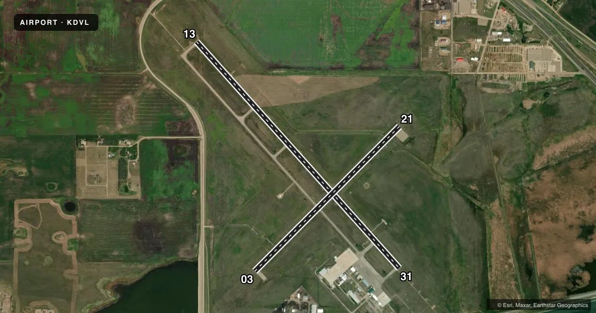
Runways & pattern
Full pagePattern entry · RWY 31
LEFT TRAFFIC| Runway | Heading (°M) | Length | Surface | Traffic |
|---|---|---|---|---|
| 13/31Favored | 131° / 311° | 6,400 ft | ASPH | Standard L |
| 03/21 | 38° / 218° | 4,314 ft | ASPH | Standard L |
Runway end performance
| End | TORA | TODA | ASDA | LDA | VGSI | Approach lights | Obstruction |
|---|---|---|---|---|---|---|---|
| 13 | 6,401' | 6,401' | 6,401' | 6,401' | PAPI 4-box left(3°) | — | — |
| 31 | 6,401' | 6,401' | 6,401' | 6,401' | PAPI 4-box left(3°) | MALSR | 29', bldg, 1400' from thr, 650' R of cntrln, slope 41 |
| 03 | 4,314' | 4,314' | 4,314' | 4,314' | PAPI 2-box left(3°) | — | 35', road, 1119' from thr, 384' R of cntrln, slope 26 |
| 21 | 4,314' | 4,314' | 4,314' | 4,314' | PAPI 2-box left(3°) | — | 38', tree, 1523' from thr, 131' R of cntrln, slope 34 |
Declared distances in feet. TORA = takeoff run available, TODA = takeoff distance, ASDA = accelerate-stop, LDA = landing distance.
Airport sketch
Runways drawn to scale from FAA survey coordinates, rendered over satellite imagery. Not for navigation.
Approaches & charts
ILS · 1
Services on the field
Fuel grades, oxygen, maintenance, ramp storage and lighting — as declared to the FAA by the airport operator.
Fuel & services
- Fuel
- 100LLA
- Oxygen (bottled)
- Not available
- Oxygen (bulk)
- Not available
- Airframe repair
- Major
- Power plant repair
- Major
- Other services
- AFRT,AGRI,AMB,CHTR,INSTR,RNTL,SALES,SURV
Ramp & ground
- Transient storage
- Tie-down
- Hangar
- Landing fee
- No fee published
- Customs
- Not available
- Lighting schedule
- SEE RMK
- Beacon schedule
- SS-SR
- Beacon
- White / Green (civil land)(WG)
- Wind indicator
- Lighted
- Segmented circle
- Yes
Fuel & FBOs
Cheapest 100LL and Jet A on the field and nearby. Always confirm with the FBO before taxi.
Airport notes
Surface conditions, obstructions, local procedures, lighting outages and other notes published with each FAA cycle.
General notes
- NUMEROUS WATERFOWL & OTHER BIRDS; DEER & JACK RABBITS ON & INVOF ARPT.
- FOR CD IF UNA TO CTC ON FSS FREQ, CTC MINNEAPOLIS ARTCC AT 651-463-5588.
Lighting notes
- ACTVT OR INCR INTST MALSR RWY 31; REIL RWY 03, 13, & 21; PAPI RWY 13/31; HIRL RWY 13/31, MIRL RWY 03/21 - CTAF.
Fuel notes
- AFUEL AVBL IREG HRS CALL 701-520-0229; SELF SVC AVGAS AVBL H24.
Runway surface & condition
- 03/21PCR VALUE: 245/F/D/X/T
- 13/31PCR VALUE: 337/F/D/X/T
- 03/21RWY 03/21 NOT AVBL FOR PART 121/PART 380 OPS WITH SKED PAX CARRYING OPS MORE THAN 9 PAX SEATS AND NON-SKED PAX CARRYING OPS MORE THAN 30 PAX SEATS.
Other notes
- 48 HRS PPR FOR UNSKED ACFT OPS WITH MORE THAN 30 PSGRS CALL AMGR 701-662-5833.
- SKED AIR CARRIER OPNS INVOLVING ACFT WITH MORE THAN 9 PSGRS ARE NOT AUTH IN EXCESS OF 15 MINS BFR OR AFT SKED ARR/DEP TIMES WO PRIOR COORD WTH ARPT MGR TO ENSURE THAT ARFF IS AVBL.
- 1FOR ATNDT AFT HRS CALL 701-520-0229.
VFR map & nearby airports
VFR sectional. Tap any ICAO chip to open that airport.
Key facts · KDVL
Answer card- ICAO
- KDVL
- Name
- DEVILS LAKE RGNL
- Location
- DEVILS LAKE, NORTH DAKOTA
- Elevation
- 1,469.4 ft MSL
- Traffic pattern altitude
- 2,469.4 ft MSL (1,000 AGL)
- Control tower
- Non-towered (use CTAF)
- Total runways
- 2
- Longest runway
- 13/31 · 6,400 ft
- Published ILS approaches
- 1
- Published frequencies
- 2
- Magnetic variation
- 7°
- Current flight rules
- VFR
- Current wind
- 330° at 7 kt
- Favored runway now
- RWY 31
Devils Lake Rgnl sits in Devils Lake, North Dakota. The field elevation is 1,469.4 ft MSL. It has two asphalt runways. The longest is runway 13/31 at 6,400 ft. Runway 03/21 is 4,314 ft. There is no control tower. CTAF and UNICOM are both 122.8.
One ILS approach is published for runway 31. Pattern altitude is not published in the facts, so use the standard 1,000 ft AGL for light piston traffic unless the current Chart Supplement says otherwise. The airport has two on-field FBOs. Foss & Meier Flight Service carries 100LL and Jet A Prist. Devils Lake Aero Service carries 100LL and Jet A. Self-serve Avgas is available 24 hours a day. Fuel for other service is available by calling ahead.
A few operational notes matter here. The field has medium and high intensity lighting on the runways. It also has approach lighting on runway 31. Birds, deer and jack rabbits are reported on and near the airport. Keep a sharp scan on arrival and departure. Runway 03/21 is not available for certain large passenger operations. Scheduled air carrier ops with more than 9 passengers also need coordination if they are inside the 15-minute window around scheduled times. If you are planning a larger or unusual operation, call the airport manager before you go.