METAR & TAF KDAY
Current METAR
Observed 17:56Z
KDAY 271756Z 22007KT 10SM FEW033 SCT180 SCT230 29/20 A2987 RMK AO2 SLP105 T02890200 10289 20211 56030
- Wind
- 220° @ 7 kt
- Visibility
- 10 SM
- Temp / Dew
- 29°C / 20°C
- Altimeter
- 29.87 inHg
- Clouds
- SCT
- Density alt
- 2,993 ft
- Ceiling
- Unlimited
- Rules
- VFR
Airport info & contacts
Manager on record, flight service, ARTCC, attendance schedule and pattern altitude — published by the FAA and refreshed every 28 days.
Location
- From city
- 9 NM N
- VFR sectional
- CINCINNATI
- ARTCC
- ZID · INDIANAPOLIS
- NOTAM facility
- DAY (NOTAM-D)
Airport manager
- Name
- DANIEL J ZENK
- Phone
- 937-454-8214
- Address
- 3600 TERMINAL DR STE 300, VANDALIA OH 45377-1095
Flight service · Hours
- FSS DAY
- DAYTON1-800-WX-BRIEF
- Attendance
- ALL
Frequencies
Tap any row to copy the frequency to your clipboard.
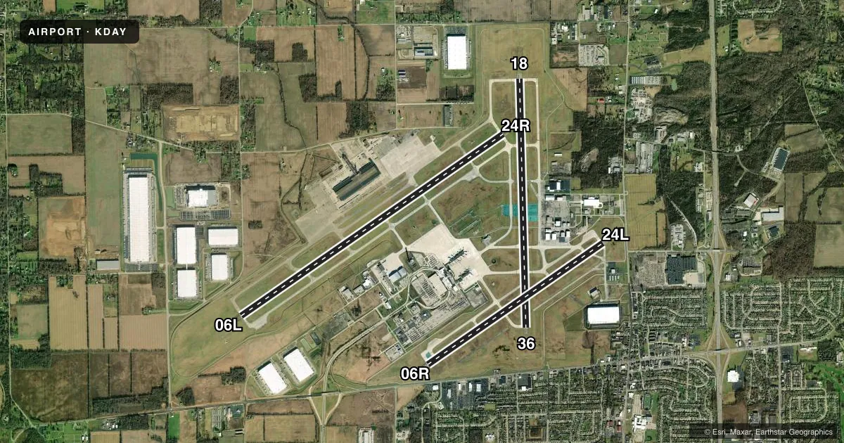
Runways & pattern
Full pagePattern entry · RWY 24R
LEFT TRAFFIC| Runway | Heading (°M) | Length | Surface | Traffic |
|---|---|---|---|---|
| 06L/24RFavored | 49° / 229° | 10,901 ft | ASPH-CONC | Standard L |
| 18/36 | 173° / 353° | 8,502 ft | ASPH | Standard L |
| 06R/24L | 49° / 229° | 7,285 ft | CONC | Standard L |
Runway end performance
| End | TORA | TODA | ASDA | LDA | VGSI | Approach lights | Obstruction |
|---|---|---|---|---|---|---|---|
| 06L | 10,900' | 10,900' | 10,900' | 10,900' | PAPI 4-box left(3°) | ALSF2 | — |
| 24R | 10,900' | 10,900' | 10,900' | 10,900' | PAPI 4-box left(3°) | MALSR | 75', tree, 3417' from thr, 197' R of cntrln, slope 42 |
| 18 | 8,502' | 8,502' | 8,502' | 8,502' | — | MALSR | 56', trees, 2636' from thr, 185' R of cntrln, slope 43 |
| 36 | 8,502' | 8,502' | 8,502' | 8,502' | PAPI 4-box left(3°) | — | 41', trees, 1050' from thr, 0' R of cntrln, slope 20 |
| 06R | 7,285' | 7,285' | 7,001' | 7,001' | PAPI 4-box left(3°) | — | 51', tree, 1230' from thr, 517' R of cntrln, slope 20 |
| 24L | 7,285' | 7,285' | 7,001' | 7,001' | PAPI 4-box left(3°) | MALSR | 25', pole, 1194' from thr, 633' R of cntrln, slope 39 |
Declared distances in feet. TORA = takeoff run available, TODA = takeoff distance, ASDA = accelerate-stop, LDA = landing distance.
Airport sketch
Runways drawn to scale from FAA survey coordinates, rendered over satellite imagery. Not for navigation.
Approaches & charts
ILS · 4
Services on the field
Fuel grades, oxygen, maintenance, ramp storage and lighting — as declared to the FAA by the airport operator.
Fuel & services
- Fuel
- 100A
- Oxygen (bottled)
- Not available
- Oxygen (bulk)
- High pressure
- Airframe repair
- Major
- Power plant repair
- Major
- Other services
- AFRT,AVNCS,CARGO,CHTR,INSTR,RNTL,SALES
Ramp & ground
- Transient storage
- Hangar
- Landing fee
- No fee published
- Customs
- Not available
- Lighting schedule
- SS-SR
- Beacon schedule
- SS-SR
- Beacon
- White / Green (civil land)(WG)
- Wind indicator
- Lighted
- Segmented circle
- No
Fuel & FBOs
Cheapest 100LL and Jet A on the field and nearby. Always confirm with the FBO before taxi.
Airport notes
Surface conditions, obstructions, local procedures, lighting outages and other notes published with each FAA cycle.
General notes
- RUNUPS PROHIBITED ON RWY 24L HOLD PAD.
- TWY Z, TWY T, & TWY S BTN RWY 06L/24R & TWY W CLSD INDEFLY.
- DEER, COYOTES, BIRDS, & WATERFOWL ON & INVOF ARPT.
- TWY C BTN TWY N & TWY Z NOT AVBL FOR GROUP IV & GTR ACFT. TWY K, TWY H, TWY J, & TWY L NOT AVBL FOR GROUP IV & GTR ACFT.
- TWY M NORTH OF RWY 06L/24R & TWY W CLSD TO ACR ACFT; ALL OTR ACFT 24 HR PPR 937-454-2010.
- TWY M NORTH OF RWY 06L/24R & TWY W EDGE LGTS NSTD.
- SNC RAMP NORTH OF RWY 06L/24R EDGE LGTS NSTD.
- TWY W SIGN LGTS OTS.
- APN HOLD PAD FOR RWY 06L CLSD DLY 2200-0600.
Runway surface & condition
- 06L/24RPCR VALUE: 608/R/C/W/T
- 06R/24LPCR VALUE: 608/R/C/W/T
- 18/36PCR VALUE: 500/F/C/X/T
Other notes
- 06L/24RNE 1400 FT CONC, SW 9501 FT ASPH.
VFR map & nearby airports
VFR sectional. Tap any ICAO chip to open that airport.
Key facts · KDAY
Answer card- ICAO
- KDAY
- Name
- JAMES M COX DAYTON INTL
- Location
- DAYTON, OHIO
- Elevation
- 1,009.1 ft MSL
- Traffic pattern altitude
- 2,009.1 ft MSL (1,000 AGL)
- Control tower
- Towered · 24
- Total runways
- 3
- Longest runway
- 06L/24R · 10,901 ft
- Published ILS approaches
- 4
- Published frequencies
- 16
- Magnetic variation
- 6°
- Current flight rules
- VFR
- Current wind
- 220° at 7 kt
- Favored runway now
- RWY 24R
James M Cox Dayton Intl is in Dayton, Ohio. The field elevation is 1,009.1 ft MSL. It has 3 runways. The longest is 10,901 ft on 06L/24R. The airport is towered 24 hours a day. KDAY has 4 ILS approaches. Pattern altitude is not published, so use 1,000 ft AGL for light piston traffic unless ATC gives you something different.
This is a Class C field with busy approach control, so expect standard tower and radar procedures. Wright Bros. Aero is on the field. It carries 100LL, Jet A and Jet A Prist. PremierFBO is also on the field. It carries 100LL, Jet A and Jet A Prist. Published remarks show several taxiway and lighting limits. Taxiways Z, T and S between 06L/24R and taxiway W are closed indefinitely. Taxiway W sign lights are out of service. Runups are prohibited on the 24L hold pad. Deer, coyotes, birds and waterfowl are reported on and near the airport. Keep a sharp scan on taxi and final. The airport also has a 24-hour prior permission note for some aircraft using taxiway M north of 06L/24R and taxiway W. Check with the airport operator or the FBO directly before arrival if your aircraft may be affected.