METAR & TAF KCXO
Current METAR
Observed 11:53Z
KCXO 271153Z 00000KT 6SM BR CLR 24/23 A3000 RMK AO2 SLP154 T02390233 10283 20239 53006
- Wind
- 000° @ 0 kt
- Visibility
- 6 SM
- Temp / Dew
- 24°C / 23°C
- Altimeter
- 30.00 inHg
- Clouds
- CLR
- Density alt
- 1,284 ft
- Ceiling
- Unlimited
- Rules
- VFR
Airport info & contacts
Manager on record, flight service, ARTCC, attendance schedule and pattern altitude — published by the FAA and refreshed every 28 days.
Location
- From city
- 37 NM N
- VFR sectional
- HOUSTON
- ARTCC
- ZHU · HOUSTON
- NOTAM facility
- CXO (NOTAM-D)
Airport manager
- Name
- JAMES BROWN
- Phone
- 936-788-8311
- Address
- 10260 CARL PICKERING MEMORIAL, CONROE TX 77303
Flight service · Hours
- FSS CXO
- MONTGOMERY COUNTY1-800-WX-BRIEF
- Attendance
- MON-FRI · 0800-1700
- SAT-SUN · 0800-1600
Frequencies
Tap any row to copy the frequency to your clipboard.
Runways & pattern
Full pagePattern entry · RWY 14
LEFT TRAFFIC| Runway | Heading (°M) | Length | Surface | Traffic |
|---|---|---|---|---|
| 14/32 | 140° / 320° | 7,501 ft | CONC | Standard L |
| 01/19 | 12° / 192° | 5,000 ft | CONC | Standard L |
Runway end performance
| End | TORA | TODA | ASDA | LDA | VGSI | Approach lights | Obstruction |
|---|---|---|---|---|---|---|---|
| 14 | — | — | — | — | PAPI 4-box left(3°) | MALSR | 73', trees, 2700' from thr, 0' R of cntrln, slope 34 |
| 32 | — | — | — | — | PAPI 2-box left(3°) | — | — |
| 01 | 5,000' | 5,000' | 5,000' | 5,000' | PAPI 2-box left(3.15°) | — | 56', trees, 1350' from thr, 460' R of cntrln, slope 20 |
| 19 | 5,000' | 5,000' | 5,000' | 5,000' | PAPI 2-box left(3°) | — | 50', trees, 1400' from thr, 460' R of cntrln, slope 24 |
Declared distances in feet. TORA = takeoff run available, TODA = takeoff distance, ASDA = accelerate-stop, LDA = landing distance.
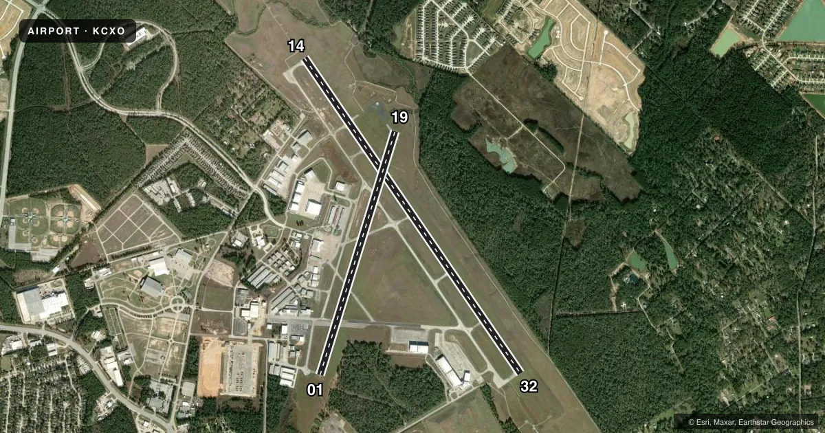
Airport sketch
Runways drawn to scale from FAA survey coordinates, rendered over satellite imagery. Not for navigation.
Approaches & charts
ILS · 1
Services on the field
Fuel grades, oxygen, maintenance, ramp storage and lighting — as declared to the FAA by the airport operator.
Fuel & services
- Fuel
- 100LLA
- Oxygen (bottled)
- HIGH/LOW
- Oxygen (bulk)
- Not available
- Airframe repair
- Major
- Power plant repair
- Major
- Other services
- AVNCS,CHTR,INSTR,RNTL
Ramp & ground
- Transient storage
- Tie-down
- Hangar
- Landing fee
- No fee published
- Customs
- Not available
- Lighting schedule
- SEE RMK
- Beacon schedule
- SS-SR
- Beacon
- White / Green (civil land)(WG)
- Wind indicator
- Lighted
- Segmented circle
- Yes
Fuel & FBOs
Cheapest 100LL and Jet A on the field and nearby. Always confirm with the FBO before taxi.
Airport notes
Surface conditions, obstructions, local procedures, lighting outages and other notes published with each FAA cycle.
General notes
- EXTSV MIL HEL ACTVTY ON ARPT.
- (A23) HELS USE RIGHT TFC.
- MILITARY: FUEL 1200-0300Z++, C936-494-4252.
- FOR CD WHEN ATCT CLSD CTC HOUSTON APCH AT 281-443-5844, TO CNL IFR AT 281-443-5888.
- EXTSV STUDENT PILOT TRNG SR-SS.
Lighting notes
- HIRL RWY 14/32 PRESET LOW INTST; TO INCR INTST & ACTVT REIL RWY 32 - CTAF.
Other notes
- INTL ARPT U.S. CUST USER FEE ARPT. CALL U.S. CUST 936-441-7750.
VFR map & nearby airports
VFR sectional. Tap any ICAO chip to open that airport.
Key facts · KCXO
Answer card- ICAO
- KCXO
- Name
- CONROE/NORTH HOUSTON RGNL
- Location
- HOUSTON, TEXAS
- Elevation
- 244.8 ft MSL
- Traffic pattern altitude
- 1,244.8 ft MSL (1,000 AGL)
- Control tower
- Towered · 0600-2100
- Total runways
- 2
- Longest runway
- 14/32 · 7,501 ft
- Published ILS approaches
- 1
- Published frequencies
- 8
- Magnetic variation
- 5°
- Current flight rules
- VFR
- Current wind
- 000° at 0 kt
- Favored runway now
- –
Conroe/North Houston Rgnl sits in Houston, Texas. Field elevation is 244.8 ft MSL. The airport has two concrete runways. The longest is 14/32 at 7,501 ft. Runway 01/19 is 5,000 ft. The tower is open daily from 0600 to 2100. One ILS is published for runway 14. Pattern altitude is not published, so use 1,000 ft AGL for light piston traffic unless ATC gives you something different.
This is a busy field. Published remarks call out extensive student pilot activity from sunrise to sunset. There is also extensive military helicopter activity on the airport. Helicopters use right-hand traffic. If you are planning a first trip in, watch the southwest side of the airport for the noise-sensitive area. Runway 14/32 has high-intensity lights that start at low intensity. Use the CTAF to increase intensity and to activate the runway end identifier lights on runway 32.
Two on-field FBOs are listed. Galaxy FBO carries 100LL and Jet A Prist. General Aviation Services carries 100LL and Jet A Prist. This is also a U.S. Customs user fee airport. Call U.S. Customs before arrival if you need that service. When the tower is closed, clearance delivery goes through Houston Approach. For IFR cancellation, use the published Houston Approach number.