METAR & TAF KCWA
Current METAR
Observed 15:50Z
KCWA 271550Z 24010KT 10SM OVC015 28/25 A2968
- Wind
- 240° @ 10 kt
- Visibility
- 10 SM
- Temp / Dew
- 28°C / 25°C
- Altimeter
- 29.68 inHg
- Clouds
- OVC
- Density alt
- 3,441 ft
- Ceiling
- 1,500 ft AGL
- Rules
- MVFR
Airport info & contacts
Manager on record, flight service, ARTCC, attendance schedule and pattern altitude — published by the FAA and refreshed every 28 days.
Location
- From city
- 3 NM SE
- VFR sectional
- GREEN BAY
- ARTCC
- ZMP · MINNEAPOLIS
- NOTAM facility
- CWA (NOTAM-D)
Airport manager
- Name
- BRIAN GREFE
- Phone
- 715-693-2147
- Address
- 100 CWA DR. SUITE 227, MOSINEE WI 54455
Flight service · Hours
- FSS GRB
- GREEN BAY1-800-WX-BRIEF
- Attendance
- ALL
Frequencies
Tap any row to copy the frequency to your clipboard.
Runways & pattern
Full pagePattern entry · RWY 26
LEFT TRAFFIC| Runway | Heading (°M) | Length | Surface | Traffic |
|---|---|---|---|---|
| 08/26Favored | 77° / 257° | 7,724 ft | CONC | Standard L |
| 17/35 | 170° / 350° | 6,501 ft | CONC | Standard L |
Runway end performance
| End | TORA | TODA | ASDA | LDA | VGSI | Approach lights | Obstruction |
|---|---|---|---|---|---|---|---|
| 08 | 7,629' | 7,629' | 7,629' | 7,724' | PAPI 4-box right(3°) | MALSR | 18', bldg, 960' from thr, 400' R of cntrln, slope 42 |
| 26 | 7,724' | 7,724' | 7,724' | 7,629' | PAPI 4-box left(3°) | — | — |
| 17 | 6,501' | 6,501' | 6,501' | 6,501' | PAPI 4-box left(3°) | — | 82', stack, 2720' from thr, 840' R of cntrln, slope 30 |
| 35 | 6,501' | 6,501' | 6,501' | 6,501' | PAPI 4-box left(3°) | MALSR | — |
Declared distances in feet. TORA = takeoff run available, TODA = takeoff distance, ASDA = accelerate-stop, LDA = landing distance.
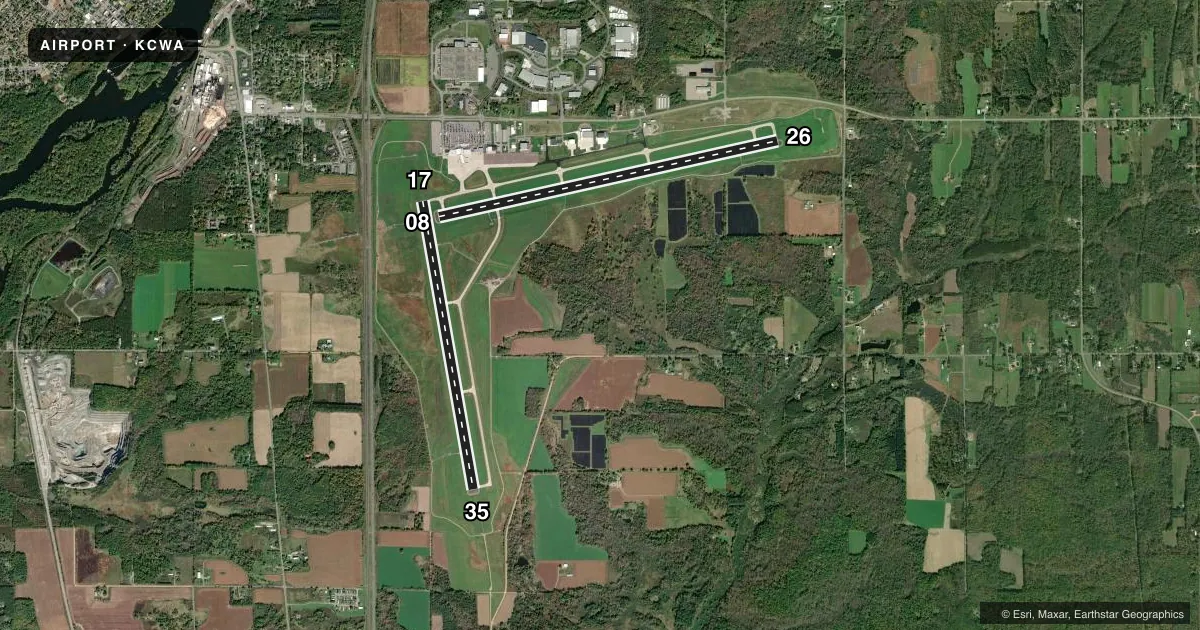
Airport sketch
Runways drawn to scale from FAA survey coordinates, rendered over satellite imagery. Not for navigation.
Approaches & charts
ILS · 2
Services on the field
Fuel grades, oxygen, maintenance, ramp storage and lighting — as declared to the FAA by the airport operator.
Fuel & services
- Fuel
- 100LLA
- Oxygen (bottled)
- Not available
- Oxygen (bulk)
- High pressure
- Airframe repair
- Major
- Power plant repair
- Major
- Other services
- AFRT,AMB,AVNCS,CARGO,CHTR,INSTR,RNTL
Ramp & ground
- Transient storage
- Tie-down
- Hangar
- Landing fee
- No fee published
- Customs
- Not available
- Lighting schedule
- SEE RMK
- Beacon schedule
- SS-SR
- Beacon
- White / Green (civil land)(WG)
- Wind indicator
- Lighted
- Segmented circle
- No
Fuel & FBOs
Cheapest 100LL and Jet A on the field and nearby. Always confirm with the FBO before taxi.
Airport notes
Surface conditions, obstructions, local procedures, lighting outages and other notes published with each FAA cycle.
General notes
- TWY E NORTH OF TWY A NOT AVBL FOR ACR OPS; GA & CARGO ACFT RSTRD TO LESS THAN 100000 LBS.
- LDG FEE FOR ACFT PRVDG COML SVCS.
Lighting notes
- WHEN ATCT CLSD, HIRL RWY 8/26 PRESET LOW; TO INCR INTST AND ACTVT MALSR RWY 8 & 35; REIL RWY 17 & 26; HIRL RWY 8/26 & 17/35 - CTAF. RWY 8, 17, 26 & 35 PAPI OPRS CONSLY.
Runway surface & condition
- 08/26PCR VALUE: 780/R/D/W/T
- 17/35PCR VALUE: 910/R/D/W/T
Approach & departure obstructions
- 26PAPI UNUSBL BYD 6 DEGS R OF CNTRLN.
Other notes
- MANAGEREXT 7.
VFR map & nearby airports
VFR sectional. Tap any ICAO chip to open that airport.
Key facts · KCWA
Answer card- ICAO
- KCWA
- Name
- CENTRAL WISCONSIN
- Location
- MOSINEE, WISCONSIN
- Elevation
- 1,277.3 ft MSL
- Traffic pattern altitude
- 2,277.3 ft MSL (1,000 AGL)
- Control tower
- Towered · 0600-2200
- Total runways
- 2
- Longest runway
- 08/26 · 7,724 ft
- Published ILS approaches
- 2
- Published frequencies
- 7
- Magnetic variation
- 0°
- Current flight rules
- MVFR
- Current wind
- 240° at 10 kt
- Favored runway now
- RWY 26
Central Wisconsin Airport (KCWA) sits in Mosinee, Wisconsin. The field elevation is 1,277.3 ft MSL. KCWA has two concrete runways. The longest is 08/26 at 7,724 ft. Runway 17/35 is 6,501 ft. The airport is towered. Tower hours are 0600 to 2200. Two ILS approaches are published. They are for runway ends 08 and 35.
Pattern altitude is not published in the facts, so use the standard 1,000 ft AGL for light piston traffic unless ATC or the current FAA Chart Supplement says otherwise. Ovation CWA is on the field. It carries 100LL, Jet A and Jet A Prist. The airport sits in a busy commercial environment. There is a landing fee for aircraft providing commercial services. General aviation and cargo aircraft are restricted to less than 100,000 pounds. Taxiway E north of taxiway A is not available for aircraft rescue operations.
When the tower is closed, runway lighting changes are activated on CTAF. The runway 26 PAPI is unusable beyond 6 degrees right of centerline. Check the current FAA Chart Supplement for any noise or curfew restrictions before flying in. Use the current Chart Supplement or call the airport operator if you need anything that is not covered here.