METAR & TAF KCSM
Current METAR
Observed 20:53Z
KCSM 232053Z 13009G21KT 10SM FEW065 38/21 A2999 RMK AO2 SLP123 T03780211 56018
- Wind
- 130° @ 9G21 kt
- Visibility
- 10 SM
- Temp / Dew
- 38°C / 21°C
- Altimeter
- 29.99 inHg
- Clouds
- FEW
- Density alt
- 5,057 ft
- Ceiling
- Unlimited
- Rules
- VFR
Airport info & contacts
Manager on record, flight service, ARTCC, attendance schedule and pattern altitude — published by the FAA and refreshed every 28 days.
Location
- From city
- 2 NM SW
- VFR sectional
- DALLAS-FT WORTH
- ARTCC
- ZFW · FORT WORTH
- NOTAM facility
- CSM (NOTAM-D)
Airport manager
- Name
- JOE CALLAHAN
- Phone
- 580-562-3500
- Address
- 121 1ST STREET, BOX 689, BURNS FLAT OK 73624
Flight service · Hours
- FSS MLC
- MC ALESTER1-800-WX-BRIEF
- Attendance
- MON-FRI · 0800-1700
Frequencies
Tap any row to copy the frequency to your clipboard.
Runways & pattern
Full pagePattern entry · RWY 17R
RIGHT TRAFFIC| Runway | Heading (°M) | Length | Surface | Traffic |
|---|---|---|---|---|
| 17R/35LFavored | 175° / 355° | 13,503 ft | CONC | 17R R |
| 17L/35R | 175° / 355° | 5,193 ft | CONC | 35R R |
Runway end performance
| End | TORA | TODA | ASDA | LDA | VGSI | Approach lights | Obstruction |
|---|---|---|---|---|---|---|---|
| 17R | — | — | — | — | PAPI 4-box left(3°) | — | — |
| 35L | — | — | — | — | PAPI 4-box left(3°) | — | — |
Declared distances in feet. TORA = takeoff run available, TODA = takeoff distance, ASDA = accelerate-stop, LDA = landing distance.
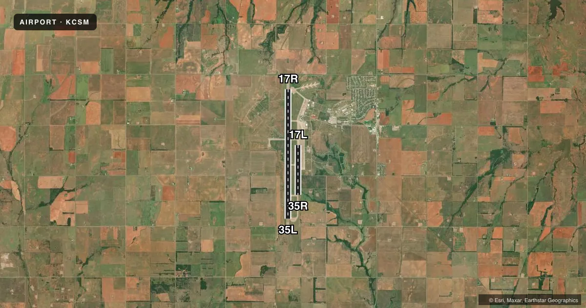
Airport sketch
Runways drawn to scale from FAA survey coordinates, rendered over satellite imagery. Not for navigation.
Approaches & charts
ILS · 1
Services on the field
Fuel grades, oxygen, maintenance, ramp storage and lighting — as declared to the FAA by the airport operator.
Fuel & services
- Fuel
- A1+
- Contract fuel
- Not available
- Oxygen (bottled)
- High pressure
- Oxygen (bulk)
- Not available
- Airframe repair
- Not available
- Power plant repair
- Not available
Ramp & ground
- Transient storage
- Hangar
- Landing fee
- Yes
- Customs
- Not available
- Lighting schedule
- SEE RMK
- Beacon schedule
- SS-SR
- Beacon
- White / Green (civil land)(WG)
- Wind indicator
- Lighted
- Segmented circle
- No
Fuel & FBOs
Cheapest 100LL and Jet A on the field and nearby. Always confirm with the FBO before taxi.
Airport notes
Surface conditions, obstructions, local procedures, lighting outages and other notes published with each FAA cycle.
General notes
- MIL JET TRNG: HVY JETS SFC TO 5000 FT WI 25 NMR. EXTSV STUDENT PILOT TRNG FM SFC TO 5000 FT WI 10 NMR BTN 0900-1200.
- RWY 17L/35R LAID OUT & MRKD ON RWY 17L/35R PARL TWY.
- MIL JET NGT VISION TRNG: CTC ATCT 10 MINS PRIOR TO LDG AFT SS TO ADJUST ARPT LGTS.
- VFR ACFT ADZD TO CTC ATC 15 NM OUT FOR SEQG.
- MIL ARFF AVBL EXCP WKNDS AND FED HOL.
Lighting notes
- ACTVT REIL RWY 17R & 35L; HIRL RWY 17R/35L; TWY LGT; WDI LGT - CTAF. PAPI RWY 17R & 35L ON CONSLY.
Fuel notes
- A1+24 HR JET-A1+ FUEL & OTR SVC AVBL - CTC 405-267-4010.
Runway surface & condition
- 17L/35RDALGT VFR ONLY.
- 17R/35LNSTD; 75 FT FM RWY EDGE.
Other notes
- THIS AIRPORT HAS BEEN SURVEYED BY THE NATIONAL GEODETIC SURVEY.
- ESTABLISHED PRIOR TO 1958-SUBSEQUENT MILITARY CONST.NOT AIRSPACED.
- LDG FEE FOR ACFT GTR THAN 50,000 LBS.
- 1ATCT CLSD FED HOL.
VFR map & nearby airports
VFR sectional. Tap any ICAO chip to open that airport.
Key facts · KCSM
Answer card- ICAO
- KCSM
- Name
- INFINITY ONE OKLAHOMA SPACEPORT
- Location
- BURNS FLAT, OKLAHOMA
- Elevation
- 1,922.1 ft MSL
- Traffic pattern altitude
- 2,922.1 ft MSL (1,000 AGL)
- Control tower
- Towered · 0900-0100 MON-FRI ; EXCEPT FEDERAL HOL.
- Total runways
- 2
- Longest runway
- 17R/35L · 13,503 ft
- Published ILS approaches
- 1
- Published frequencies
- 8
- Magnetic variation
- 5°
- Current flight rules
- VFR
- Current wind
- 130° at 9 kt
- Favored runway now
- RWY 17R
Clinton/Sherman is in Burns Flat, Oklahoma. Field elevation is 1,922.1 ft MSL. The airport has 2 concrete runways. The longest is 17R/35L at 13,503 ft. The tower is open 0900-0100 Monday through Friday except federal holidays. One ILS is published for runway 17R. Pattern altitude is not published, so use standard 1,000 ft AGL for light piston traffic unless ATC or the current Chart Supplement says otherwise.
Lux Air Jet Centers is on the field. It carries Jet A and Jet A Prist. Call (405) 267-4010 for current service details. Published remarks note 24-hour Jet-A1 plus service. The airport is not in controlled airspace. VFR pilots are advised to call ATC 15 NM out for sequencing. That matters here because military jet training can run heavy traffic from the surface to 5,000 ft within 25 NM. Student pilot training also occurs from the surface to 5,000 ft within 10 NM between 0900 and 1200. Runway 17L/35R is daylight use only. If you are planning a night arrival or a heavier aircraft, verify the current Chart Supplement and coordinate with the airport operator or the FBO before you go.