METAR & TAF KCLE
Current METAR
Observed 19:51Z
KCLE 271951Z 24011KT 10SM BKN250 29/20 A2980 RMK AO2 SLP098 T02890200 $
- Wind
- 240° @ 11 kt
- Visibility
- 10 SM
- Temp / Dew
- 29°C / 20°C
- Altimeter
- 29.80 inHg
- Clouds
- BKN
- Density alt
- 2,820 ft
- Ceiling
- 25,000 ft AGL
- Rules
- VFR
Airport info & contacts
Manager on record, flight service, ARTCC, attendance schedule and pattern altitude — published by the FAA and refreshed every 28 days.
Location
- From city
- 9 NM SW
- VFR sectional
- DETROIT
- ARTCC
- ZOB · CLEVELAND
- NOTAM facility
- CLE (NOTAM-D)
Airport manager
- Name
- FRANK WILLIAMS
- Phone
- 216-265-6127
- Address
- PO BOX 81009, 5300 RIVERSIDE DR, CLEVELAND OH 44181-3130
Flight service · Hours
- FSS CLE
- CLEVELAND1-800-WX-BRIEF
- Attendance
- ALL
Frequencies
Tap any row to copy the frequency to your clipboard.
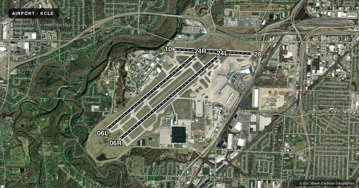
Runways & pattern
Full pagePattern entry · RWY 24L
LEFT TRAFFIC| Runway | Heading (°M) | Length | Surface | Traffic |
|---|---|---|---|---|
| 06R/24LFavored | 42° / 222° | 9,953 ft | CONC | Standard L |
| 06L/24R | 42° / 222° | 9,000 ft | CONC | Standard L |
| 10/28 | 85° / 265° | 6,018 ft | ASPH-CONC | Standard L |
Runway end performance
| End | TORA | TODA | ASDA | LDA | VGSI | Approach lights | Obstruction |
|---|---|---|---|---|---|---|---|
| 06R | 9,956' | 9,956' | 9,956' | 8,029' | PAPI 4-box left(3°) | MALSR | 80', trees, 3010' from thr, 370' R of cntrln, slope 35 |
| 24L | 9,956' | 9,956' | 9,956' | 9,956' | PAPI 4-box right(3°) | MALSR | — |
| 06L | 9,000' | 9,000' | 9,000' | 9,000' | PAPI 4-box left(3°) | ALSF2 | 97', trees, 3689' from thr, 847' R of cntrln, slope 35 |
| 24R | 9,000' | 9,000' | 9,000' | 9,000' | PAPI 4-box right(3°) | ALSF2 | — |
| 10 | 6,018' | 6,018' | 6,018' | 6,018' | PAPI 4-box left(3°) | — | 51', tree, 262' from thr, 490' R of cntrln, slope 1 |
| 28 | 6,018' | 6,018' | 6,018' | 6,018' | PAPI 4-box right(3°) | MALSF | 25', pole, 1252' from thr, 392' R of cntrln, slope 42 |
Declared distances in feet. TORA = takeoff run available, TODA = takeoff distance, ASDA = accelerate-stop, LDA = landing distance.
Airport sketch
Runways drawn to scale from FAA survey coordinates, rendered over satellite imagery. Not for navigation.
Approaches & charts
ILS · 5
Services on the field
Fuel grades, oxygen, maintenance, ramp storage and lighting — as declared to the FAA by the airport operator.
Fuel & services
- Fuel
- 100LLA1+
- Oxygen (bottled)
- HIGH/LOW
- Oxygen (bulk)
- HIGH/LOW
- Airframe repair
- Major
- Power plant repair
- Major
- Other services
- AFRT,AVNCS,CHTR,RNTL
Ramp & ground
- Transient storage
- Tie-down
- Hangar
- Landing fee
- Yes
- Customs
- Available
- Beacon schedule
- SS-SR
- Beacon
- White / Green (civil land)(WG)
- Wind indicator
- Lighted
- Segmented circle
- No
Fuel & FBOs
Cheapest 100LL and Jet A on the field and nearby. Always confirm with the FBO before taxi.
Airport notes
Surface conditions, obstructions, local procedures, lighting outages and other notes published with each FAA cycle.
General notes
- DEER, COYOTES, & BIRDS INCLG WATERFOWL ON & INVOF ARPT.
- ADCUS AVBL MON-SUN DURING HOURS 0800-2000LCL; LTD AVBLTY DURING OFF HOURS; ALL REQ FOR SVC MUST BE MADE WITH THE U.S. CUST SVC OFC LCTD AT GATE A-14 CALL (216) 267-3600 DURG LISTED HRS.
- NASA GLENN RESEARCH CENTER; NASA RAMP PPR CALL 216-433-2031; 0800-1730 MON-FRI. CONTACT NASA OPNS ON FREQ 122.925 WITHIN 50 NM.
- PAD 2 AND TAXILANE Y1 RSTRD TO GROUP II ACFT LESS THAN 79 FT WINGSPAN.
- ALL APCHS ARE OVR NOISE SENSITIVE AREAS. ARPT LATE NGT NOISE ABATEMENT PROCEDURES ARE IN EFFECT 2300-0600. ADDITIONAL NOISE ABATEMENT PROCEDURES ARE IN EFFECT CALL AMGR NORMAL BUSINESS HRS AT 216-265-6090.
- TWYS CLSD OCT-APR TO SUPPORT DEICING OPS: TWY M; TWY J2; TWY M1 BTN TWY L & TWY J1; TWY M2 BTN TWY L & TWY J1.
- RAMP AREA CONCOURSE D BTN GATES D1, D28 CLSD EXC ACFT WINGSPAN LESS THAN 86 FT.
- PAD 3 BAYS 1-5 CLOSED TO ACFT WITH WINGSPAN OVER 134 FT.
- PAD 3 BAY 6 CLOSED TO ACFT WITH WINGSPAN OVER 94 FT.
- TXL H CLSD TO ACFT WITH WINGSPAN OVR 171 FT.
- TWY F CLSD TO ACFT WITH WINGSPAN OVR 118 FT.
Runway surface & condition
- 06L/24RPCR VALUE: 1080/R/B/W/T
- 06R/24LPCR VALUE: 840/R/B/W/T
- 10/28PCR VALUE: 680/R/B/W/T
Approach & departure obstructions
- 06LRWY 6L ALSO HAS LGTD PLINE 99 FT ABV RWY END, 4266 FT FM RWY END, 966 FT L OF CNTRLN, 41:1 OBSTN CLNC SLOPE.
- 10UNUSBL BYD 8 DEGS L & R OF CNTRLN.
Arresting gear
- 10_EMASEMAS - ENGINEERED MATERIALS ARRESTING SYSTEM, 170 FT IN WIDE X 275 FT LENGTH, LOCATED AT DEPARTURE END OF RY 10.
- 28_EMASEMAS - ENGINEERED MATERIALS ARRESTING SYSTEM, 170 FT IN WIDE 365 FT IN LENGTH, LOCATED AT DEPARTURE END OF RY 28.
VFR map & nearby airports
VFR sectional. Tap any ICAO chip to open that airport.
Key facts · KCLE
Answer card- ICAO
- KCLE
- Name
- CLEVELAND-HOPKINS INTL
- Location
- CLEVELAND, OHIO
- Elevation
- 799.5 ft MSL
- Traffic pattern altitude
- 1,799.5 ft MSL (1,000 AGL)
- Control tower
- Towered · 24
- Total runways
- 3
- Longest runway
- 06R/24L · 9,953 ft
- Published ILS approaches
- 5
- Published frequencies
- 17
- Magnetic variation
- 8°
- Current flight rules
- VFR
- Current wind
- 240° at 11 kt
- Favored runway now
- RWY 24L
Cleveland-Hopkins Intl sits in Cleveland, Ohio. Field elevation is 799.5 ft MSL. The airport has 3 runways. The longest is 9,953 ft on 06R/24L. The tower is open 24 hours.
This is a busy Class B field. Check the current chart before you go if you need the exact airspace picture for your route. Five ILS approaches are published for runway ends 06L, 06R, 24L, 24R and 28. Pattern altitude is not published in the facts, so use standard 1,000 ft AGL for light piston traffic unless ATC gives you something different.
Atlantic Aviation is on the field. It carries 100LL and Jet A. Jets FBO is also on the field. It carries Jet A. Deicing and anti-icing services are available from 0800 to 2000 local. Requests go through the U.S. Customs Service office at gate A-14. Late-night noise abatement is in effect from 2300 to 0600. All approaches cross noise-sensitive areas. Brief your arrival early and expect ATC to keep things tight.
Watch for deer, coyotes, birds and waterfowl in the area. Taxiway and ramp limits matter here too. Some taxiways and Pad 3 bays have wingspan restrictions. NASA ramp use needs prior permission. If you are bringing a larger airframe, verify the current taxi restrictions with the airport operator before arrival.