METAR & TAF KCAK
Current METAR
Observed 19:51Z
KCAK 271951Z 23008KT 10SM FEW040 BKN250 29/18 A2983 RMK AO2 SLP092 T02940183 $
- Wind
- 230° @ 8 kt
- Visibility
- 10 SM
- Temp / Dew
- 29°C / 18°C
- Altimeter
- 29.83 inHg
- Clouds
- BKN
- Density alt
- 3,311 ft
- Ceiling
- 25,000 ft AGL
- Rules
- VFR
Airport info & contacts
Manager on record, flight service, ARTCC, attendance schedule and pattern altitude — published by the FAA and refreshed every 28 days.
Location
- From city
- 10 NM SE
- VFR sectional
- DETROIT
- ARTCC
- ZOB · CLEVELAND
- NOTAM facility
- CAK (NOTAM-D)
Airport manager
- Name
- RENATO CAMACHO
- Phone
- 330-754-5233
- Address
- 5400 LAUBY RD, NORTH CANTON OH 44720
Flight service · Hours
- FSS CLE
- CLEVELAND1-800-WX-BRIEF
- Attendance
- ALL
Frequencies
Tap any row to copy the frequency to your clipboard.
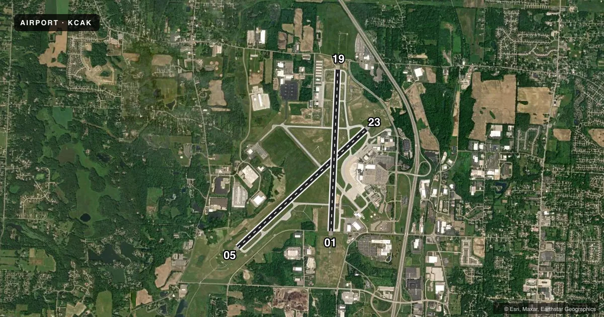
Runways & pattern
Full pagePattern entry · RWY 23
LEFT TRAFFIC| Runway | Heading (°M) | Length | Surface | Traffic |
|---|---|---|---|---|
| 05/23Favored | 40° / 220° | 8,204 ft | ASPH | Standard L |
| 01/19 | 355° / 175° | 7,601 ft | ASPH | Standard L |
Runway end performance
| End | TORA | TODA | ASDA | LDA | VGSI | Approach lights | Obstruction |
|---|---|---|---|---|---|---|---|
| 05 | 8,204' | 8,204' | 8,204' | 8,204' | PAPI 4-box left(3°) | MALSR | — |
| 23 | 8,204' | 8,204' | 8,204' | 8,204' | PAPI 4-box left(3°) | MALSR | — |
| 01 | 7,601' | 7,601' | 7,007' | 7,007' | — | MALSR | — |
| 19 | 7,601' | 7,601' | 7,601' | 7,007' | PAPI 4-box left(3°) | MALSR | — |
Declared distances in feet. TORA = takeoff run available, TODA = takeoff distance, ASDA = accelerate-stop, LDA = landing distance.
Airport sketch
Runways drawn to scale from FAA survey coordinates, rendered over satellite imagery. Not for navigation.
Approaches & charts
ILS · 4
Services on the field
Fuel grades, oxygen, maintenance, ramp storage and lighting — as declared to the FAA by the airport operator.
Fuel & services
- Fuel
- 100LLA
- Oxygen (bottled)
- Not available
- Oxygen (bulk)
- HIGH/LOW
- Airframe repair
- Major
- Power plant repair
- Major
- Other services
- AFRT,AVNCS,CARGO,CHTR,INSTR,RNTL,SALES
Ramp & ground
- Transient storage
- Tie-down
- Hangar
- Landing fee
- Yes
- Customs
- Not available
- Beacon schedule
- SS-SR
- Beacon
- White / Green (civil land)(WG)
- Wind indicator
- Lighted
- Segmented circle
- No
Fuel & FBOs
Cheapest 100LL and Jet A on the field and nearby. Always confirm with the FBO before taxi.
Airport notes
Surface conditions, obstructions, local procedures, lighting outages and other notes published with each FAA cycle.
General notes
- DEER & BIRDS ON & INVOF ARPT.
- ALL ACFT TAXIING ON AIR CAMIS RAMP & NORTH HANGAR AREAS NOT VISIBLE FM ATCT.
- TWY E EAST OF TWY B CLSD TO ACFT OVER 118 FT WINGSPAN.
- FOR CD CTC CLEVELAND ARTCC AT 440-774-0223.
Runway surface & condition
- 01/19PCR VALUE: 410/F/B/X/U
- 05/23PCR VALUE: 410/F/B/X/U
Other notes
- ARFF SVC NOT AVBL 0100-0500 LCL DLY. ONE HOUR PPR FOR UNSKED ACR OPNS; CALL AMGR 330-499-4059.
- MULTI ENG ONLY
VFR map & nearby airports
VFR sectional. Tap any ICAO chip to open that airport.
Key facts · KCAK
Answer card- ICAO
- KCAK
- Name
- AKRON-CANTON RGNL
- Location
- AKRON, OHIO
- Elevation
- 1,225.5 ft MSL
- Traffic pattern altitude
- 2,225.5 ft MSL (1,000 AGL)
- Control tower
- Towered · 24
- Total runways
- 2
- Longest runway
- 05/23 · 8,204 ft
- Published ILS approaches
- 4
- Published frequencies
- 17
- Magnetic variation
- 7°
- Current flight rules
- VFR
- Current wind
- 230° at 8 kt
- Favored runway now
- RWY 23
Akron-Canton Rgnl is in Akron, Ohio. Field elevation is 1,225.5 ft MSL. The airport has two asphalt runways. The longest is 8,204 ft on 05/23. The tower is open 24 hours. Four ILS approaches are published for the field. The runway ends listed are 01, 05, 19 and 23.
Pattern altitude is not published in the facts. Use the standard 1,000 ft AGL for light piston traffic unless the current Chart Supplement says otherwise. That puts the common pattern reference at 2,225.5 ft MSL based on the field elevation here. Castle Aviation is on the field. It carries 100LL and Jet A. Avflight Akron-Canton is also on the field. It carries 100LL, Jet A and Jet A Prist.
A few operational notes matter here. Clearance delivery is handled through Cleveland ARTCC by phone per the published remarks. Taxiway E east of Taxiway B is closed to aircraft over 118 ft wingspan. ARFF is not available from 0100 to 0500 local daily. Unscheduled operations need one hour prior permission from the airport manager. Deer and birds are reported on and near the airport. Check the current Chart Supplement for any noise or curfew restrictions before flying in.