METAR & TAF KBNA
Current METAR
Observed 07:53Z
KBNA 280753Z 21004KT 10SM CLR 27/22 A2980 RMK AO2 SLP081 T02670222 $
- Wind
- 210° @ 4 kt
- Visibility
- 10 SM
- Temp / Dew
- 27°C / 22°C
- Altimeter
- 29.80 inHg
- Clouds
- CLR
- Density alt
- 2,332 ft
- Ceiling
- Unlimited
- Rules
- VFR
Airport info & contacts
Manager on record, flight service, ARTCC, attendance schedule and pattern altitude — published by the FAA and refreshed every 28 days.
Location
- From city
- 5 NM SE
- VFR sectional
- ATLANTA
- ARTCC
- ZME · MEMPHIS
- NOTAM facility
- BNA (NOTAM-D)
Airport manager
- Name
- ADAM FLOYD
- Phone
- 615-275-1546
- Address
- 140 BNA PARK DR. SUITE 520, NASHVILLE TN 37214
Flight service · Hours
- FSS BNA
- NASHVILLE1-800-WX-BRIEF
- Attendance
- ALL
Frequencies
Tap any row to copy the frequency to your clipboard.
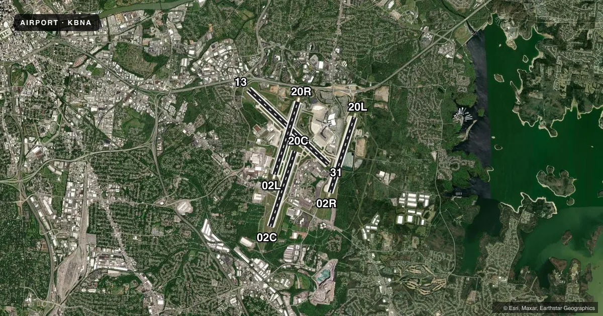
Runways & pattern
Full pagePattern entry · RWY 20L
LEFT TRAFFIC| Runway | Heading (°M) | Length | Surface | Traffic |
|---|---|---|---|---|
| 13/31 | 130° / 310° | 11,030 ft | CONC | Standard L |
| 02R/20LFavored | 15° / 195° | 8,001 ft | CONC | Standard L |
| 02C/20C | 15° / 195° | 8,001 ft | CONC | Standard L |
| 02L/20R | 15° / 195° | 7,704 ft | CONC | Standard L |
Runway end performance
| End | TORA | TODA | ASDA | LDA | VGSI | Approach lights | Obstruction |
|---|---|---|---|---|---|---|---|
| 13 | 10,288' | 11,029' | 10,288' | 9,487' | — | — | trees, slope 34 |
| 31 | 10,228' | 11,029' | 10,228' | 9,487' | PAPI 4-box right(3°) | — | tree, slope 50 |
| 02R | 8,000' | 8,000' | 8,000' | 8,000' | — | ALSF2 | — |
| 20L | 8,000' | 8,000' | 8,000' | 8,000' | PAPI 4-box left(3°) | MALSR | — |
| 02C | 8,001' | 8,001' | 7,601' | 7,601' | PAPI 4-box left(3°) | MALSR | — |
| 20C | 8,001' | 8,001' | 8,001' | 8,001' | PAPI 4-box left(3°) | — | — |
| 02L | 7,702' | 7,702' | 7,702' | 7,702' | PAPI 4-box right(3°) | ALSF2 | — |
| 20R | 7,702' | 7,702' | 7,702' | 7,702' | PAPI 4-box right(3°) | MALSF | — |
Declared distances in feet. TORA = takeoff run available, TODA = takeoff distance, ASDA = accelerate-stop, LDA = landing distance.
Airport sketch
Runways drawn to scale from FAA survey coordinates, rendered over satellite imagery. Not for navigation.
Approaches & charts
ILS · 6
Services on the field
Fuel grades, oxygen, maintenance, ramp storage and lighting — as declared to the FAA by the airport operator.
Fuel & services
- Fuel
- 100LLA
- Oxygen (bottled)
- Low pressure
- Oxygen (bulk)
- Low pressure
- Airframe repair
- Major
- Power plant repair
- Major
- Other services
- AFRT,AMB,AVNCS,CARGO,CHTR,INSTR,RNTL,SALES
Ramp & ground
- Transient storage
- Tie-down
- Hangar
- Landing fee
- No fee published
- Customs
- Not available
- Lighting schedule
- SS-SR
- Beacon schedule
- SS-SR
- Beacon
- White / Green (civil land)(WG)
- Wind indicator
- Lighted
- Segmented circle
- No
Fuel & FBOs
Cheapest 100LL and Jet A on the field and nearby. Always confirm with the FBO before taxi.
Airport notes
Surface conditions, obstructions, local procedures, lighting outages and other notes published with each FAA cycle.
General notes
- CTN: READ BACK & COMPLIANCE OF RWY HLDG INSTRN RQR; SPCLY TWY K & RWY 20C, TWY L AT RWY 13 & TWY H AT RWY 31.
- FLT NOTIFICATION SVC (ADCUS) AVBL.
- TBJT RWY NOISE ABATEMENT PROC; MIL TBJT USE RWY 13/31 FOR ARR & DEP.
- 180 DEG TURNS OVR 12500 LBS NA ON ASPH SFC.
- FLT OVR MAIN TRML NA.
- BIRD ACT ON & INVOF ARPT.
- DO NOT CONFUSE TWY S FOR RWY 20C.
- MILITARY: ANG: PPR RQR 48 HOURS PRIOR ALL TRAN ACFT. CASHH OPS C629-332-9768. MNT 49.95, 373.9, OR 149.8 ON THE RAMP. NO SVCS PRVDD BY ARNG. CTC FBO FOR SVCS.
- MIL & ACFT MORE THAN 12500 LB PRAC APCH NA; PRAC APCH BTN 2300-0700 NA.
- TRML APRON TAX BTN ACR PUSHBACK OPS & GATES NA.
- ADHERE TO TWY & TXL CNTRLN WI TRML APRON.
- BNA SVC NORTH RAMP TWR OPN DLY- 0400- 0100 - 131.90.
- PAVEMENT ON W SIDE OF RWY 2R/20L BTN TXY H3 & H4 MKD AS A VEHICLE ACES ROAD ONLY.
- BNA SVC SOUTH RAMP TWR OPN DLY- 0400-0100 - 129.95.
- TRML APRON TXL Z, Y1, Y2 & TXL Y BTN TXL Y3 & Y4 CLSD TO WINGSPAN MORE THAN 118 FT.
- BNA SVC CNTRL RAMP/GUITAR PICK RAMP TWR OPN DLY 0400-0100 - 131.375.
- 96 HR PPR FOR WINGSPAN GTR THAN 214 FT - 615-275-1612.
- PPR BFR GA & CARGO PROCD TO AIRLINE TRML GATE FOR DEICE OPS.
- PILOTS CONDUCTING EFVS OPS; BE AWARE LED ALS IN USE RWY 20R.
- LGTD PERIMETER FENCE LCTD IN ROFA, WEST OF RWY 2C/20C AT MIDPT.
Runway surface & condition
- 02C/20CPCR VALUE: 615/R/A/W/T
- 02L/20RPCR VALUE: 897/R/A/W/T
- 02R/20LPCR VALUE: 727/R/A/W/T
- 13/31PCR VALUE: 762/R/A/W/T
Approach & departure obstructions
- 13LGTD JET BLAST FENCE 568 FT MSL 1167 FT NW THR.
- 31LGTD JET BLAST FENCE 598 FT MSL 1100 FT SE THR.
- 20RMAY BE SUBJ TO VISUAL INTFC FM ACFT HLDG OR STOPPED AT TWY A5.
- 13APCH RATIO 50:1 TO DTHR.
- 31APCH RATIO 50:1 TO DTHR.
VFR map & nearby airports
VFR sectional. Tap any ICAO chip to open that airport.
Key facts · KBNA
Answer card- ICAO
- KBNA
- Name
- NASHVILLE INTL
- Location
- NASHVILLE, TENNESSEE
- Elevation
- 599 ft MSL
- Traffic pattern altitude
- 1,599 ft MSL (1,000 AGL)
- Control tower
- Towered · 24
- Total runways
- 4
- Longest runway
- 13/31 · 11,030 ft
- Published ILS approaches
- 6
- Published frequencies
- 17
- Magnetic variation
- 3°
- Current flight rules
- VFR
- Current wind
- 210° at 4 kt
- Favored runway now
- RWY 20L
Nashville Intl is in Nashville, Tennessee. Field elevation is 599 ft MSL. The airport has four runways. The longest is 11,030 ft on runway 13/31. The other paved runways are 02C/20C at 8,001 ft, 02R/20L at 8,001 ft and 02L/20R at 7,704 ft. The control tower is open 24 hours. Six ILS approaches are published for runway ends 02C, 02L, 02R, 20L, 20R and 31. Pattern altitude is not published in the facts. Use the current FAA Chart Supplement before arrival if you need the exact traffic pattern entry. For light piston traffic, the standard 1,000 ft AGL pattern is the normal reference. That would be 1,599 ft MSL at this field.
This is a busy Class C airport with airline and GA traffic mixing on the same field. Expect close attention to taxi instructions and runway assignments. The published remarks also call out a lighted jet blast fence near the 31 threshold, so watch your spacing on that end. Runway 20R uses LED approach lighting. That matters if you are flying an EFVS-equipped airplane. Two on-field FBOs are listed. Signature Aviation carries 100LL and Jet A. Atlantic Aviation carries 100LL and Jet A. The airport also notes prior permission is required 48 hours in advance for transient aircraft. Verify current arrival requirements with the airport operator or the FBO directly before you go.