METAR & TAF KBEC
Current METAR
Observed 05:35Z
KBEC 280535Z AUTO 17008KT 10SM CLR 29/19 A2981 RMK AO2 LTG DSNT W T02850190
- Wind
- 170° @ 8 kt
- Visibility
- 10 SM
- Temp / Dew
- 29°C / 19°C
- Altimeter
- 29.81 inHg
- Clouds
- CLR
- Density alt
- 3,563 ft
- Ceiling
- Unlimited
- Rules
- VFR
Airport info & contacts
Manager on record, flight service, ARTCC, attendance schedule and pattern altitude — published by the FAA and refreshed every 28 days.
Location
- From city
- 5 NM E
- VFR sectional
- WICHITA
- ARTCC
- ZKC · KANSAS CITY
- NOTAM facility
- ICT (NOTAM-D)
Airport manager
- Name
- TODD BAYLESS
- Phone
- 316-515-8365
- Address
- 10511 E. CENTRAL, WICHITA KS 67201
Flight service · Hours
- FSS ICT
- WICHITA1-800-WX-BRIEF
- Attendance
- MON-FRI · 0700-1730
Frequencies
Tap any row to copy the frequency to your clipboard.
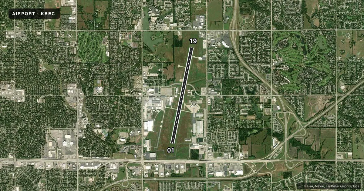
Runways & pattern
Full pagePattern entry · RWY 19
LEFT TRAFFICRunway end performance
| End | TORA | TODA | ASDA | LDA | VGSI | Approach lights | Obstruction |
|---|---|---|---|---|---|---|---|
| 01 | — | — | — | — | PAPI 4-box left(3°) | — | — |
| 19 | — | — | — | — | PAPI 4-box left(3°) | — | 35', trees, 1150' from thr, 360' R of cntrln, slope 27 |
Declared distances in feet. TORA = takeoff run available, TODA = takeoff distance, ASDA = accelerate-stop, LDA = landing distance.
Airport sketch
Runways drawn to scale from FAA survey coordinates, rendered over satellite imagery. Not for navigation.
Approaches & charts
Services on the field
Fuel grades, oxygen, maintenance, ramp storage and lighting — as declared to the FAA by the airport operator.
Fuel & services
- Fuel
- Not available
- Oxygen (bottled)
- Not available
- Airframe repair
- Not available
- Power plant repair
- Not available
Ramp & ground
- Transient storage
- Tie-down
- Landing fee
- No fee published
- Lighting schedule
- SEE RMK
- Beacon schedule
- SS-SR
- Beacon
- White / Green (civil land)(WG)
- Wind indicator
- Lighted
- Segmented circle
- Yes
Fuel & FBOs
Cheapest 100LL and Jet A on the field and nearby. Always confirm with the FBO before taxi.
Airport notes
Surface conditions, obstructions, local procedures, lighting outages and other notes published with each FAA cycle.
General notes
- ARR & DEP ACFT MAINTAIN 2200 FT MSL WITHIN 5 MILES OF FIELD DUE TO AFB TRAFFIC.
- ARRS FROM THE W CROSS MIDFIELD ENTER DNWND.
- DEER, COYOTE & MIGRATORY WATER FOWL ON & INVOF ARPT.
- PPR FOR PARKING OR TAXIING WEST SIDE OF RY.
- BE ALERT COL JAMES JABARA ARPT 3 MILES NORTH 1/2 MILE WEST OF ARPT.
- PRKG UNAVBL EXC 4 HRS PPR CALL 316-515-7140.
- EXTENSIVE TRAINING ACTIVITIES
- RWY 19 CALM WIND RWY.
Lighting notes
- WHEN ATCT CLSD ACTVT REIL RWY 01 AND 19; MIRL RWY 01/19 - CTAF.
Other notes
- EXISTED PRIOR TO 1959.
VFR map & nearby airports
VFR sectional. Tap any ICAO chip to open that airport.
Key facts · KBEC
Answer card- ICAO
- KBEC
- Name
- BEECH FACTORY
- Location
- WICHITA, KANSAS
- Elevation
- 1,408.6 ft MSL
- Traffic pattern altitude
- 2,408.6 ft MSL (1,000 AGL)
- Control tower
- Towered · 0700-1730 MON-FRI
- Total runways
- 1
- Longest runway
- 01/19 · 8,001 ft
- Published ILS approaches
- 0
- Published frequencies
- 9
- Magnetic variation
- 4°
- Current flight rules
- VFR
- Current wind
- 170° at 8 kt
- Favored runway now
- RWY 19
Beech Factory Airport (KBEC) sits in Wichita, Kansas. Field elevation is 1,408.6 ft MSL. The airport has one runway. Runway 01/19 is 8,001 ft of concrete, so there is plenty of pavement for most light aircraft and many business jets. The tower is open 0700-1730 Monday through Friday. No ILS approaches are published here, so plan with the current chart and your own arrival setup in mind.
Pattern altitude is not published. Use the standard 1,000 ft AGL for light piston traffic unless ATC or local procedures tell you otherwise. The field has no on-field FBOs listed in the facts, so verify services with the airport operator or call ahead before you go. Published remarks matter here. Parking is limited and requires prior permission, with a four-hour limit mentioned in the Chart Supplement. Aircraft arriving and departing must maintain 2,200 ft MSL within 5 miles of the field because of Air Force Base traffic. Expect heavy training activity. Runway 19 is the calm wind runway. When the tower is closed, use CTAF for runway end identifier lights and medium intensity runway lights on 01/19. Watch for Colonel James Jabara Airport just north and west of KBEC. Wildlife is also a factor here, including deer, coyote and migratory waterfowl.