METAR & TAF KBAK
Current METAR
Observed 12:45Z
KBAK 271245Z 00000KT 1SM BR OVC001 23/22 A2992
- Wind
- 000° @ 0 kt
- Visibility
- 1 SM
- Temp / Dew
- 23°C / 22°C
- Altimeter
- 29.92 inHg
- Clouds
- OVC
- Density alt
- 1,774 ft
- Ceiling
- 100 ft AGL
- Rules
- LIFR
Airport info & contacts
Manager on record, flight service, ARTCC, attendance schedule and pattern altitude — published by the FAA and refreshed every 28 days.
Location
- From city
- 3 NM N
- VFR sectional
- ST LOUIS
- ARTCC
- ZID · INDIANAPOLIS
- NOTAM facility
- BAK (NOTAM-D)
Airport manager
- Name
- BRIAN PAYNE
- Phone
- 812-376-2519
- Address
- 4770 RAY BOLL BLVD, COLUMBUS IN 47203
Flight service · Hours
- FSS HUF
- TERRE HAUTE1-800-WX-BRIEF
- Attendance
- SUN-THU
- FRI-SAT · 0600-2300
Frequencies
Tap any row to copy the frequency to your clipboard.
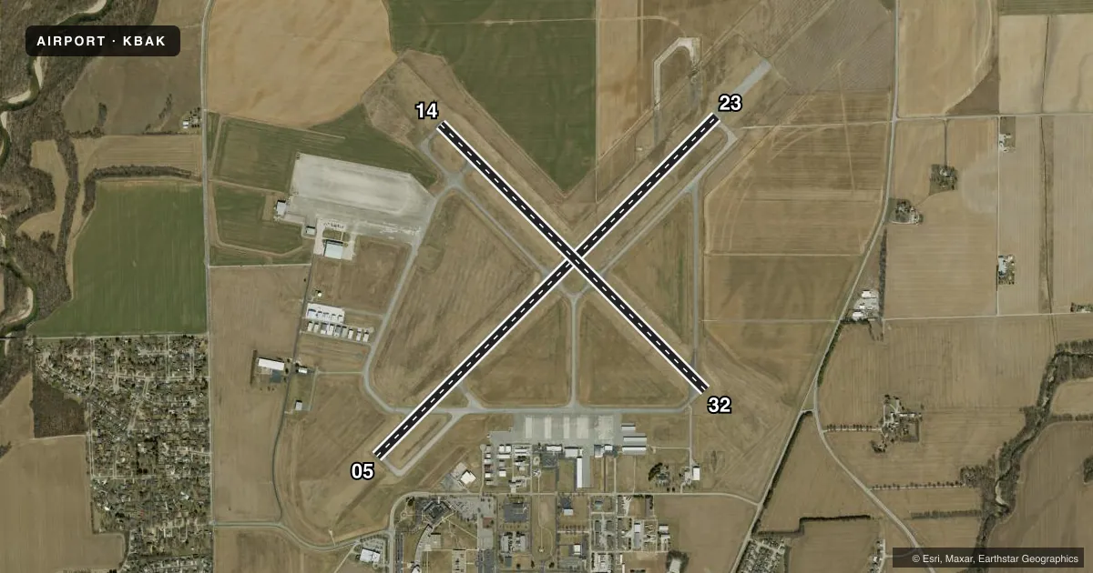
Runways & pattern
Full pagePattern entry · RWY 05
LEFT TRAFFIC| Runway | Heading (°M) | Length | Surface | Traffic |
|---|---|---|---|---|
| 05/23 | 42° / 222° | 6,401 ft | CONC | Standard L |
| 14/32 | 132° / 312° | 5,000 ft | CONC | Standard L |
Runway end performance
| End | TORA | TODA | ASDA | LDA | VGSI | Approach lights | Obstruction |
|---|---|---|---|---|---|---|---|
| 05 | 6,401' | 6,401' | 6,401' | 6,401' | PAPI 4-box left(3°) | — | 74', tower, 3040' from thr, 94' R of cntrln, slope 38 |
| 23 | 6,401' | 6,401' | 6,401' | 6,401' | PAPI 4-box left(3°) | MALSR | — |
| 14 | 5,000' | 5,000' | 5,000' | 5,000' | PAPI 4-box left(3°) | — | — |
| 32 | 5,000' | 5,000' | 5,000' | 5,000' | PAPI 4-box left(3°) | — | — |
Declared distances in feet. TORA = takeoff run available, TODA = takeoff distance, ASDA = accelerate-stop, LDA = landing distance.
Airport sketch
Runways drawn to scale from FAA survey coordinates, rendered over satellite imagery. Not for navigation.
Approaches & charts
ILS · 1
Services on the field
Fuel grades, oxygen, maintenance, ramp storage and lighting — as declared to the FAA by the airport operator.
Fuel & services
- Fuel
- 100LLA+
- Oxygen (bulk)
- HIGH/LOW
- Airframe repair
- Major
- Power plant repair
- Major
- Other services
- AFRT,AMB,AVNCS,CARGO,CHTR,INSTR,RNTL,SALES,SURV
Ramp & ground
- Transient storage
- Tie-down
- Hangar
- Landing fee
- No fee published
- Customs
- Not available
- Lighting schedule
- SEE RMK
- Beacon schedule
- SS-SR
- Beacon
- White / Green (civil land)(WG)
- Wind indicator
- Lighted
- Segmented circle
- No
Fuel & FBOs
Cheapest 100LL and Jet A on the field and nearby. Always confirm with the FBO before taxi.
Airport notes
Surface conditions, obstructions, local procedures, lighting outages and other notes published with each FAA cycle.
General notes
- SAWRS AVBL.
- BIRDS ON & INVOF ARPT; HVY ACT AUG & SEP.
- FICONS NOT MNTD 1700-0600.
- ACFT SVCS - UNICOM.
Lighting notes
- WHEN ATCT CLSD ACTVT MALSR RWY 23; REIL RWY 05, 14 & 32; HIRL RWY 05/23; MIRL RWY 14/32 - CTAF. PAPI RWY 5, 14, 23 & 32 ON CONSLY.
Runway surface & condition
- 05/23PCR VALUE: 320/R/A/W/T
- 14/32PCR VALUE: 300/R/A/W/T
- 05/23RWY 05/23 NOT AVBL FOR PART 121/PART 380 OPS WITH SKED PAX CARRYING OPS MORE THAN 9 PAX SEATS AND NON-SKED PAX CARRYING OPS MORE THAN 30 PAX SEATS. 90 DAY PPR FOR UNSKED ACR OPS GTR THAN 30 PAX SEATS - CALL AMGR. 812-376-2519 OR 379-9942. MIL MARKINGS CMSND.
- 14/32RWY 14/32 NOT AVBL FOR PART 121/PART 380 OPS WITH SKED PAX CARRYING OPS MORE THAN 9 PAX SEATS AND NON-SKED PAX CARRYING OPS MORE THAN 30 PAX SEATS. 90 DAY PPR FOR UNSKED ACR OPS GTR THAN 30 PAX SEATS - CALL AMGR. 812-376-2519 OR 379-9942.
Other notes
- 1AFT HR - 812-372-1819.
- MANAGER812-379-9942
VFR map & nearby airports
VFR sectional. Tap any ICAO chip to open that airport.
Key facts · KBAK
Answer card- ICAO
- KBAK
- Name
- COLUMBUS MUNI
- Location
- COLUMBUS, INDIANA
- Elevation
- 656.1 ft MSL
- Traffic pattern altitude
- 1,656.1 ft MSL (1,000 AGL)
- Control tower
- Towered · 0630-2200
- Total runways
- 2
- Longest runway
- 05/23 · 6,401 ft
- Published ILS approaches
- 1
- Published frequencies
- 7
- Magnetic variation
- 3°
- Current flight rules
- LIFR
- Current wind
- 000° at 0 kt
- Favored runway now
- –
Columbus Muni is in Columbus, Indiana. The field elevation is 656.1 ft MSL. It has two concrete runways. The longest is runway 05/23 at 6,401 ft. The airport is towered from 0630 to 2200. Runway 23 has the ILS approach. Pattern altitude is not published, so use 1,000 ft AGL for light piston operations unless the current Chart Supplement says otherwise.
Two on-field FBOs are listed. Columbus Municipal Airport carries 100LL. Jet Access carries 100LL and Jet A with Prist. If you need current ramp or service details, call the FBO directly before departure. The airport manager can also be reached at 812-379-9942. Published remarks note that aircraft services are available via UNICOM. They also note bird activity on and near the airport, with heavier activity in August and September.
For a first-time arrival, the main things to plan for are the towered environment, the single ILS to runway 23 and the bird hazard in late summer. The field also has runway lighting procedures for when the tower is closed. Check the current Chart Supplement for any noise or curfew restrictions before flying into the field.