METAR & TAF KBAF
Current METAR
Observed 16:53Z
KBAF 271653Z 23004KT 10SM FEW046 27/16 A2983 RMK AO2 LTG DSNT SW AND NW SLP098 T02720156
- Wind
- 230° @ 4 kt
- Visibility
- 10 SM
- Temp / Dew
- 27°C / 16°C
- Altimeter
- 29.83 inHg
- Clouds
- FEW
- Density alt
- 1,886 ft
- Ceiling
- Unlimited
- Rules
- VFR
Airport info & contacts
Manager on record, flight service, ARTCC, attendance schedule and pattern altitude — published by the FAA and refreshed every 28 days.
Location
- From city
- 3 NM N
- VFR sectional
- NEW YORK
- Pattern altitude
- 1,029 ft AGL · 1,299 ft MSL
- ARTCC
- ZBW · BOSTON
- NOTAM facility
- BAF (NOTAM-D)
Airport manager
- Name
- DANIEL SHEARER
- Phone
- 413-572-6275
- Address
- 110 AIRPORT RD, WESTFIELD MA 01085
Flight service · Hours
- FSS BTV
- BURLINGTON1-800-WX-BRIEF
- Attendance
- 0700-1900 LOCAL
Frequencies
Tap any row to copy the frequency to your clipboard.
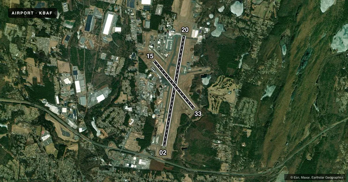
Runways & pattern
Full pagePattern entry · RWY 20
LEFT TRAFFIC| Runway | Heading (°M) | Length | Surface | Traffic |
|---|---|---|---|---|
| 02/20Favored | 356° / 176° | 9,000 ft | ASPH | Standard L |
| 15/33 | 126° / 306° | 5,000 ft | ASPH | Standard L |
Runway end performance
| End | TORA | TODA | ASDA | LDA | VGSI | Approach lights | Obstruction |
|---|---|---|---|---|---|---|---|
| 02 | 9,000' | 9,000' | 9,000' | 9,000' | PAPI 4-box left(3°) | — | 56', trees, 1325' from thr, 300' R of cntrln, slope 20 |
| 20 | 9,000' | 9,000' | 8,919' | 8,919' | PAPI 4-box left(3°) | MALSR | 83', trees, 2950' from thr, 175' R of cntrln, slope 33 |
| 15 | 5,000' | 5,000' | 4,508' | 4,510' | PAPI 4-box left(3.5°) | — | 48', trees, 1150' from thr, 35' R of cntrln, slope 19 |
| 33 | 5,000' | 5,000' | 5,000' | 5,000' | PAPI 4-box left(4°) | — | 30', trees, 150' from thr, 0' R of cntrln, slope 1 |
Declared distances in feet. TORA = takeoff run available, TODA = takeoff distance, ASDA = accelerate-stop, LDA = landing distance.
Airport sketch
Runways drawn to scale from FAA survey coordinates, rendered over satellite imagery. Not for navigation.
Approaches & charts
ILS · 1
Services on the field
Fuel grades, oxygen, maintenance, ramp storage and lighting — as declared to the FAA by the airport operator.
Fuel & services
- Fuel
- 100LLA
- Oxygen (bottled)
- Not available
- Oxygen (bulk)
- HIGH/LOW
- Airframe repair
- Major
- Power plant repair
- Major
- Other services
- AFRT,CHTR,INSTR,RNTL,SALES
Ramp & ground
- Transient storage
- Tie-down
- Hangar
- Landing fee
- Yes
- Customs
- Not available
- Lighting schedule
- SEE RMK
- Beacon schedule
- SS-SR
- Beacon
- White / Green (civil land)(WG)
- Wind indicator
- Lighted
- Segmented circle
- Yes
Fuel & FBOs
Cheapest 100LL and Jet A on the field and nearby. Always confirm with the FBO before taxi.
Airport notes
Surface conditions, obstructions, local procedures, lighting outages and other notes published with each FAA cycle.
General notes
- MILITARY: ANG: BASH II COND JUL & AUG FOR MIGRATORY BIRD ACT.
- FOR CD WHEN ATCT CLSD, CTC BRADLEY APCH AT 860-386-3597.
- JET ACFT STARTING UNITS AVBL.
- SVR DOWNDRAFT AER 33 WHEN WIND NW IN EXCESS OF 15 KT. BIRDS & OTHER WILDLIFE ON & INVOF ARPT.
- TWY G CLSD TO CIV OPS.
- ACFT & HEL NOISE ABATEMENT PROCS IN EFCT - AMGR.
- MILITARY: ANG: OPR 1200-2200Z++ TUE-FRI EXC HOL. LTD COPTER MAINT, FUEL AND ACFT PRK ARNG RAMP. NO COPTER LDG OR DEP FR PRK RAMP. CTC DSN 698-1811 OR C413-568-9151 EXTN 1811.
- MILITARY: ANG: ALL TRAN ACFT MUST OBTAIN PPR NR 48 HR PRIOR; CTC C413-568-9151 EXTN 698-1228/9 OR DSN 698-1228/9. OFFL BUS 1230-2200Z++ TUE-FRI, CLSD HOL. NO DE-ICING AVBL. FOR CURRENT BIRD WATCH COND CTC HAWK OPS 309.0; DURG NON-DUTY HR CTC WHIP ON 309.0. BASH PHASE II COND, JUL, AUG AND SEP FOR MIGRATORY BIRD ACT.
- CSTMS/AG/IMG - 1300-2300Z++ MON-FRI, FONE PRIOR 2300Z++ PRECEDING WKD C413-785-0365, C800-973-2867.
- MISC - FIRST 400 FT RWY 02/20 CONC, MID 8200 FT ASPH. RWY 02/20 GROOVED. CLASS D ASP EFF 1200-0300Z++, OT CLASS G. LDG FEE COML, CORPORATE AND ALL ACFT OVER 5000 LB. FLT NOTIFICATION SVC, ADCUS, AVBL. LAWRS.
- BE AWARE WING TIP CLRNC S RUNUP/D-ARM PAD TWY CNTRLN MKGS FOR F-15 A/C ONLY.
- SERVICE-A-GEAR: REQ THRU TWR DUR TWR OPR HR, WHEN TWR CLSD REQ THRU ANG CP, WHIP ON UHF 309.0. RWY 02/20, MIL ACFT ARST BARRIERS MAY FAIL IN THE UP POSN. VERIFY STATUS OF BARRIERS PRIOR TO LDG. HVY ACFT SHOULD AVOID LDG DRCTLY ON ARST BARRIER. RWY GROOVING FOR SFC DRAINAGE WI 10 FT N & S OF BOTH ARST SYSS.
- MILITARY: ANG: NO ACFT WITH WINGSPAN GREATER THAN 110 FT ALLOWED ON ANG RAMP. NSTD TXL CNTRLN MRKG LEADING INTO ANG APN.
- RWY 2/20 MIL ACFT ARST BARRIERS MAY FAIL IN THE UP PSN. SML GA ACFT SHOULD USE CTN, SPCLY AT NGT, AND IF POSS CFM THE ACTUAL STS OF THE BARRIERS PRIOR TO LDG.
- COLD TEMPERATURE AIRPORT. ALTITUDE CORRECTION REQUIRED AT OR BELOW -20C.
Lighting notes
- WHEN ATCT CLSD ACTVT MALSR RWY 20; REIL RWY 02; PAPI RWY 15; HIRL RWY 02/20; MIRL RWY 15/33 - CTAF. PAPI RWY 33 - CONSLY.
Runway surface & condition
- 02/20PCR VALUE: 460/R/C/W/T
- 15/33PCR VALUE: 600/F/A/X/T
- 15/33RWY 15/33 NOT AVBL FOR PART 121/PART 380 OPS WITH SKED PAX CARRYING OPS MORE THAN 9 PAX SEATS AND NON-SKED PAX CARRYING OPS MORE THAN 30 PAX SEATS.
- 02/20200 FT OVRN NE END & SW END.
Approach & departure obstructions
- 15UNUSBL BYD 4 NM.
Arresting gear
- 20_BAK-14BAK-14 BAK-12B(B) (1450 FT).
- 02_BAK-14BAK-14 BAK-12B(B) (1420 FT).
Other notes
- PPR 24 HR FOR ACR OPS WITH MORE THAN 9 PAX - AMGR.
- FEE FOR COML; CORPORATE; ACFT OVR 7500 LBS.
- TPA 1300 (1029) LGT ACFT; 1800 (1529) HVY & MIL ACFT. EXPC MIL OVHD & CLSD PAT TFC.
- 1FUEL AVBL 0700-1900; SVC AFT 1900 PPR - 413-485-0078.
VFR map & nearby airports
VFR sectional. Tap any ICAO chip to open that airport.
Key facts · KBAF
Answer card- ICAO
- KBAF
- Name
- WESTFIELD-BARNES RGNL
- Location
- WESTFIELD/SPRINGFIELD, MASSACHUSETTS
- Elevation
- 270 ft MSL
- Traffic pattern altitude
- 1,299 ft MSL (1,029 AGL)
- Control tower
- Towered · 0700-2200
- Total runways
- 2
- Longest runway
- 02/20 · 9,000 ft
- Published ILS approaches
- 1
- Published frequencies
- 13
- Magnetic variation
- 14°
- Current flight rules
- VFR
- Current wind
- 230° at 4 kt
- Favored runway now
- RWY 20
Westfield-Barnes Rgnl sits in Westfield and Springfield, Massachusetts. Field elevation is 270 ft MSL. The airport has two asphalt runways. The longest is runway 02/20 at 9,000 ft. Runway 15/33 is 5,000 ft. The tower is open daily from 0700 to 2200. Runway 20 has the published ILS approach. Pattern altitude is 1,299 ft MSL. That is 1,029 ft AGL.
Atlantic Aviation is on the field. It carries 100LL and Jet A. Fuel is available from 0700 to 1900. After 1900, service is by prior permission through the FBO.
A few items matter here. Taxiway G is closed to civilian operations. Noise abatement procedures are in effect as directed by the airport manager. Class D airspace is effective from 1200 to 0300 Zulu. Outside those hours, Class G applies. Runway 02/20 is grooved. The first 400 ft is concrete. The rest is asphalt. The airport also publishes caution about severe downdraft near runway 33 when northwest winds are above 15 knots. Birds and other wildlife are also present. If you are planning a night arrival or a heavy aircraft arrival, check the current Chart Supplement and brief the runway 02/20 arresting barrier status before you go.