METAR & TAF KAZO
Current METAR
Observed 14:53Z
KAZO 271453Z 21008KT 10SM SCT100 24/21 A2987 RMK AO2 LTG DSNT E RAE1354 SLP110 P0000 60003 T02440211 56007
- Wind
- 210° @ 8 kt
- Visibility
- 10 SM
- Temp / Dew
- 24°C / 21°C
- Altimeter
- 29.87 inHg
- Clouds
- SCT
- Density alt
- 2,226 ft
- Ceiling
- Unlimited
- Rules
- VFR
Airport info & contacts
Manager on record, flight service, ARTCC, attendance schedule and pattern altitude — published by the FAA and refreshed every 28 days.
Location
- From city
- 3 NM SE
- VFR sectional
- CHICAGO
- Pattern altitude
- 800 ft AGL · 1,674 ft MSL
- ARTCC
- ZAU · CHICAGO
- NOTAM facility
- AZO (NOTAM-D)
Airport manager
- Name
- CRAIG WILLIAMS, AIRPORT DIRECTOR
- Phone
- 269-388-3668
- Address
- 5235 PORTAGE RD, PORTAGE MI 49002
Flight service · Hours
- FSS LAN
- LANSING1-800-WX-BRIEF
- Attendance
- ALL
Frequencies
Tap any row to copy the frequency to your clipboard.
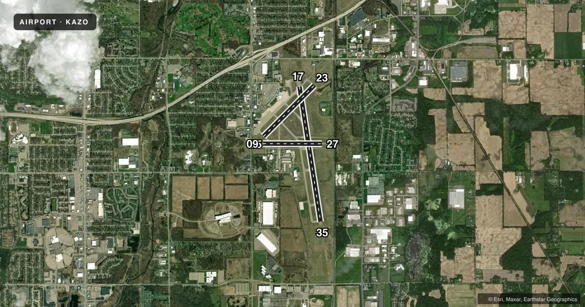
Runways & pattern
Full pagePattern entry · RWY 23
LEFT TRAFFIC| Runway | Heading (°M) | Length | Surface | Traffic |
|---|---|---|---|---|
| 17/35 | 168° / 348° | 6,502 ft | ASPH | Standard L |
| 05/23Favored | 42° / 222° | 3,438 ft | ASPH | Standard L |
| 09/27 | 87° / 267° | 2,800 ft | ASPH | Standard L |
Runway end performance
| End | TORA | TODA | ASDA | LDA | VGSI | Approach lights | Obstruction |
|---|---|---|---|---|---|---|---|
| 17 | 6,502' | 6,502' | 6,502' | 6,502' | PAPI 4-box left(3°) | — | 76', trees, 2090' from thr, 750' R of cntrln, slope 24 |
| 35 | 6,502' | 6,502' | 6,502' | 6,502' | PAPI 4-box left(3°) | MALSR | 18', rr, 758' from thr, 586' R of cntrln, slope 31 |
| 05 | 3,438' | 3,438' | 3,438' | 3,438' | PAPI 4-box left(3°) | — | 46', pole, 900' from thr, 275' R of cntrln, slope 15 |
| 23 | 3,438' | 3,438' | 3,438' | 3,438' | PAPI 4-box left(3.5°) | — | 53', tree, 1050' from thr, 340' R of cntrln, slope 16 |
| 09 | 2,800' | 2,800' | 2,800' | 2,800' | — | — | 84', tree, 1710' from thr, 275' R of cntrln, slope 17 |
| 27 | 2,800' | 2,800' | 2,800' | 2,800' | — | — | 17', rr, 640' from thr, 0' R of cntrln, slope 25 |
Declared distances in feet. TORA = takeoff run available, TODA = takeoff distance, ASDA = accelerate-stop, LDA = landing distance.
Airport sketch
Runways drawn to scale from FAA survey coordinates, rendered over satellite imagery. Not for navigation.
Approaches & charts
ILS · 1
Services on the field
Fuel grades, oxygen, maintenance, ramp storage and lighting — as declared to the FAA by the airport operator.
Fuel & services
- Fuel
- 100LLA
- Oxygen (bottled)
- High pressure
- Oxygen (bulk)
- High pressure
- Airframe repair
- Major
- Power plant repair
- Major
- Other services
- CARGO,CHTR,INSTR,RNTL
Ramp & ground
- Transient storage
- Tie-down
- Hangar
- Landing fee
- Yes
- Customs
- Not available
- Lighting schedule
- SEE RMK
- Beacon schedule
- SEE RMK
- Beacon
- White / Green (civil land)(WG)
- Wind indicator
- Lighted
- Segmented circle
- Yes
Fuel & FBOs
Cheapest 100LL and Jet A on the field and nearby. Always confirm with the FBO before taxi.
Airport notes
Surface conditions, obstructions, local procedures, lighting outages and other notes published with each FAA cycle.
General notes
- MIGRATORY WATER FOWL ROOSTING AREA 5500 FT APCH END RY 35. BIRDS ON & INVOF ARPT.
- FOR CUSTOMS CALL 269-965-3349.
- TWYS F & G E OF RY 17/35 RSTRD ACFT LESS THAN 12500 LBS.
- RY 09 & RY 05 APCH ENDS ARE CLOSELY ALIGNED. VERIFY CORRECT RY AND COMPASS HEADING PRIOR TO DEP.
- FOR CD WHEN TWR CLSD CTC GREAT LAKES APCH AT 269-459-3344, WHEN APCH CLSD CTC CHICAGO ARTCC AT 630-906-8921.
- 11C SPB LCTD 3.6 NM SOUTH. ACFT OPRG AT 11C WILL ANNC INTNS ON AZO CTAF.
- PPR FOR UNSKED ACR OPS GTR THAN 175,000 LB MAX TOG.
- FICONS UNMON NOV-APR 0000-0300 & MAY-OCT 0000-0400.
Lighting notes
- ATC-CTL
- WHEN ATCT CLSD ACTVT MALSR RWY 35; REIL RWY 17, 05, & 23; HIRL RWY 17/35; MIRL RWY 05/23 & 09/27 - CTAF. PAPI RWY 17, 35, 05, & 23 OPR CONSLY.
Runway surface & condition
- 05/23PCR VALUE: 354/F/C/X/T
- 09/27PCR VALUE: 66/F/C/X/T
- 17/35PCR VALUE: 402/F/C/X/T
- 05/23RWY 05/23 NOT AVBL FOR PART 121/PART 380 OPS WITH SKED PAX CARRYING OPS MORE THAN 9 PAX SEATS AND NON-SKED PAX CARRYING OPS MORE THAN 30 PAX SEATS. NO PART 121/PART 380 OPS EXC FOR TAX.
- 09/27RWY 09/27 NOT AVBL FOR PART 121/PART 380 OPS WITH SKED PAX CARRYING OPS MORE THAN 9 PAX SEATS AND NON-SKED PAX CARRYING OPS MORE THAN 30 PAX SEATS.
Other notes
- PPR FOR UNSKED ACR OPS GTR THAN 30 PAX SEATS - CALL AMGR.
- GA LDG FEE FOR ACFT WITH MAX LDG WT 8000 LB OR GTR.
VFR map & nearby airports
VFR sectional. Tap any ICAO chip to open that airport.
Key facts · KAZO
Answer card- ICAO
- KAZO
- Name
- KALAMAZOO/BATTLE CREEK INTL
- Location
- KALAMAZOO, MICHIGAN
- Elevation
- 873.9 ft MSL
- Traffic pattern altitude
- 1,673.9 ft MSL (800 AGL)
- Control tower
- Towered · 0600-2300
- Total runways
- 3
- Longest runway
- 17/35 · 6,502 ft
- Published ILS approaches
- 1
- Published frequencies
- 18
- Magnetic variation
- 3°
- Current flight rules
- VFR
- Current wind
- 210° at 8 kt
- Favored runway now
- RWY 23
Kalamazoo/Battle Creek Intl sits in Kalamazoo, Michigan. Field elevation is 873.9 ft MSL. The airport has three asphalt runways. The longest is runway 17/35 at 6,502 ft. The field is towered from 0600 to 2300. There is one ILS approach. It serves runway 35.
Pattern altitude is 800 ft AGL, which is 1,673.9 ft MSL. That lower pattern height matters here because the airport sits in a busy part of southwest Michigan with controlled traffic and mixed GA and airline use. The published remarks also call out birds near the airport. Migratory waterfowl roost near the approach end of runway 35, so expect to stay alert on arrival and departure. Runway 09 and runway 05 approach ends are closely aligned. Verify the correct runway and heading before you roll.
On the field, Kalamazoo Pilots Association carries AVGAS 100LL. Duncan Aviation carries AVGAS 100LL, JET A and JET A Prist. The airport also publishes a general aviation landing fee for aircraft with maximum landing weight of 8,000 pounds or greater. If you need current operating details, check the current FAA Chart Supplement or call the airport operator or FBO directly. The tower lighting schedule is published, so night ops should be briefed before you go.