METAR & TAF KAUS
Current METAR
Observed 07:53Z
KAUS 280753Z 18008KT 10SM OVC016 26/23 A2989 RMK AO2 SLP110 T02560233
- Wind
- 180° @ 8 kt
- Visibility
- 10 SM
- Temp / Dew
- 26°C / 23°C
- Altimeter
- 29.89 inHg
- Clouds
- OVC
- Density alt
- 2,029 ft
- Ceiling
- 1,600 ft AGL
- Rules
- MVFR
Airport info & contacts
Manager on record, flight service, ARTCC, attendance schedule and pattern altitude — published by the FAA and refreshed every 28 days.
Location
- From city
- 5 NM SE
- VFR sectional
- SAN ANTONIO
- ARTCC
- ZHU · HOUSTON
- NOTAM facility
- AUS (NOTAM-D)
Airport manager
- Name
- GHIZLANE BADAWI
- Phone
- 512-530-8846
- Address
- 3600 PRESIDENTIAL BLVD, SUITE 411, AUSTIN TX 78719
Flight service · Hours
- FSS SJT
- SAN ANGELO1-800-WX-BRIEF
- Attendance
- ALL
Frequencies
Tap any row to copy the frequency to your clipboard.
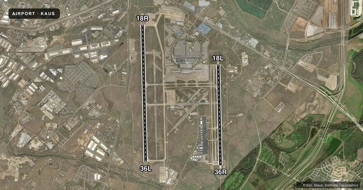
Runways & pattern
Full pagePattern entry · RWY 18R
RIGHT TRAFFIC| Runway | Heading (°M) | Length | Surface | Traffic |
|---|---|---|---|---|
| 18R/36LFavored | 175° / 355° | 12,250 ft | CONC | 18R R |
| 18L/36R | 175° / 355° | 9,000 ft | CONC | 36R R |
Runway end performance
| End | TORA | TODA | ASDA | LDA | VGSI | Approach lights | Obstruction |
|---|---|---|---|---|---|---|---|
| 18R | 12,250' | 12,250' | 12,250' | 12,250' | PAPI 4-box left(3°) | MALS | — |
| 36L | 12,250' | 12,250' | 12,250' | 12,250' | PAPI 4-box left(3°) | MALS | — |
| 18L | 9,000' | 9,000' | 9,000' | 9,000' | PAPI 4-box left(3°) | ALSF2 | 90', tower, 3807' from thr, 236' R of cntrln, slope 40 |
| 36R | 9,000' | 9,000' | 9,000' | 9,000' | PAPI 4-box left(3°) | MALSR | — |
Declared distances in feet. TORA = takeoff run available, TODA = takeoff distance, ASDA = accelerate-stop, LDA = landing distance.
Airport sketch
Runways drawn to scale from FAA survey coordinates, rendered over satellite imagery. Not for navigation.
Approaches & charts
ILS · 4
Services on the field
Fuel grades, oxygen, maintenance, ramp storage and lighting — as declared to the FAA by the airport operator.
Fuel & services
- Fuel
- 100LLA
- Oxygen (bottled)
- HIGH/LOW
- Airframe repair
- Minor
- Power plant repair
- Minor
- Other services
- AFRT,AVNCS,CARGO,CHTR,INSTR,RNTL,SALES
Ramp & ground
- Transient storage
- Tie-down
- Hangar
- Landing fee
- No fee published
- Lighting schedule
- SS-SR
- Beacon schedule
- SS-SR
- Beacon
- White / Green (civil land)(WG)
- Wind indicator
- Lighted
- Segmented circle
- No
Fuel & FBOs
Cheapest 100LL and Jet A on the field and nearby. Always confirm with the FBO before taxi.
Airport notes
Surface conditions, obstructions, local procedures, lighting outages and other notes published with each FAA cycle.
General notes
- BIRD ACTIVITY ON & INVOF ARPT.
- DURG THE HRS 0000-0600 ARRG ACFT WILL BE ASGND RWY 36L OR RWY 36R & DEPARTING ACFT WILL BE ASGND RWY 18L OR RWY 18R TO AVOID NOISE SENSITIVE AREAS.
- NOISE ABATEMENT: ALL DEP FOLLOW ATC INSTRUCTIONS; CLIMB ASAP TO 4000 FT OR ABOVE.
- PPR ENGINE MAINTENANCE RUN UPS CALL OPS 512-530-7550.
- PPR GA ACFT ON THE PSGR TERMINAL APRON, CALL OPS 512-530-7550.
- ARNG: OPR 1300-2300++ TUE-FRI, DSN 954-5001 EXT 7024614, C512-356-7900 EXT 7024614.
- TWY A CLSD TO ACFT WITH WINGSPAN MORE THAN 171 FT.
- PPR FOR NON STATE OF TEXAS AIRCRAFT ENTERING THE STATE RAMP ABEAM TWY E. CALL STATE OPS 512-936-8900 OR FREQ. 131.375.
- TXLN R4 CLSD TO AFCT WITH WINGSPAN MORE THAN 135.
- TXLN C2 CLSD TO AFCT WITH WINGSPAN MORE THAN 171.
- TXLN R1, R3, R5 CLSD TO AFCT WITH WINGSPAN MORE THAN 118.
- TXLN C2 BTWN TWY C AND G1, AND TXLN R1 CLSD 2000L-0800L.
- CTC RAMP CTL AT 126.225 PRIOR TO ENTRY/EXIT TO/FM THE TRML APN.
Runway surface & condition
- 18L/36RPCR VALUE: 900/R/B/W/T
- 18R/36LPCR VALUE: 1070/R/B/W/T
Other notes
- MANAGERGHIZLANE.BADAWI@FLYAUSTIN.COM
VFR map & nearby airports
VFR sectional. Tap any ICAO chip to open that airport.
Key facts · KAUS
Answer card- ICAO
- KAUS
- Name
- AUSTIN-BERGSTROM INTL
- Location
- AUSTIN, TEXAS
- Elevation
- 541.5 ft MSL
- Traffic pattern altitude
- 1,541.5 ft MSL (1,000 AGL)
- Control tower
- Towered · 24
- Total runways
- 2
- Longest runway
- 18R/36L · 12,250 ft
- Published ILS approaches
- 4
- Published frequencies
- 28
- Magnetic variation
- 4°
- Current flight rules
- MVFR
- Current wind
- 180° at 8 kt
- Favored runway now
- RWY 18R
KAUS is Austin-Bergstrom Intl in Austin, Texas. The field elevation is 541.5 ft MSL. It has two concrete runways. The longest is 18R/36L at 12,250 ft. The tower is open 24 hours. Four ILS approaches are published for the four runway ends. Pattern altitude is not published in the facts, so use the standard 1,000 ft AGL for light piston traffic. Verify the current Chart Supplement before you go.
This is a Class C airport with busy airline and GA traffic. Bird activity is reported on and near the field, so keep a sharp scan on taxi, takeoff and final. Noise abatement is active. Departures are expected to follow ATC instructions. They should climb as soon as possible to 4,000 ft or above. During 0000 to 0600, arranged aircraft are assigned runway 36L or 36R. Departing aircraft are assigned runway 18L or 18R to help avoid noise sensitive areas. Taxiway C2 between taxiway C and G1, plus taxiway R1, are closed from 2000 local time to 0800 local time. On the field, Million Air carries 100LL, Jet A and Jet A Prist. Signature Aviation carries 100LL and Jet A. Atlantic Aviation carries 100LL and Jet A. Ramp control is required before entry or exit to the terminal apron. GA aircraft need prior permission for the passenger terminal apron, engine run-ups and some State ramp access.