METAR & TAF PASM
Current METAR
Observed 08:56Z
PASM 280856Z AUTO 20004KT 10SM OVC032 10/07 A3003 RMK AO2 SLP177 T01000072 53009
- Wind
- 200° @ 4 kt
- Visibility
- 10 SM
- Temp / Dew
- 10°C / 7°C
- Altimeter
- 30.03 inHg
- Clouds
- OVC
- Density alt
- -347 ft
- Ceiling
- 3,200 ft AGL
- Rules
- VFR
Airport info & contacts
Manager on record, flight service, ARTCC, attendance schedule and pattern altitude — published by the FAA and refreshed every 28 days.
Location
- From city
- 4 NM W
- VFR sectional
- BETHEL
- ARTCC
- ZAN · ANCHORAGE
- NOTAM facility
- KSM (NOTAM-D)
Airport manager
- Name
- ERIK WEINGARTH
- Phone
- 907-438-2416
- Address
- PO BOX 135, ST MARY'S AK 99658
Flight service · Hours
- FSS ENA
- KENAI907-283-72111-866-864-1737
- Attendance
- WINTER · 0700-1530
- SUMMER · MON-FRI · 0700-1530
Frequencies
Tap any row to copy the frequency to your clipboard.
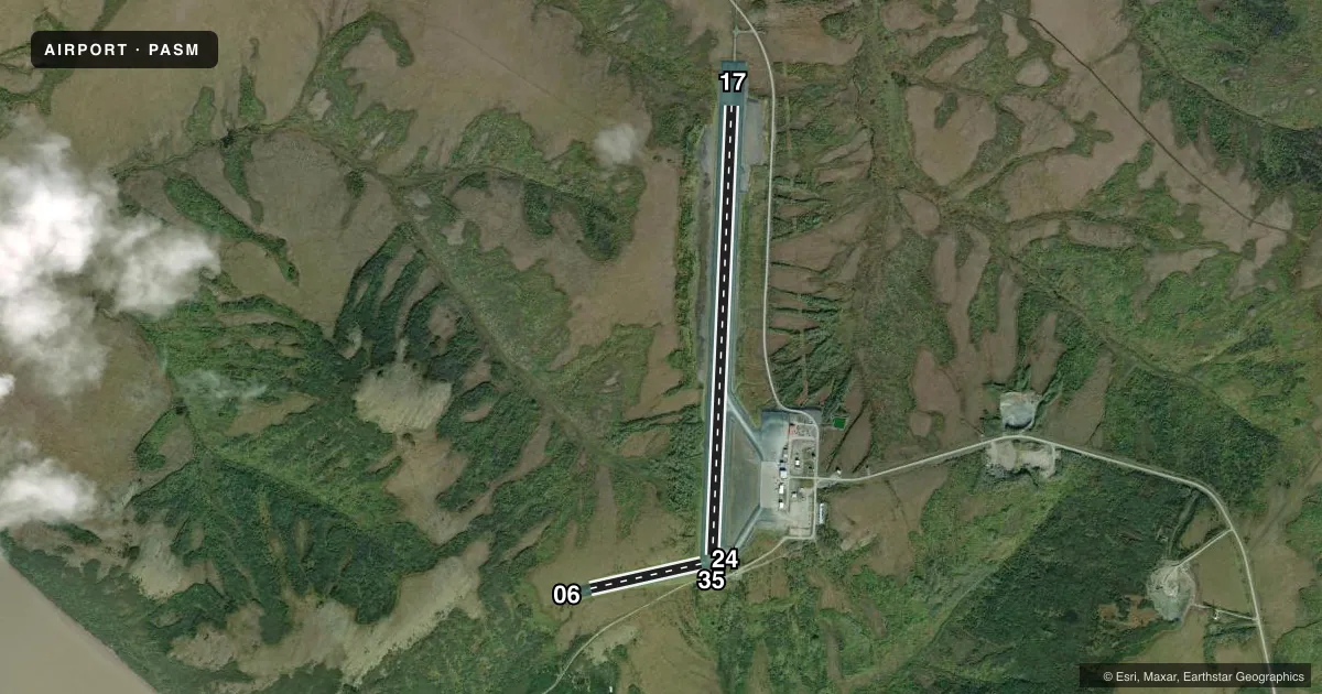
Runways & pattern
Full pagePattern entry · RWY 17
LEFT TRAFFIC| Runway | Heading (°M) | Length | Surface | Traffic |
|---|---|---|---|---|
| 17/35Favored | 170° / 350° | 6,008 ft | GRAVEL | Standard L |
| 06/24 | 65° / 245° | 1,520 ft | GRAVEL | Standard L |
Runway end performance
| End | TORA | TODA | ASDA | LDA | VGSI | Approach lights | Obstruction |
|---|---|---|---|---|---|---|---|
| 17 | — | — | — | — | PAPI 4-box left(3°) | — | — |
| 35 | — | — | — | — | PAPI 4-box left(3°) | — | — |
| 06 | — | — | — | — | — | — | 145', hill, 3480' from thr, 0' R of cntrln, slope 24 |
| 24 | — | — | — | — | — | — | 100', hill, 5000' from thr, 0' R of cntrln, slope 50 |
Declared distances in feet. TORA = takeoff run available, TODA = takeoff distance, ASDA = accelerate-stop, LDA = landing distance.
Airport sketch
Runways drawn to scale from FAA survey coordinates, rendered over satellite imagery. Not for navigation.
Approaches & charts
ILS · 1
Services on the field
Fuel grades, oxygen, maintenance, ramp storage and lighting — as declared to the FAA by the airport operator.
Fuel & services
- Fuel
- Not available
- Other services
- CARGO
Ramp & ground
- Transient storage
- Tie-down
- Landing fee
- No fee published
- Customs
- Not available
- Lighting schedule
- SEE RMK
- Beacon schedule
- SS-SR
- Beacon
- White / Green (civil land)(WG)
- Wind indicator
- Yes
- Segmented circle
- Yes
Fuel & FBOs
Cheapest 100LL and Jet A on the field and nearby. Always confirm with the FBO before taxi.
Airport notes
Surface conditions, obstructions, local procedures, lighting outages and other notes published with each FAA cycle.
General notes
- SNOW & ICE REMOVAL & HAZ RPRTG DURG DURING DUTY HR; AFT HR PPR IN WRITING - AMGR.
- PSBL RWY DRIFTING SNOW & POOR BRAKING; COND RPRT DALGT OPS ONLY.
- CLSD TO OPS RQRG PAX SCREENING.
- WX CAMERA AVBL ON INTERNET AT HTTPS://WEATHERCAMS.FAA.GOV
Lighting notes
- ACTVT REIL RWY 17 & 35; PAPI RWY 17 & 35; HIRL RWY 17/35; MIRL RWY 06/24 - CTAF.
VFR map & nearby airports
VFR sectional. Tap any ICAO chip to open that airport.
Key facts · PASM
Answer card- ICAO
- PASM
- Name
- ST MARY'S
- Location
- ST MARY'S, ALASKA
- Elevation
- 314.1 ft MSL
- Traffic pattern altitude
- 1,314.1 ft MSL (1,000 AGL)
- Control tower
- Non-towered (use CTAF)
- Total runways
- 2
- Longest runway
- 17/35 · 6,008 ft
- Published ILS approaches
- 1
- Published frequencies
- 1
- Magnetic variation
- 12°
- Current flight rules
- VFR
- Current wind
- 200° at 4 kt
- Favored runway now
- RWY 17
St Mary's Airport sits in St Mary's, Alaska. Field elevation is 314.1 ft MSL. The airport has two gravel runways. The longest is 6,008 ft on runway 17/35. This is an uncontrolled field. CTAF is 122.3.
The published ILS is for runway 17. Pattern altitude is not published, so use standard 1,000 ft AGL for light piston operations unless the current Chart Supplement says otherwise. Crowley Aviation Fuels is on the field. They carry 100LL and Jet A. Call (907) 438-2593 for current service details before you go.
Plan for Alaska weather and runway condition changes. Published remarks call out possible drifting snow and poor braking. Condition reports are only during daylight operations. Snow and ice removal plus hazard reporting happen during duty hours. After hours, prior permission in writing from the airport manager is required. Runway lighting is available on both runways. Runway 17/35 has high intensity lights, REILs and PAPI. Runway 06/24 has medium intensity lights. The airport is closed to operations that require passenger screening. Check the current FAA Chart Supplement before departure for any updates on runway condition, lighting use, or operational limits.