METAR & TAF PADM
Current METAR
Observed 06:56Z
PADM 280656Z AUTO 23007KT 10SM OVC032 11/08 A3004 RMK AO2 SLP179 T01110078 PNO $
- Wind
- 230° @ 7 kt
- Visibility
- 10 SM
- Temp / Dew
- 11°C / 8°C
- Altimeter
- 30.04 inHg
- Clouds
- OVC
- Density alt
- -486 ft
- Ceiling
- 3,200 ft AGL
- Rules
- VFR
Airport info & contacts
Manager on record, flight service, ARTCC, attendance schedule and pattern altitude — published by the FAA and refreshed every 28 days.
Location
- From city
- 2 NM SE
- VFR sectional
- BETHEL
- ARTCC
- ZAN · ANCHORAGE
- NOTAM facility
- MDM (NOTAM-D)
Airport manager
- Name
- ERIK WEINGARTH
- Phone
- 907-438-2416
- Address
- PO BOX 135, ST MARY'S AK 99658
Flight service · Hours
- FSS ENA
- KENAI907-283-72111-866-864-1737
- Attendance
- Unattended
Frequencies
Tap any row to copy the frequency to your clipboard.
Runways & pattern
Full pagePattern entry · RWY 25
LEFT TRAFFICRunway end performance
| End | TORA | TODA | ASDA | LDA | VGSI | Approach lights | Obstruction |
|---|---|---|---|---|---|---|---|
| 07 | — | — | — | — | — | — | 4', brush, 20' from thr, 70' R of cntrln, slope 5 |
| 25 | — | — | — | — | — | — | 3', brush, 15' from thr, 80' R of cntrln, slope 5 |
Declared distances in feet. TORA = takeoff run available, TODA = takeoff distance, ASDA = accelerate-stop, LDA = landing distance.
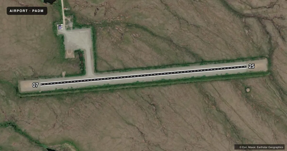
Airport sketch
Runways drawn to scale from FAA survey coordinates, rendered over satellite imagery. Not for navigation.
Approaches & charts
Services on the field
Fuel grades, oxygen, maintenance, ramp storage and lighting — as declared to the FAA by the airport operator.
Fuel & services
- Fuel
- Not available
Ramp & ground
- Transient storage
- Tie-down
- Lighting schedule
- SEE RMK
- Beacon schedule
- SS-SR
- Beacon
- White / Green (civil land)(WG)
- Wind indicator
- Lighted
- Segmented circle
- Yes
Fuel & FBOs
Cheapest 100LL and Jet A on the field and nearby. Always confirm with the FBO before taxi.
Airport notes
Surface conditions, obstructions, local procedures, lighting outages and other notes published with each FAA cycle.
General notes
- RWY COND UNMNT; RCMD VISUAL INSP BFR USE.
- WINTER SNOW REMOVAL OPS - MNT CTAF.
- WX CAMERA AVBL ON INTERNET AT HTTPS://WEATHERCAMS.FAA.GOV
- COLD TEMPERATURE AIRPORT. ALTITUDE CORRECTION REQUIRED AT OR BELOW -26C.
Lighting notes
- ACTVT REIL RWY 07; MIRL RWY 07/25 - CTAF.
Other notes
- PRVDD PROPOSED ARPT DEVELOPMENT IDENTIFIED ON ALP REQUIRING ENVIRONMENTAL PROCESSING BE UNDERTAKEN W/PRIOR WRITTEN APPROVAL FM THE FAA.
- 07/25SFC CRACKING ALG EDGES.
VFR map & nearby airports
VFR sectional. Tap any ICAO chip to open that airport.
Key facts · PADM
Answer card- ICAO
- PADM
- Name
- MARSHALL DON HUNTER SR
- Location
- MARSHALL, ALASKA
- Elevation
- 115.3 ft MSL
- Traffic pattern altitude
- 1,115.3 ft MSL (1,000 AGL)
- Control tower
- Non-towered (use CTAF)
- Total runways
- 1
- Longest runway
- 07/25 · 3,200 ft
- Published ILS approaches
- 0
- Published frequencies
- 1
- Magnetic variation
- 13°
- Current flight rules
- VFR
- Current wind
- 230° at 7 kt
- Favored runway now
- RWY 25
Marshall Don Hunter Sr Airport (PADM) sits in Marshall, Alaska. Field elevation is 115.3 ft MSL. The airport has one runway. Runway 07/25 is 3,200 ft long and gravel. The runway headings are 85° and 265° magnetic. There is no control tower. CTAF is 122.9.
No ILS approaches are published here. Pattern altitude is not published, so use the standard 1,000 ft AGL for light piston operations unless the current Chart Supplement says otherwise. The airport is a cold temperature field. Altitude correction is required at or below minus 26 degrees Celsius. That matters here in winter. Runway condition is unmonitored, so a visual inspection before landing is a good idea. Surface cracking is reported along the edges of runway 07/25.
Runway end identifier lights are on runway 07. Medium intensity runway lights are on both ends and are controlled on CTAF. Winter snow removal operations are also monitored on CTAF. There are no on-field FBOs listed. Check the current Chart Supplement or call the airport operator or the field directly for any current services before you go. A weather camera is available online for a quick look at field conditions.