METAR & TAF PAAC
PAAC does not publish a METAR.
Showing the nearest reporting station: PASM (ST MARY'S) · 11.8 NM away. Conditions at PAAC may differ.
METAR · PASM
Observed 04:56Z
PASM 280456Z AUTO 23008KT 10SM BKN025 OVC036 12/07 A3000 RMK AO2 RAB01E33 SLP165 P0000 T01170072
- Wind
- 230° @ 8 kt
- Visibility
- 10 SM
- Temp / Dew
- 12°C / 7°C
- Altimeter
- 30.00 inHg
- Clouds
- OVC
- Density alt
- 127 ft
- Ceiling
- 2,500 ft AGL
- Rules
- MVFR
Airport info & contacts
Manager on record, flight service, ARTCC, attendance schedule and pattern altitude — published by the FAA and refreshed every 28 days.
Location
- From city
- 3 NM NW
- VFR sectional
- BETHEL
- ARTCC
- ZAN · ANCHORAGE
- NOTAM facility
- ENA (NOTAM-D)
Airport manager
- Name
- ERIK WEINGARTH
- Phone
- 907-438-2416
- Address
- BOX 135, ST MARY'S AK 99658
Flight service · Hours
- FSS ENA
- KENAI907-283-72111-866-864-1737
- Attendance
- Unattended
Frequencies
Tap any row to copy the frequency to your clipboard.
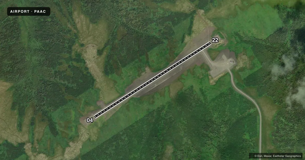
Runways & pattern
Full pagePattern entry · RWY 22
LEFT TRAFFICAirport sketch
Runways drawn to scale from FAA survey coordinates, rendered over satellite imagery. Not for navigation.
Approaches & charts
Services on the field
Fuel grades, oxygen, maintenance, ramp storage and lighting — as declared to the FAA by the airport operator.
Fuel & services
- Fuel
- Not available
Ramp & ground
- Transient storage
- Not published
- Landing fee
- No fee published
- Customs
- Not available
- Lighting schedule
- SEE RMK
- Beacon schedule
- SEE RMK
- Beacon
- White / Green (civil land)(WG)
- Wind indicator
- Yes
- Segmented circle
- Yes
Fuel & FBOs
Cheapest 100LL and Jet A on the field and nearby. Always confirm with the FBO before taxi.
Airport notes
Surface conditions, obstructions, local procedures, lighting outages and other notes published with each FAA cycle.
General notes
- RWY COND UNMNT; RCMD VISUAL INSP BFR LNDG.
Lighting notes
- ACTVT ROTG BCN - CTAF.
- ACTVT MIRL RWY 04/22 - CTAF.
VFR map & nearby airports
VFR sectional. Tap any ICAO chip to open that airport.
Key facts · PAAC
Answer card- ICAO
- PAAC
- Name
- PILOT STATION
- Location
- PILOT STATION, ALASKA
- Elevation
- 473 ft MSL
- Traffic pattern altitude
- 1,473 ft MSL (1,000 AGL)
- Control tower
- Non-towered (use CTAF)
- Total runways
- 1
- Longest runway
- 04/22 · 4,000 ft
- Published ILS approaches
- 0
- Published frequencies
- 1
- Magnetic variation
- –
- Current flight rules
- MVFR
- Current wind
- 230° at 8 kt
- Favored runway now
- RWY 22
Pilot Station Airport sits in Pilot Station, Alaska. The field elevation is 473 ft MSL. It has one runway. Runway 04/22 is 4,000 ft long and surfaced with gravel and dirt. There is no control tower. CTAF is 122.9.
No ILS approaches are published here. The pattern altitude is not published. Use the standard 1,000 ft AGL for light piston operations unless the current Chart Supplement says otherwise. That puts pattern work at about 1,473 ft MSL based on field elevation. Confirm the published traffic pattern before you go. Runway condition is unmonitored, so plan a careful visual check before landing. The rotating beacon is activated on CTAF. Medium intensity runway lights for 04/22 are also activated on CTAF.
No on-field FBOs are listed. Plan on self-sufficiency and verify services with the airport operator or the field on CTAF before arrival. For a first-time arrival, the big items are the gravel-dirt surface, the unmonitored runway condition and the lack of published instrument approach support. In Alaska, weather and visibility can change fast. Make sure your alternate and fuel plan are solid before you launch.