METAR & TAF PAAU
PAAU does not publish a METAR.
Showing the nearest reporting station: PAEM (EMMONAK) · 18.7 NM away. Conditions at PAAU may differ.
METAR · PAEM
Observed 16:56Z
PAEM 091656Z AUTO 7SM OVC005 A3010 RMK AO2 SLPNO FZRANO PNO $
- Wind
- Calm
- Visibility
- 7 SM
- Temp / Dew
- —
- Altimeter
- 30.10 inHg
- Clouds
- OVC
- Density alt
- —
- Ceiling
- 500 ft AGL
- Rules
- IFR
Airport info & contacts
Manager on record, flight service, ARTCC, attendance schedule and pattern altitude — published by the FAA and refreshed every 28 days.
Location
- From city
- 0 NM S
- VFR sectional
- BETHEL
- ARTCC
- ZAN · ANCHORAGE
- NOTAM facility
- ENA (NOTAM-D)
Airport manager
- Name
- JOHN WILSON
- Phone
- 907-625-1025
- Address
- BOX 192, UNALAKLEET AK 99684
Flight service · Hours
- FSS ENA
- KENAI907-283-72111-866-864-1737
- Attendance
- Unattended
Frequencies
Tap any row to copy the frequency to your clipboard.
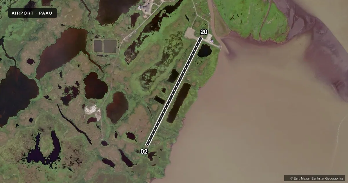
Runways & pattern
Full pagePattern entry · RWY 02
LEFT TRAFFICRunway end performance
| End | TORA | TODA | ASDA | LDA | VGSI | Approach lights | Obstruction |
|---|---|---|---|---|---|---|---|
| 02 | — | — | — | — | — | — | 2', brush, 0' from thr, 0' R of cntrln, slope 0 |
| 20 | — | — | — | — | — | — | 2', brush, 0' from thr, 20' R of cntrln, slope 0 |
Declared distances in feet. TORA = takeoff run available, TODA = takeoff distance, ASDA = accelerate-stop, LDA = landing distance.
Airport sketch
Runways drawn to scale from FAA survey coordinates, rendered over satellite imagery. Not for navigation.
Approaches & charts
Services on the field
Fuel grades, oxygen, maintenance, ramp storage and lighting — as declared to the FAA by the airport operator.
Fuel & services
- Fuel
- Not available
Ramp & ground
- Transient storage
- Not published
- Landing fee
- No fee published
- Customs
- Not available
- Lighting schedule
- SEE RMK
- Beacon schedule
- SEE RMK
- Beacon
- White / Green (civil land)(WG)
- Wind indicator
- Lighted
- Segmented circle
- Yes
Fuel & FBOs
Cheapest 100LL and Jet A on the field and nearby. Always confirm with the FBO before taxi.
Airport notes
Surface conditions, obstructions, local procedures, lighting outages and other notes published with each FAA cycle.
General notes
- RWY 02/20 COND UNMNT; RCMD VISUAL INSP BFR LNDG.
- CTN: FLOATPLANE TFC USES RIVER N OF ARPT.
- WATER LANES ELEV 0.0 FT; UNMNT OR MNTND; EXP STRONG WINDS WHEN LNDG.
Lighting notes
- ROTG BCN ON CONSLY.
- ACTVT MIRL RWY 02/20 - CTAF.
Other notes
- 02/20SOFT DURG RAIN & SPRING BREAKUP.
VFR map & nearby airports
VFR sectional. Tap any ICAO chip to open that airport.
Key facts · PAAU
Answer card- ICAO
- PAAU
- Name
- NUNAM IQUA
- Location
- NUNAM IQUA, ALASKA
- Elevation
- 17.6 ft MSL
- Traffic pattern altitude
- 1,017.6 ft MSL (1,000 AGL)
- Control tower
- Non-towered (use CTAF)
- Total runways
- 1
- Longest runway
- 02/20 · 3,016 ft
- Published ILS approaches
- 0
- Published frequencies
- 1
- Magnetic variation
- 8°
- Current flight rules
- IFR
- Current wind
- Calm / unavailable
- Favored runway now
- –