METAR & TAF PACM
Current METAR
Observed 06:13Z
PACM 280613Z AUTO 21005KT 10SM OVC030 10/06 A2998 RMK AO2 $
- Wind
- 210° @ 5 kt
- Visibility
- 10 SM
- Temp / Dew
- 10°C / 6°C
- Altimeter
- 29.98 inHg
- Clouds
- OVC
- Density alt
- -647 ft
- Ceiling
- 3,000 ft AGL
- Rules
- MVFR
Airport info & contacts
Manager on record, flight service, ARTCC, attendance schedule and pattern altitude — published by the FAA and refreshed every 28 days.
Location
- From city
- 0 NM N
- VFR sectional
- BETHEL
- ARTCC
- ZAN · ANCHORAGE
- NOTAM facility
- SCM (NOTAM-D)
Airport manager
- Name
- JOSEPH LARAUX
- Phone
- 907-543-2498
- Address
- PO BOX 505, BETHEL AK 99559
Flight service · Hours
- FSS ENA
- KENAI907-283-72111-866-864-1737
- Attendance
- Unattended
Frequencies
Tap any row to copy the frequency to your clipboard.
Runways & pattern
Full pagePattern entry · RWY 29
RIGHT TRAFFICRunway end performance
| End | TORA | TODA | ASDA | LDA | VGSI | Approach lights | Obstruction |
|---|---|---|---|---|---|---|---|
| 29 | — | — | — | — | — | — | 3', brush, 0' from thr, 80' R of cntrln, slope 0 |
Declared distances in feet. TORA = takeoff run available, TODA = takeoff distance, ASDA = accelerate-stop, LDA = landing distance.
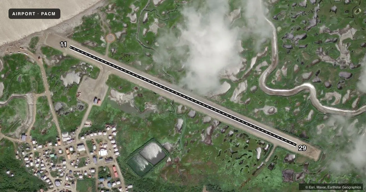
Airport sketch
Runways drawn to scale from FAA survey coordinates, rendered over satellite imagery. Not for navigation.
Approaches & charts
Services on the field
Fuel grades, oxygen, maintenance, ramp storage and lighting — as declared to the FAA by the airport operator.
Fuel & services
- Fuel
- Not available
Ramp & ground
- Transient storage
- Not published
- Landing fee
- No fee published
- Customs
- Not available
- Lighting schedule
- SEE RMK
- Beacon schedule
- SEE RMK
- Beacon
- White / Green (civil land)(WG)
- Wind indicator
- Lighted
- Segmented circle
- Yes
Fuel & FBOs
Cheapest 100LL and Jet A on the field and nearby. Always confirm with the FBO before taxi.
Airport notes
Surface conditions, obstructions, local procedures, lighting outages and other notes published with each FAA cycle.
General notes
- RWY COND UNMNT; RCMD VISUAL INSP BFR TO USE.
- BIRDS ON RWY.
- WX CAMERA AVBL ON INTERNET AT HTTPS://WEATHERCAMS.FAA.GOV/.
- PSBL GUSTY XWIND.
- COLD TEMPERATURE AIRPORT. ALTITUDE CORRECTION REQUIRED AT OR BELOW -20C.
Lighting notes
- ACTVT ROTG BCN - CTAF.
- ACTVT MIRL RWY 11/29 - CTAF.
Runway surface & condition
- 11/29EDGES SOFT & SLOUGHING TWD TUNDRA. ROAD XS RWY.
Approach & departure obstructions
- 29SAFETY AREA SOFT WITH LRG ROCK; ONLY 75 FT USBL.
- 11CONES & REFLECTIVE THR PANELS; PANELS DAMAGED OR MISSING.
- 29CONES & REFLECTIVE THR PANELS.
Other notes
- SPB ASP: ESTABD PRIOR TO 1959.
- UNRELBL.
- 11/29SOFT DURG SPRING BREAKUP, AFT RAIN & HIGH TIDE.
VFR map & nearby airports
VFR sectional. Tap any ICAO chip to open that airport.
Key facts · PACM
Answer card- ICAO
- PACM
- Name
- SCAMMON BAY
- Location
- SCAMMON BAY, ALASKA
- Elevation
- 22 ft MSL
- Traffic pattern altitude
- 1,022 ft MSL (1,000 AGL)
- Control tower
- Non-towered (use CTAF)
- Total runways
- 1
- Longest runway
- 11/29 · 3,001 ft
- Published ILS approaches
- 0
- Published frequencies
- 2
- Magnetic variation
- 8°
- Current flight rules
- MVFR
- Current wind
- 210° at 5 kt
- Favored runway now
- RWY 29
Scammon Bay Airport sits in Scammon Bay, Alaska. Field elevation is 22 ft MSL. The airport has one runway. Runway 11/29 is 3,001 ft long and has a dirt surface. There is no control tower. CTAF and UNICOM are both 123.0. No ILS approaches are published.
Pattern altitude is not published. Use the standard 1,000 ft AGL pattern unless local guidance says otherwise. That puts the light piston pattern at about 1,022 ft MSL based on the field elevation. Check the current Chart Supplement before you go. This field has a few operational notes that matter. The wind indicator is unreliable. Birds are present on the runway. Runway condition is unmonitored, so a visual check before landing is smart. The surface can get soft during spring breakup. It can also get soft after rain. High tide can affect it too. Runway edges are soft and slough toward tundra. A road crosses the runway. Runway 29 has only 75 ft usable at the end because of a soft safety area with large rock. Runway 11 has cones and reflective threshold panels, though the panels are damaged or missing. The rotating beacon operates on CTAF. Expect possible gusty crosswind and cold weather performance issues. This is a cold temperature airport. Altitude correction is required at or below minus 20 degrees Celsius.