METAR & TAF PAEW
PAEW does not publish a METAR.
Showing the nearest reporting station: PAOO (TOKSOOK BAY) · 23.7 NM away. Conditions at PAEW may differ.
METAR · PAOO
Observed 14:26Z
PAOO 281426Z AUTO 11012KT 10SM -RA FEW007 SCT011 OVC030 09/08 A2999 RMK AO2 TSNO PNO $
- Wind
- 110° @ 12 kt
- Visibility
- 10 SM
- Temp / Dew
- 9°C / 8°C
- Altimeter
- 29.99 inHg
- Clouds
- OVC
- Density alt
- -379 ft
- Ceiling
- 3,000 ft AGL
- Rules
- MVFR
Airport info & contacts
Manager on record, flight service, ARTCC, attendance schedule and pattern altitude — published by the FAA and refreshed every 28 days.
Location
- From city
- 1 NM W
- VFR sectional
- BETHEL
- ARTCC
- ZAN · ANCHORAGE
- NOTAM facility
- ENA (NOTAM-D)
Airport manager
- Name
- NICK NORWOOD
- Phone
- 907-543-2498
- Address
- BOX 505, BETHEL AK 99559
Flight service · Hours
- FSS ENA
- KENAI907-283-72111-866-864-1737
- Attendance
- Unattended
Frequencies
Tap any row to copy the frequency to your clipboard.
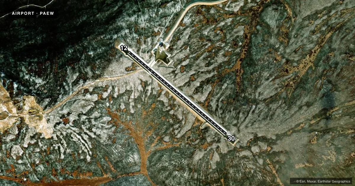
Runways & pattern
Full pagePattern entry · RWY 12
LEFT TRAFFICAirport sketch
Runways drawn to scale from FAA survey coordinates, rendered over satellite imagery. Not for navigation.
Approaches & charts
Services on the field
Fuel grades, oxygen, maintenance, ramp storage and lighting — as declared to the FAA by the airport operator.
Fuel & services
- Fuel
- Not available
Ramp & ground
- Transient storage
- Not published
- Landing fee
- No fee published
- Customs
- Not available
- Lighting schedule
- SEE RMK
- Beacon schedule
- SEE RMK
- Beacon
- White / Green (civil land)(WG)
- Wind indicator
- Yes
- Segmented circle
- Yes
Fuel & FBOs
Cheapest 100LL and Jet A on the field and nearby. Always confirm with the FBO before taxi.
Airport notes
Surface conditions, obstructions, local procedures, lighting outages and other notes published with each FAA cycle.
General notes
- RWY COND UNMNT; RCMD VISUAL INSP PRIOR TO USE.
Lighting notes
- ACTVT ROTG BCN - CTAF.
- ACTVT MIRL RWY 12/30 - CTAF.
VFR map & nearby airports
VFR sectional. Tap any ICAO chip to open that airport.
Key facts · PAEW
Answer card- ICAO
- PAEW
- Name
- MERTARVIK
- Location
- MERTARVIK, ALASKA
- Elevation
- 345.2 ft MSL
- Traffic pattern altitude
- 1,345.2 ft MSL (1,000 AGL)
- Control tower
- Non-towered (use CTAF)
- Total runways
- 1
- Longest runway
- 12/30 · 3,300 ft
- Published ILS approaches
- 0
- Published frequencies
- 1
- Magnetic variation
- 17°
- Current flight rules
- MVFR
- Current wind
- 110° at 12 kt
- Favored runway now
- RWY 12
Mertarvik Airport sits in Mertarvik, Alaska. Field elevation is 345.2 ft MSL. The airport has one runway. Runway 12/30 is 3,300 ft long and gravel. The longest runway is 3,300 ft. There is no control tower. CTAF is 122.9.
No ILS approaches are published here. Pattern altitude is not published, so use the standard 1,000 ft AGL for light piston operations unless the current Chart Supplement says otherwise. Runway 12 has flexible markers and reflective cones. Runway 30 has the same setup. The rotating beacon is activated by CTAF. Medium intensity runway lights on 12/30 are also activated by CTAF. Runway condition is unmonitored. A visual inspection before landing is a good idea.
There are no on-field FBOs listed. Plan on self-sufficiency and verify current services with the airport operator before you go. This is a remote Alaska field. Weather, surface condition and runway visibility deserve extra attention. Check the current Chart Supplement for any published restrictions before departure.